Published July 26, 2011 01:22PM
Backyard Everests: Stone Mountain
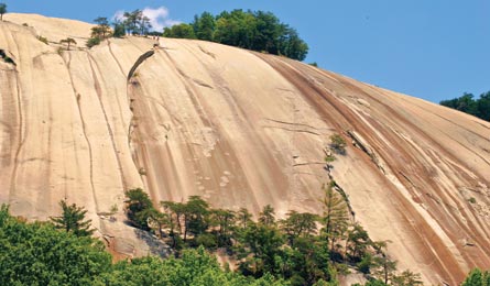
Top a Yosemite-like dome in a sea of green.
'(Pat & Chuck Blackley)'
Stone Mountain isn’t the highest peak in the East, but its prominence and isolation make it feel that way. You’ll nab peerless views of the rolling green Piedmont, see a 200-foot waterfall, and have a chance to fish what locals call the state’s finest trout streams. Watch rock climbers on the mountain’s slabby south face as you loop around and up to the summit of this granite dome.
DO IT The 4.5-mile Stone Mountain Loop begins at the upper trailhead on the west side of Stone Mountain State Park and quickly descends 300 stairs from the top of 200-foot Stone Mountain Falls. Walk through the grassy meadow below the steep south face with more than 30 technical rock routes that line the granite wall, and look for some of the giant granite blocks that have exfoliated off the wall over the years. From the meadow, it’s a stout 700-foot climb in .6 mile to the summit through stands of pine and oak. Be wary of how far you wander down the rock slab from the summit—it steepens down slope and is treacherous when wet. Minimal mileage leaves plenty of time for fishing the park’s 17 miles of brown, rainbow, and brookie-laden streams. Pack your fly rod and a selection of nymphs and dry flies to cast into Big Sandy Creek.
CLIMBING MAGAZINE RECOMMENDS Friction climbing and keeping it together during huge runouts are the name of the game on Stone Mountain’s water-groove route, Great White Way, a three-pitch, 5.9 sport climb that requires only four quickdraws.
GET THERE From Charlotte, take I-77 75 miles north to US 21. Go 12 miles, to Traphill Rd. Turn west and drive four miles to the John P. Frank Parkway. Turn north into Stone Mountain State Park and reach the upper trailhead in three miles.
GUIDEBOOK Hiking North Carolina: A Guide to Nearly 500 of North Carolina’s Greatest Hiking Trails, by Randy Johnson ($20, falcon.com)
MAP USGS quad Glade Valley
CONTACT (336) 957-8185; ncparks.gov
TRIP DATAbackpacker.com/hikes/stonemountain
ELEVATION 2,035 feet
GAIN 1,000 feet
MILES 4.5
ROUTE Stone Mountain Trail
DRIVE 1 hour, 45 minutes