Published July 26, 2011 01:02PM
Backyard Everests: Spruce Knob
Stand atop The Mountain State's most famous peak.
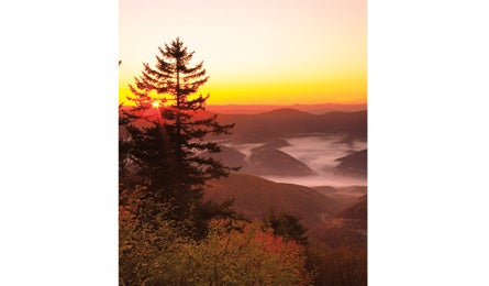
'(Pat & Chuck Blackley)'
There are shorter routes to West Virginia’s highest peak, but this 11-mile point-to-point is the ultimate scenic route. It crests the ridge of Allegheny Mountain, dips into Seneca Creek, and shoots 1,400 feet to the summit. Plus: Pass Seneca Rocks, one of the East’s premier trad-climbing areas on the drive.
DO IT From Spring Ridge trailhead, head east, climbing three miles to the Allegheny Mountain Trail. Hike it east along a gentle ridge .2 mile to the Horton Trail, leading one mile to Seneca Creek Trail. Take it 1.4 miles to the backcountry campsites at the Judy Springs Campground. Next day, continue .5 mile to the Horton Trail. Walk it 500 feet south to link the Lumberjack and Huckleberry Trails to the ridge of Spruce Mountain, hitting the summit in 4.5 miles.
CLIMBING MAGAZINE RECOMMENDS The two-pitch Soler, a classic 5.7 first climbed in 1951, tops out on the South Peak of Seneca Rocks, the highest 5th-class summit east of Devils Tower.
GET THERE Shuttle car: From D.C., take I-66 west 75 miles to I-81 and head south four miles to VA 55. Go 89 miles to a right on CR 33 south of Seneca Rocks. In 2.5 miles, turn right on FR 112 and drive 7.5 miles to FR 104, which leads to parking atop Spruce Mountain. Trailhead: Take FR 104 to FR 112. Turn right and go six miles to FR 1. Take it 11.5 miles (becomes CR 29) to Spring Ridge trailhead.
GUIDEBOOK Hiking West Virginia, by Steven Carroll and Mark Miller ($16, falcon.com)
MAP USGS quads Whitmer, Onega, Circleville, and Spruce Knob
CONTACT (304) 257- 4488; fs.usda.gov/mnf
TRIP DATAbackpacker.com/hikes/spruceknob
ELEVATION 4,863 feet
GAIN 2,680 feet
MILES 9.8
ROUTE Spring Ridge, High Meadows, and Huckleberry Trails
DRIVE 3 hours, plus 1.25 hours for shuttle