Published July 26, 2011 01:33PM
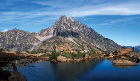
Backyard Everests: Mt. Stuart
Scramble a sneak route to Rainier-worthy views-of Rainier and much more.
'(Geoffrey Sandine)'
To live in Seattle is to have an embarrassment of life-list mountains within a few hours of your door. But only Mt. Stuart couples both the alpine rewards of high-profile peaks like Adams and Rainier with the solitude that most hikers only experience on weeklong trips. This summit rises more than 5,000 feet from the surrounding terrain, testing quads and lungs alike—but you won’t need to rope up or pack crampons. Stuart is the highest mountain in the Enchantment Range, overlooking the entire Alpine Lakes Wilderness. Some speculate that it’s the largest chunk of exposed granite in the United States. Bonus: You’ll be able to see your entire summit-day climb from the hike in.
DO IT From the Esmeralda trailhead, hike the Ingalls Way Trail past several small waterfalls up switchbacks to 6,200-foot Longs Pass at 2.5 miles, then descend a rocky climbers’ trail to Ingalls Creek. Cross the creek and find the Ingalls Creek Trail, which parallels the stream. Head southeast along the creek a short distance to a small meadow on the left to set up camp. Locate the faint climbers’ trail heading northeast before settling in for the night (it can be tricky to find via headlamp during your alpine start). It leads to the Cascadian Couloir climbing route. Mountain goats may mingle with you on your way up the rocky terrain in the class 3, 3,500-vertical-foot, 30-degree couloir. At the top of the chute, continue up talus to a notch east of a false summit. Pick your way across the ridge and up a slab to the summit. Pack a helmet—rockfall (usually goat-triggered) is common.
CLIMBING MAGAZINE RECOMMENDS Find out why the 15 pitches of exposed, often knife-edge 5.9 alpine climbing earned the North Ridge a spot in Fifty Classic Climbs of North America.
GET THERE From Seattle, take I-90 82 miles east to WA 970 in Cle Elum. Then go 9.3 miles to a left onto Teanaway Rd. Go nine miles to a Y intersection. Veer right onto FR 9737 and continue to Esmeralda trailhead.
GUIDEBOOK Climbing Washington’s Mountains, by Jeff Smoot ($30, falcon.com)
MAP USGS quad Mount Stuart
PERMITS Required (free at trailhead register). A Northwest Forest Pass is required to park at the trailhead (800) 270-7504, naturenw.org
CONTACT (509) 852-1100; fs.fed.us/r6/wenatchee/cle-elum-wilderness
TRIP DATAbackpacker.com/hikes/mtstuart
ELEVATION 9,415 feet
GAIN 8,200 feet
MILES 13
ROUTE Cascadian Couloir via Ingalls Creek Trail
DRIVE 2 hours, 20 minutes