Published July 26, 2011 11:31AM
Backyard Everests: Lone Pine Peak, Inyo National Forest
Climb without crowds to the state's top mountain view.
'BP0911PEAK_Callaert_LonePine_445'
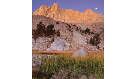
From Lone Pine Peak’s blocky granite summit, you’ll score pulpit-in-cathedral views of the jagged mountains of the Sierra, including a full third of California’s Fourteeners—and you’ll likely have those vistas all to yourself. Although visitors to the town of Lone Pine often gaze up at this peak towering 9,000 feet above the desert floor and mistake it for its taller and more famous neighbor (Mt. Whitney, the state’s highest), it sees a fraction of the traffic of the crowded Whitney Trail. The Meysan Lake Trail starts right next door and will feel like the best-kept secret in the range as you climb steeply to campsites at Grass Lake. Pitch a tent here, just below the Northwest Slope route, your access to the 12,944-foot summit.
DO IT From the Whitney Portal Campground, take the Meysan Lake Trail and ascend 3,300 feet over 4.7 miles on the hillside next to gurgling Meysan Creek. The views open up at tiny Grass Lake, nestled among pines and clean alpine granite. Find quality campsites here, under the imposing east face of Mt. Irvine. In the morning—with a pre-dawn start to beat near daily afternoon thunderstorms—head south to the class 2 talus chute on the peak’s northwest side and climb it for 1,500 vertical feet. Head left at the summit plateau and stay right to avoid the false summits on the ridge on the way to the top. After you return from the 3.5-mile, 2,000-vertical-foot climb, save time for a fishing detour. A short side trail heads upstream from your campsite to Meysan Lake, originally stocked with brook trout in the 1920s by its namesake, homesteader Felix Meysan. Look for grouse and deer in the morning and evening on the Meysan Lake Trail.
CLIMBING MAGAZINE RECOMMENDS Plan for an epic day on Lone Pine Peak’s three-mile long, 5.6 Northeast Ridge route. Most parties can expect 10 hours of climbing, plus a five-hour class 2 descent from
the summit.
GET THERE From LA, take US 395 165 miles to Lone Pine. Turn west on Whitney Portal Rd. and go 13 miles to its end.
GUIDEBOOK The High Sierra: Peaks, Passes, and Trails, by R.J. Secor ($33, mountaineersbooks.org)
MAP USGS quad Mount Langley
PERMIT Required (free in person, $5 in advance, see Contact)
CONTACT (760) 876-6200; fs.usda.gov/inyonationalforest-home
TRIP DATAbackpacker.com/hikes/lonepinepeak
ELEVATION 12,944 feet
GAIN 5,000 feet
MILES 12
ROUTE Northwest ridge via Meysan Lake Trail
DRIVE 3 hours, 30 minutes