Updated July 8, 2025 09:43AM
Hike Alpine Lakes in the John Muir Wilderness, California
Find your own secret spot on this trek through the Sierra.
'William M. Rochfort, Jr.'
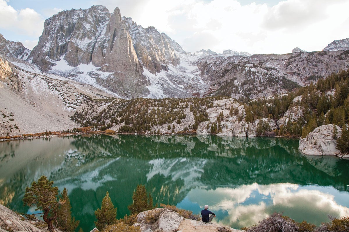
It’s our first backpacking trip together. Might as well be the first date all over again, I think to myself as I feel the pressure build. One misstep could undermine future hiking and camping for us for years to come. What if she doesn’t like my favorite spot? But I can’t see that happening, not on this itinerary: We’ll follow the riverside trail, splitting a valley between 12,000-foot peaks where waterfalls spill year-round, to the seven Big Pine Lakes. We’ll stop at my spot: Second Lake, a turquoise pool below the pointy pinnacles of Temple Crag. There, we’ll enjoy a romantic lunch of smushed PB&Js on a granite shelf that overhangs the water like a diving board. Then, before the sun sets, we’ll take a hike around the five higher lakes. I’ll bust out my old-fashioned fishing pole, we’ll leap into the frigid water, and we’ll gaze at the granite edifices in every direction. In the morning, sunrise will light up the Palisades, and we’ll walk back more connected—to the landscape and each other—than ever.
Turn-by-turn From the Big Pine Creek Trailhead
1) Head 4.1 miles west on the North Fork Big Pine Creek Trail, following signs for “Big Pine Lakes,” as it steadily ascends 2,000 feet to a junction for the Big Pine Lakes Loop.
2) Veer south to reach the lower lakes, continuing .4 mile past First Lake to Second Lake.
3) Retrace your steps to the trailhead.
ADVERTISEMENT
Campsite Second Lake (mile 4.5)
The view from the granite bench on the north shore of teal Second Lake may be the closest you get to the Alps in California: Angle your tent to face the castle-like turrets of the cirque, including imposing Temple Crag, which looms nearly 3,000 feet above the water. (Tip: Trace the lake counterclockwise to find the best cliff-jumping spots on the northwest shore.)
Day Trips
Options abound. Take the 6-mile Big Pine Lakes Loop to tour the five other alpine pools or visit Palisade Glacier (the Sierra’s biggest sheet of ice) on a 5-mile out-and-back. For a complete guide to the area, visit backpacker.com/200-miles-of-awesome-in-california.
Do It
TRAILHEAD: 37.1253, -118.4375; 10 miles west of Big Pine on Glacier Lodge Rd.
SEASON: June to October
PERMIT: Required for overnighting ($10 + $5/person); reserve online or obtain from any Inyo National Forest ranger station.
CUSTOM MAP ($15)
DISTANCE: 9 miles (out and back)
TIME: 2 days
DIFFICULTY: 2.5/5