Updated December 3, 2024 10:26PM
Asulkan Valley, Glacier National Park
Hit four technical summits in the birthplace of North American mountaineering.
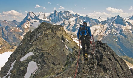
'Jupiter Traverse in Glacier National Park, British Columbia (Steve Howe)'
Canada’s Glacier National Park, 200 miles north of Idaho in the moist Columbia Mountains, boasts all of the craggy splendor of its Montana namesake, but with more glaciers, more grizzlies, and better rock. In 1899, Swiss guides led the continent’s first alpine expeditions up the park’s then-unclimbed summits. Follow in their handholds in the historic Rogers Pass region on this 17.4-mile, four-day sampler of the area’s glacial terrain. Pack crampons, ice axe, crevasse rescue gear, a 30-meter rope, and a light rack (and have the skill to use them) or hire a guide (below).
From the Illecillewaet trailhead, backpack in 5.1 miles, gaining 2,900 feet to the Alpine Club of Canada’s Asulkan Hut, a two-story palace of wood and glass that sleeps 12. Day two, scout the neighborhood with a half-day climb of 9,341-foot Youngs Peak, a glaciated 1.5-mile, class 3 ascent just south of the hut. The summit offers vistas of the massive granite chisel of 10,816-foot Mt. Sir Donald and the broad icefields of the Glacier Crest.
The next day, embark on the Jupiter Traverse, a strenuous but technically straightforward 4.7-mile, class 4 climb across the three sub-peaks of 9,140-foot Mt. Jupiter, which dominates the hut’s western skyline. Wind through glacial icefalls on the Thorington Route to 8,361-foot Leda, Jupiter’s southernmost summit, then scramble across the exposed-but-easy quartzite knife-edge to the other sub-peaks, Pollux and Castor. Here you face a decision: Down climb steep, shattered ridgeline to a four-person metal bivouac shelter on icebound Sapphire Col (slow class 4), or return the way you came (easier, and a day shorter).
ADVERTISEMENT
If you sleep in the Sapphire Col shelter, return to the Asulkan Hut and its approach trail by descending northeast to the foot of the icefield.
MapChrismar Adventure Map Glacier NP–Rogers Pass ($13CAD; 905-852-6151; chrismar.com); NTS quad 082N05 ($16CAD for waterproof versions; 888-545-8111; fedmaps.com)
Huts $36CAD/person/night; (403) 678-3200; alpineclubofcanada.ca; Askulkan includes stove, fuel, cookward and sleeping pads; Sapphire Col is unequipped.
Guide Revelstoke Alpine Adventures; (877) 837-7141; revelstokealpine.ca
Contact (250) 837-7500; pc.gc.ca
Permit Entry $8CAD/person/day; Backcountry$10CAD/person/night
Map & GPS databackpacker.com/hikes/1395655
>> Online Trip Planning Extras
Get There Start from Illecillewaet Trailhead a mile south of Rogers Pass on Highway 1 (Trans Canada Highway) between Golden and Revelstoke, 220 miles west of Calgary International Airport, Alberta.
Revelstoke (Glacier National Park gateway)
>> Lodging: Poppi’s Guest House (inexpensive, rooms w/shared baths, info exchange with other guests, convenient location) (250) 837-9192; poppis.ca