Updated December 4, 2024 12:12AM
Best Hikes Ever: Escalante Route, AZ
Plumb the wild depths of the Big Ditch.
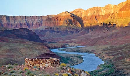
'Hilltop Ruin, Grand Canyon National Park (Leon Werdinger)'
| BEST HIKES EVER HOME |
This five-day, 33-mile blockbuster includes a life-list rim-to-river journey and so much more. “You also enjoy al fresco sleeping most nights on the river, a little class 3 scrambling, and crawling through a slot canyon—pretty much the whole spectrum of essential Grand Canyon experiences,” raves Southwest Editor Annette McGivney, who has written about the Escalante Route several times (including “Hike Through Geologic Time,” December 2001). “There’s no better route for the access, solitude, and scenery.” Intermediate backpackers will find this trek through the vastness of this sandstone labyrinth challenging but doable—and, dare we say, life-altering. Caution: First-timer? Try an easier route, such as the South Kaibab-Bright Angel Loop (Trip ID56089).
Do it Follow the Tanner Trail as it plunges 4,500 feet over eight miles from the South Rim to the Colorado River, and camp at Tanner Rapids. The next day, hike across the unmaintained, 10-mile Escalante Route and camp at Cardenas Creek. Day three’s hike includes a 30-foot rock scramble and Unkar Overlook, where you hover 1,000 feet above the river and below the canyon’s fiery cliffs. Be sure to overnight at the mouth of Red Canyon, a beach campsite enlivened by the roar of Hance Rapids. On day four, follow the Tonto Trail to a camp at either Hance Creek (with water) or atop Horseshoe Mesa (dry, but great views and it shortens the climb out). Alternatively, if you are a speedy hiker (or have extra time), loop around Horseshoe Mesa on the Tonto Trail and camp along Cottonwood Creek. End with Grandview Trail to Grandview Point. Go in spring or fall for the best weather; avoid summer’s heat.
Resources
Driving Lipan Point (the Tanner trailhead) is 2.3 miles west of the Grand Canyon’s east entrance. Take the park bus back from Grandview Point.
Map Trails Illustrated Grand Canyon National Park ($12, natgeomaps.com)
Permit Required ($10 + $5 per person/day)
Contact (928) 638-7875; nps.gov/grca
Trip ID329099