Published September 20, 2013 02:32PM
Appalachian Trail: Mount Katahdin
Big climb. Big crowds. Bigger reward. This classic 9.8-mile route climbs the tallest peak in Maine, a hiking high point in every sense.
Mapped by Jeff Chow


Trail Facts
- Distance: 7.9
Waypoints
KAT001
Location: 45.8867797851562, -68.9996871948242
Head NE on Hunt Trail/AT from Katahdin Stream Campground to trailhead register (check weather @ ranger station). Look NE to serrated ramparts of Katahdin
KAT002
Location: 45.8937568664551, -68.9899597167969
Moderate ascent following streambed
KAT003
Location: 45.8959350585938, -68.9844665527344
Bear R @ Y (still AT). In 250 ft., cross bridge
KAT004
Location: 45.895565032959, -68.9833297729492
Bear R @ Y (still AT). In 250 ft., cross bridge
KAT005
Location: 45.8955993652344, -68.9682464599609
Pass stream; small grotto just below treeline
KAT006
Location: 45.8978843688965, -68.9565658569336
AT enters The Gateway, a difficult section requiring steep scrambling over jumbled piles of rock with rebar handholds
KAT007
Location: 45.900016784668, -68.9467849731445
Tundralike Tableland: this boulder field was deposited by the glacier that lopped off the mountain’s top
KAT008
Location: 45.8982315063477, -68.9365844726562
Straight @ 4-way on AT; pass Thoreau Spring; precipitous drops of Witherle Ravine to N
KAT009
Location: 45.9044494628906, -68.9214172363281
ADVERTISEMENT
Baxter Peak (5,267 ft.): sign marks N terminus of AT and highest point in ME; on fog-free days, see across hundreds of lakes set among spruce and fir; continue E
KAT010
Location: 45.9029350280762, -68.91796875
Head SE on slim ridge to South Peak (Note: Katahdin has three summits: Baxter, South, and Chimney Peaks)
KAT011
Location: 45.9021530151367, -68.9167251586914
South Peak (5,240 ft.): The Knife Edge extends NE to Pamola, a dome outcrop believed by Abenakis to hold Big K’s moody, weather-controlling deity; backtrack on AT to return
Mt. Katahdin from Baxter State Park
Location: 45.8364181518555, -68.9660263061524
©Jeff Chow
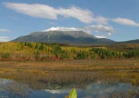
Mt. Katahdin
Location: 45.8821334838867, -69.0302810668945
Katahdin from the west side of Daicey Pond.
©Jeff Chow
Katahdin Ascent
Location: 45.898323059082, -68.9529266357422
©Jeff Chow
The Knife Edge
Location: 45.902027130127, -68.9142532348633
©Jeff Chow