Published September 20, 2013 02:42AM
Appalachian Trail: Harpers Ferry to Pen Mar Road
Have no time to thru-hike the entire Appalachian Trail? No worries. Tackle this 40.5-mile section hike through Maryland over the course of a long weekend.
Shelters: Ed Garvey Shelter: sleeps 12; privy. Crampton Gap Shelter: sleeps 6; privy. Rocky Run Shelter: sleeps 4; privy. Pine Knob Shelter: sleeps 5; privy. Ensign Cowall Shelter: sleeps 8; privy. Devils Racecourse Shelter; sleeps 7.
TO TRAILHEAD: Start: From Washington Street and Union Street in Harpers Ferry, WV, head east on Washington Street for .2 mile to parking on street near Appalachian Trail Conservancy. To access AT, head south on blue-blazed trail along College Storer Place for .2 mile.
End: From Pen Mar, MD, head west on Pen Mar High Rock Rd. (toward Linden Ave.). In .1 mile, turn right at Pen-Mar Rd. In .2 mile, turn left at PA 550/Pen-Mar Rd. Go .1 mile to AT.


Trail Facts
- Distance: 65.1
Waypoints
HAR001
Location: 39.322876, -77.740379
Head east on Appalachian Trail. Blue-blaze trail on left leads .2 mile to Appalachian Trail Conservancy and roadside parking.
HAR002
Location: 39.32275, -77.732902
Pass Jefferson Rock
HAR003
ADVERTISEMENT
Location: 39.322949, -77.73082
Trail to ATC
HAR004
Location: 39.323055, -77.730507
Stone steps; continue heading east.
HAR005
Location: 39.322834, -77.730164
AT turns west on High Street; parking
HAR006
Location: 39.323128, -77.728867
AT turns west
HAR007
Location: 39.323463, -77.728775
Cross footbridge
HAR008
Location: 39.324143, -77.726265
AT turns east after bridge walk.
HAR009
Location: 39.32568, -77.706314
Cross US 340; Sandy Hook Bridge
HAR010
Location: 39.325405, -77.701477
Blue-blazed trail leads to hostel.
HAR011
Location: 39.329273, -77.68148
AT turns west; C&O Canal Towpath.
HAR012
Location: 39.329872, -77.681526
Railroad
HAR013
Location: 39.329872, -77.682495
Kepp Tryst Road
HAR014
Location: 39.331486, -77.685165
I-340 underpass
HAR015
Location: 39.332916, -77.683182
AT turns east.
HAR016
Location: 39.332821, -77.68203
Weverton Road
HAR017
Location: 39.333374, -77.67646
Follow blue blazes to the south for views above the Weverton Cliffs.
HAR018
Location: 39.332176, -77.676598
Weverton Cliffs: Savor great views across the Potomac River, then return to Waypoint 17.
HAR019
Location: 39.360054, -77.662682
ADVERTISEMENT
Pass spur trail to Ed Garvey Shelter on right.
HAR020
Location: 39.359821, -77.662033
Ed Garvey Shelter
HAR021
Location: 39.36655, -77.658859
Pass blue-blaze trail; view to the northwest
HAR022
Location: 39.382858, -77.649086
Continue straight; pipeline.
HAR023
Location: 39.404697, -77.640243
AT turns east.
HAR024
Location: 39.405823, -77.639603
Gapland Road
HAR025
Location: 39.4058, -77.63958
Gapland Road
HAR026
Location: 39.410816, -77.64032
Trail to Crampton Gap Shelter
HAR027
Location: 39.428566, -77.639183
Rocks to the E
HAR028
Location: 39.44445, -77.632835
Blue blaze trail to E; leads to Bear Spring Cabin (may be locked)
HAR029
Location: 39.4478, -77.627098
Side trail to W
HAR030
Location: 39.457333, -77.626404
Road to towers
HAR031
Location: 39.462872, -77.628922
Trail to shelter
HAR032
Location: 39.460968, -77.631119
Rocky Run Shelter
HAR033
Location: 39.464882, -77.624313
At turns W
HAR034
Location: 39.467335, -77.623848
Powerline
HAR035
Location: 39.469734, -77.618401
Terrain becomes open
HAR036
Location: 39.484215, -77.619415
Turners Gap; U.S. Alt. 40
HAR037
Location: 39.484417, -77.619347
Dahlgren Chapel
HAR038
Location: 39.484852, -77.618736
View to SE
HAR039
ADVERTISEMENT
Location: 39.495983, -77.616402
Trail
HAR040
Location: 39.497833, -77.617386
Monument Rd
HAR041
Location: 39.497799, -77.619904
Road
HAR042
Location: 39.499283, -77.623367
Mt. Verno picnic pavilion to S
HAR043
Location: 39.501019, -77.622704
AT turns E @ jct. with trail to Washington Monument
HAR044
Location: 39.499985, -77.62365
Washington Monument
HAR045
Location: 39.504566, -77.620903
Powerline
HAR046
Location: 39.526932, -77.613167
Telephone line
HAR047
Location: 39.527817, -77.6129
Boonsboro Mtn. Rd
HAR048
Location: 39.529915, -77.61087
Bartram hill
HAR049
Location: 39.530567, -77.610016
Blue blaze trail W to Bartram hill
HAR050
Location: 39.534698, -77.608032
Boonsboro Mtn. Rd
HAR051
Location: 39.535049, -77.606186
I-70 footbridge
HAR052
Location: 39.535435, -77.6036
Parking; Greenbrier State Park
HAR053
Location: 39.537632, -77.604134
Trail to E
HAR054
Location: 39.539734, -77.603203
Telephone line
HAR055
Location: 39.540333, -77.602501
Trail to shelter
HAR056
Location: 39.540424, -77.60099
Trail to Pine Knob Shelter
HAR057
Location: 39.540054, -77.600525
Blue blaze E
HAR058
Location: 39.559551, -77.595535
Blue blaze trail W to Annapolis Rock
HAR059
Location: 39.572601, -77.596497
ADVERTISEMENT
Black Rock view
HAR060
Location: 39.57695, -77.588654
Pogo Memorial Campsite
HAR061
Location: 39.577282, -77.588753
Blue Blaze Thurston Griggs Trail to spring; 300 ft.
HAR062
Location: 39.577965, -77.58857
Trail to Pogo Memorial Campsite
HAR063
Location: 39.578934, -77.5886
Trail to W
HAR064
Location: 39.584999, -77.582748
Trail to E
HAR065
Location: 39.588531, -77.581314
Trail to W
HAR066
Location: 39.615658, -77.572563
Spur trail to the E leads to views
HAR067
Location: 39.627701, -77.565964
Rocky top
HAR068
Location: 39.628017, -77.564903
Rocky Descent
HAR069
Location: 39.630001, -77.558937
MD 17; parking
HAR070
Location: 39.630051, -77.558701
Blue blaze trail to the E; parking
HAR071
Location: 39.629749, -77.557549
AT continues straight @ jct. with trail to spring
HAR072
Location: 39.630615, -77.555847
Trail to shelter
HAR073
Location: 39.630882, -77.555931
Ensign Cowall Shelter
HAR074
Location: 39.630516, -77.551964
Caution: Loose rock
HAR075
Location: 39.6371, -77.541214
MD 77
HAR076
Location: 39.647785, -77.539268
Rock wall
HAR077
Location: 39.648033, -77.539314
Rock stairs
HAR078
Location: 39.648716, -77.540436
ADVERTISEMENT
AT turns W
HAR079
Location: 39.650749, -77.542198
AT turns W
HAR080
Location: 39.656315, -77.538666
AT turns E; Warner Gap Hollow Rd
HAR081
Location: 39.664551, -77.536209
PA 491 and Raven Rock Road
HAR082
Location: 39.664799, -77.533234
Blue blaze to Raven Rock Cliff view
HAR083
Location: 39.673275, -77.528343
Trail to shelter
HAR084
Location: 39.671982, -77.524483
Devils Racecourse Shelter
HAR085
Location: 39.693783, -77.522003
High Rock Trail
HAR086
Location: 39.693516, -77.523582
Blue blaze trail to High Rocks view; 2 mi. long
HAR087
Location: 39.717335, -77.508682
View Pen Mar Park
HAR088
Location: 39.71973, -77.507187
Near PA/MD state border; cross rail road
HAR089
Location: 39.720978, -77.507004
Pen Mar Road
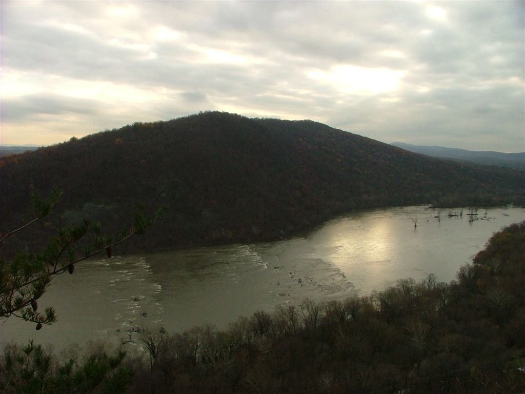
Views of the Potomac River
Location: 39.332184, -77.676537
The Potomac River
Location: 39.33218, -77.676529
The Potomac River flows through Harpers Ferry National Historical Park.
Ed Garvey Shelter
Location: 39.359867, -77.662033
Gathland State Park
Location: 39.405693, -77.639732
I-70 Footbridge
Location: 39.535069, -77.605965
Sunset at Pen Mar
Location: 39.717281, -77.50872