Published October 25, 2021 01:04PM
At This Remote Park, You'll Be the Only Hiker for Miles—If You're Tough Enough to Handle It
Deep in the wilds of Northern British Columbia's Spatsizi Wilderness Provincial Park, our scout proves there’s no joy like misery.

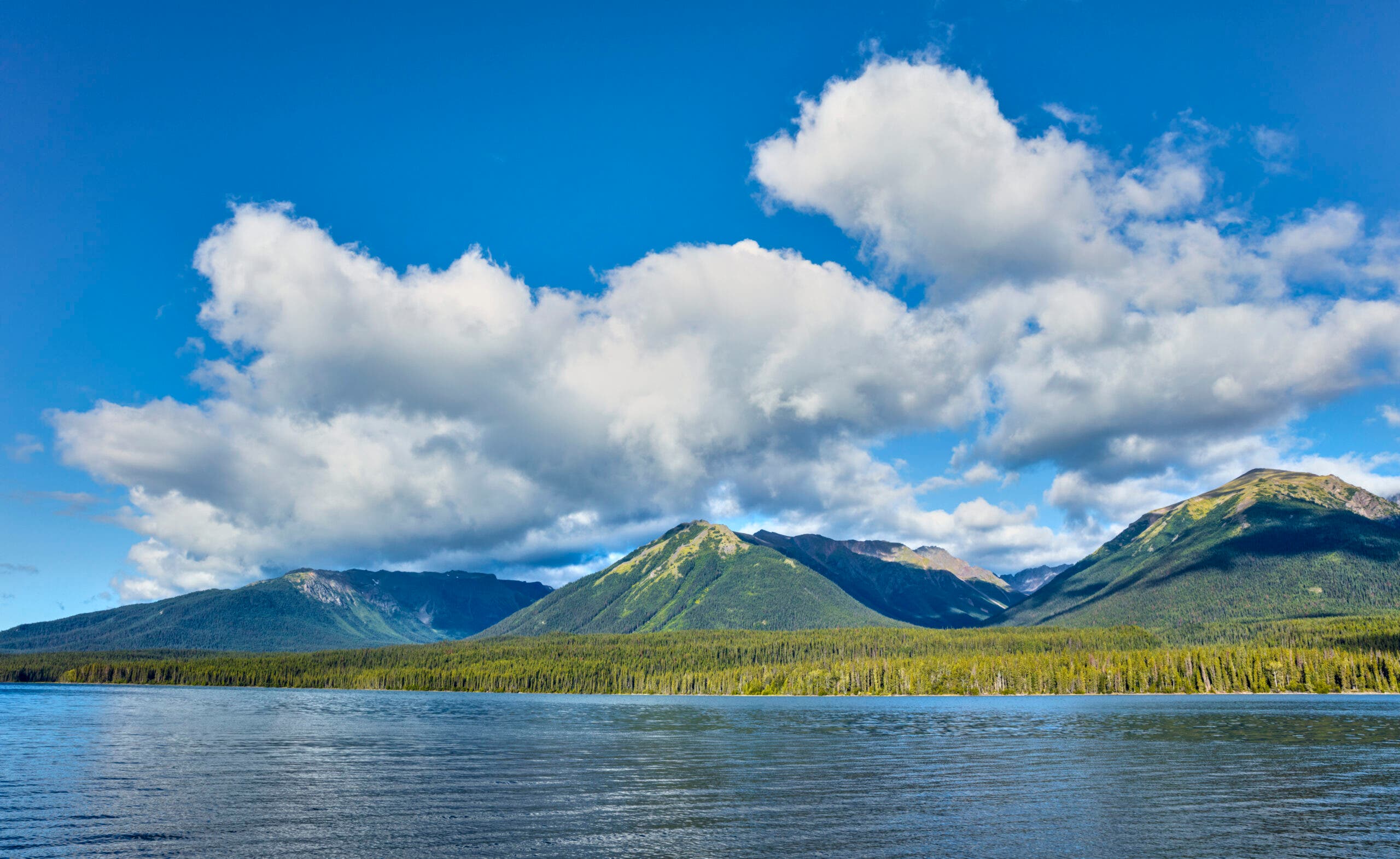
Reflection in the water at dusk at Upper Stikine and Chukachida river confluence, Spatsizi Plateau Wilderness Park, British Columbia, Canada (Photo: gremoni/iStock via Getty Images)
A stagnant bog the size of a football field blocks my way forward. I just scrambled shifting, fridge-size boulders and cut through hedge mazes trying to avoid it, but the terrain funneled me down to the water’s edge. I need to get across. Then, somehow, the miles will contract, the insects will quiet, and the thickets will part like the Red Sea. If I can just get across, I’ll make it to the hunting cabins at British Columbia’s Bug Lake, 9 miles away, in time for pot roast tomorrow night. God, I hope they’re making pot roast.
Beneath the bog’s surface, a rock sits under a thick coat of orange sediment. I’m thinking a Super Mario hop that would briefly submerge one foot in about 12 inches of water should get me to the grassy bank on the other side, where I can skirt the bog entirely. One, two, three. I jump.
My foot plunges through the “rock” and I sink to my navel in the glop. Adrenaline, chill, and fistfuls of grass propel me onto the bank, where I stand panting and dripping. The peaty funk is so foul I’ll probably have to burn these pants when I get back.
ADVERTISEMENT
If I get back. This solo, off-trail trek through Spatsizi Plateau Wilderness Provincial Park—across the gnarliest country I’ve ever seen—is shaping up to be one of the worst ideas in a lifetime of questionable decisions. I’m jelly-legged, sunburnt, sweat-soaked, and mosquito-chewed. But I’m delirious enough to look on the bright side. “At least I cooled off,” I say aloud, though no one can hear me. The mosquitoes make a run at my tonsils.
I’m not necessarily what you’d call a man of prudence. It probably began in youth, when I spent far too many humid Texas weekends tangling with poisonous snakes. I’d take dares to put copperheads down my shirt and clean up on ice cream truck money. Later, I couldn’t sit for two weeks after an 88-foot cliff jump into a mountain pool blew out my swimsuit and left a bruise tattooed across my butt that looked like a bite from a toothless shark. A swollen Denali river nearly extinguished the family bloodline when I coaxed my brother and sister into crossing it on their maiden backpacking trip (sorry, Mom). The biggest fight I’ve had with my wife lately involved me trying to convince her that North Korea would be a lovely place to hike.
So when I heard about a place in northern B.C. so wild and remote it makes Alaska’s Gates of the Arctic look overcrowded, my first reaction was Time for a solo trek! Sure, it would be grueling, a little risky, and possibly painful in ways I hadn’t yet imagined. But it was also guaranteed to deliver the exact kind of experience I crave: that transcendental misery that blooms when I leave my comfort zone. Deprivation, terror, mental and physical anguish—these things elevate a run-of-the-mill backpacking trip into a lifelong memory. Call it the alchemy of suffering: The rocks don’t change to gold, but I do.
ADVERTISEMENT
Plenty of people have experienced this Type II fun (awful when it’s happening, wonderful to remember) by accident when their tent collapses in the night or a sudden storm descends on a summer trip. Few seek it out. But in my experience, I’ve always been rewarded for overreaching. A last-second October trip to the Wind Rivers a few years ago let my brother and I savor the Cirque of the Towers alone—all for the low, low price of some moderate hypothermia. And so my accidents are more like “accidents.” It’s not that I’m some kind of backcountry masochist, though: I just understand that if I make choices that make my stomach churn before I reach my destination, it means I’m about to learn something new about myself—or at least have a great story to tell. But I also know there’s a dark side to this approach: The chance that I won’t see where the envelope ends, that I’ll reach the point where hard is just, well, hard.
MY LATEST PROVING GROUND IS an area 240 miles east of Juneau that sports one two-lane paved road for an area bigger than Oregon. There are a dozen parks in the region, many bigger than U.S. states. Their snows feed three of the biggest salmon rivers in the world (the Stikine, the Skeena, and the Nass), collectively known as the Sacred Headwaters to the native Tahltan people who’ve hunted here since crossing the Bering Land Bridge. I’ve got my eye on Spatsizi Provincial Park, a fearsome bundle of peaks, rivers, lakes, and tundra more than twice the size of Yosemite. The park sometimes sees fewer than a dozen hikers in two whole seasons, but I won’t be alone: It’s home to 3,000 caribou, 2,500 moose, 900 mountain goats, 800 stone sheep (a subspecies of Dall sheep that lives nowhere else), unknown numbers of grizzlies and wolverines, and seven to nine packs of wolves. Spatsizi means “land of the red goat” in Tahltan, for the mountain goats that dye their coats red from rolling in the oxidized dirt on cliff edges.
My plan: spend a week forging into the heart of it all, sampling all of its modes of travel. One enters the core of the park by plane, horse, and foot (in exponentially ascending levels of difficulty). My journey there involves a puddle-jumper flight to the charming alpine hamlet of Smithers, B.C., followed by a six-hour drive north to Tatogga Lake, followed by a floatplane into Spatsizi.
ADVERTISEMENT
Then the real fun begins. I’ll start with one night riding with hunting guides on packhorses, and then head alone and on foot through 19 miles in the trailless heart of the park. That includes the Gladys Lake Eco Reserve, a wild-as-it-gets zone forbidden to hunters and pack animals. Assuming I don’t die in a knife fight with a grizzly or get swept away by folly at river’s edge, I’ll end with a few more nights at a remote, park-maintained cabin on Cold Fish Lake before a floatplane pickup.
The logistics aren’t easy, so I enlisted the help of an outfitting service started here 45 years ago by two brothers, Reg and Ray Collingwood. I wonder if I should tell them I’ve never ridden a horse before.
Mick is a black stallion who doesn’t seem bothered by my nervous fidgeting. But except for being shaky, horsepacking isn’t quite the hardship I expected. The steeds are like breathing, snorting, nimble ATVs of rippling muscle; deep mud, sliding rocks, and thick brush melt away underhoof. Plus, horses do OK on autopilot, giving you the chance to lean back, ride, and let the scenery wash over you.
Good thing. After an hour of trundling through black spruce forest, my guide Max Gauthier and I climb into Icebox Canyon, a series of mile-wide meadows parting giant, snow-striped peaks. We cross a clear, braided stream that rises up to the horses’ knees. They balk—maybe at a log, maybe at the fat grizzly print stamped into the bank—but Mick climbs the far side without pitching me in.
ADVERTISEMENT
At midday, we dismount and hitch the horses at a makeshift camp to continue on foot. Thinning grass yields to tundra, purple gentians, and lichen-covered rock. Iguana-spined arêtes and blocky peaks lift the horizon. Max glasses the ridges, pre-stalking for future clients. He’s a short, strong Quebecois who tells me his present station comes from a childhood ambition to “be a cowboy.” As we walk, he explains about how mountain goats often “Peter Pan” when shot, leaping up and over a ridge in a final death spasm.
We spot three stone sheep nannies and one kid next to a jade lake nestled into the crest of a pass, and Max shows me how to tiptoe up the 35-degree slope and crouch from rock to rock for cover, getting close. Eventually the sheep see me and prance away up a narrow stone staircase cut into a cliff. There’s a nice breeze. The sky is blue. It’s really too damn pleasant.
ADVERTISEMENT
Luckily, we descend in a Pigpen-thick cloud of mosquitoes; they’re so bad I start losing my mind and Max loses his binoculars. We slog up a ridge in an attempt to catch a breeze and some relief. It doesn’t work. Then I remember the head net another guide gave me in a secret handshake when I left. It puts a few inches between my face and the bugs, but we still build a smudge fire when we return to the horses and our camp. We huddle around for a smoke bath while the tethered horses line up inside a white plume. The bugs don’t quiet much even after the Northern twilight blazes into the late evening, and I watch an arrowhead peak above camp go dark against the sky. But I’m no longer fixated on the mosquitoes. I’m wonderfully distracted by my aching bow legs.
The following morning, my training-wheels intro to the Spatsizi backcountry ends. As the wind billows the slate clouds behind us, I say goodbye to Max and Mick on a high, grassy ridge. Ahead, it’s hiker-only country. I’m facing 19 miles of wild terrain in Gladys Lake Eco Reserve, the park’s restricted epicenter. The highest peaks lie in this area, set aside to provide a protected ecosystem. Twenty-six species of mammals and 68 species of birds clot the untouched spruce-willow-birch forests, muskeg bogs, and alpine tundra. In Spatsizi, this is as deep as it gets.
Max wheels around the horse train and snakes away down the ridge. I watch them disappear into a knot of green. I’m finally on my own, committed to the path of most resistance.
ADVERTISEMENT
I recall a cautionary tale Max told me. The bush swallows people whole—like a hunter who disappeared on my route in 2005. Not even a scrap of his gear has ever been found despite multiple searches. I like to think I say yes to dumb things and then make smart decisions once I’m there, but after Max disappears I can’t help but feel the silence press in on my eardrums. I’m standing in the same spot, surrounded by the same tall grass, veiny rivers, and rippling peaks. But now I’m alone and the beauty has a threatening edge it didn’t have a moment ago.
Two feet later, I break the quiet by nearly tripping over a ptarmigan. It gargles at me angrily while its chicks scatter. I press on and climb 500 feet off-trail to crest the nearest ridge, where wide-angle views of Spatsizi overwhelm me. At least 12 broad valleys radiate in different directions, and down every draw is an endless loveliness, framed by glaciers and empty peaks. I could pick any one and simply vanish.
ADVERTISEMENT
I consult the map again to make sure of my bearing. I’ll hike to Gladys Lake and then make my way to Cold Fish Lake. Max’s advice to stay high on a wide alpine shoulder works for a mile or so. Then the problem solving begins. The shoulder melts into thick brush. I brace myself against a steeply angled slope and press on—until I dead-end into a sheer, hidden cleft running valley to summit. I’m cliffed out. Tracing the edge down for a way across, it gets worse: It’s a whitewater gorge. I head back downslope to trudge through buckbrush and willow. I’m spitting salad every other step. Branches snag my ankles and tighten like malevolent tentacles, sprawling me into the mud. Thunderstorms boom over my shoulder; then the sun comes back, bringing mosquitoes with it. So, yeah, I’m getting to the good stuff I came here for.
I try to knit game trails together but keep dead-ending into mossy boulders, bogs, and chest-high gullies of flowers. I’ve heard the remains of an ancient Tahltan food-gathering path might line the bottom of the valley before me, but I don’t find it. Finally, a trail crew-worthy moose path saves me. It seems to point straight in the direction I need, probably beelining for a duckweed buffet lining Gladys Lake. I ford a knee-deep and nameless river in the valley bottom. Piles of fresh moose droppings guide me like cairns on the meandering path up through a moss-carpeted forest. It’s open and pleasant, clear enough for me to use my head net without ripping it on underbrush. When I see the shores of the lake, I thank the moose aloud.
ADVERTISEMENT
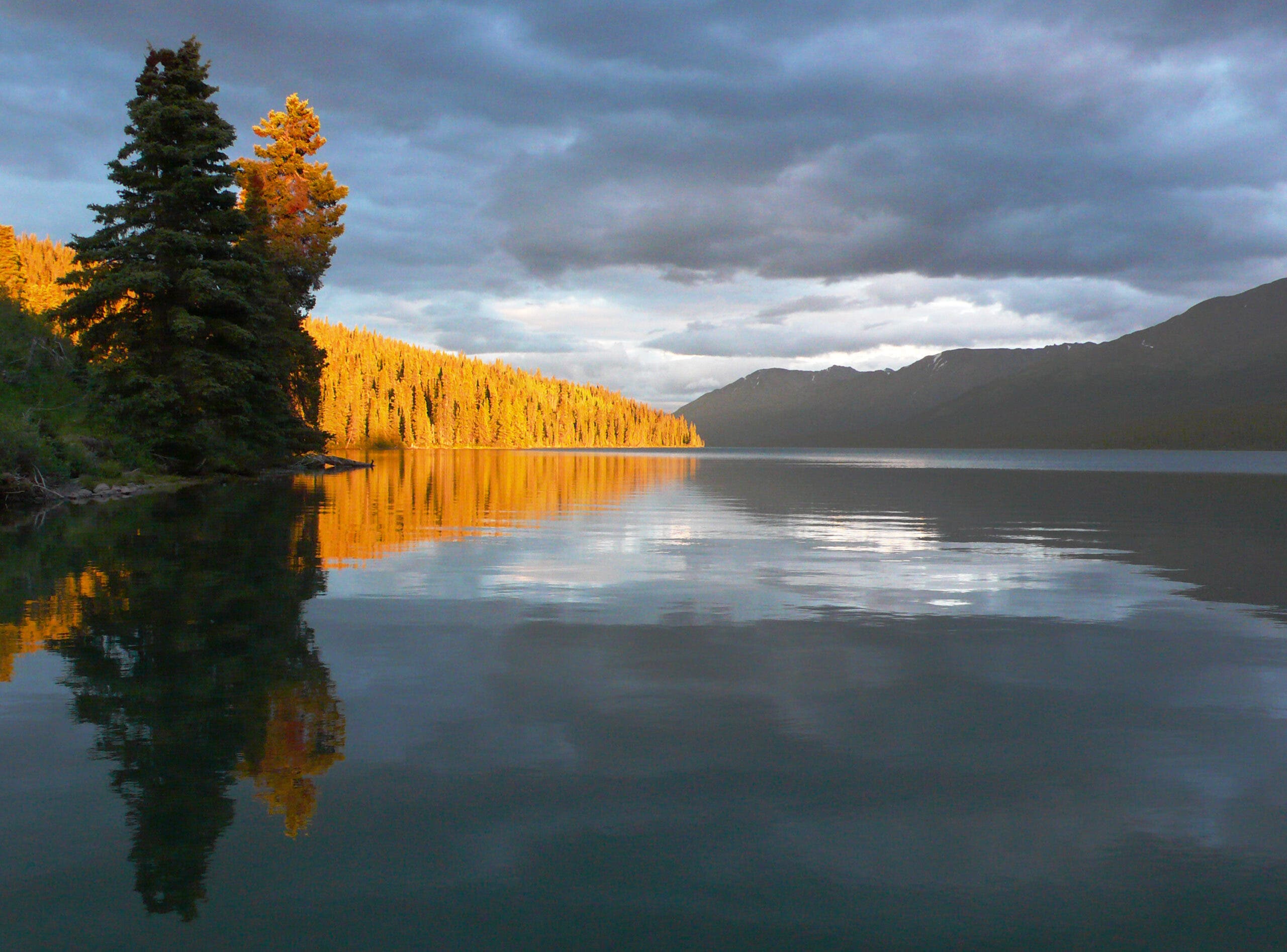
The water looks like Ovaltine, but the backdrop of 8,200-foot Mt. Will offers a sensational tableau of horned, glaciated peaks. I settle on the sponge near a stony beach and cook up delicious Mountain House spaghetti, seasoned with a lot of soreness, a touch of contentment, and a dash of fear. I watch the gilded peaks get bloody, and even spy a rainbow sprouting from the top of one.
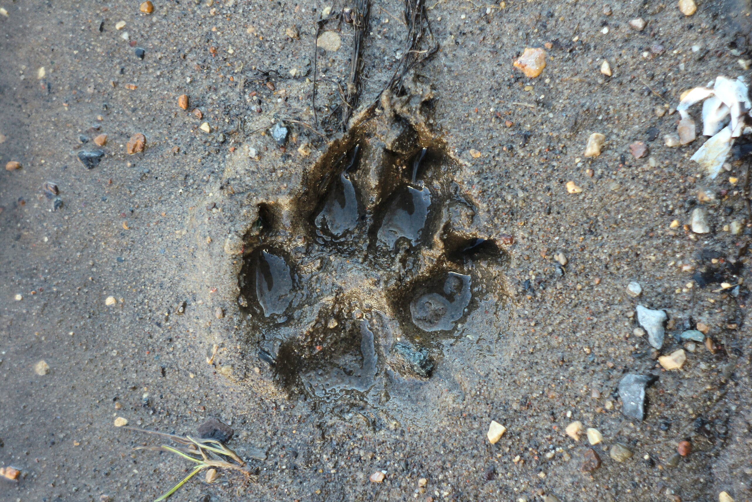
In the night, just as the words in my book begin to blur together, I hear padding right outside my tent, followed by rustles in the bushes and reeds. I stir and catch the muffled drumming of eight, 16, maybe 20 pairs of paws. I scan outside with a headlamp, but I only catch the briefest shadows whooshing into the black. In the morning, I find fresh wolf tracks flanking my tent.
I stop rushing to reach arbitrary waypoints, and make my goals incremental and environmental: 20 yards to a fairy pond spangled with mushrooms for lunch; 200 steps to a nap-ready rock under a canopy of whispering birch
After a leisurely morning with cowboy coffee, I follow the wolf tracks down the shoreline. They lead to a fallen tree that offers a natural bridge over a 3-foot-deep, speeding, sapphire creek. After some poking around on the other side, I pick up the wolf path again. It’s like a twisty dog run cut into the green moss, ducking under branches and weaving between trees, charging up slopes. The path is clear, but it turns into a wolf-high tunnel when the woods close in. I’m starting to figure out the ways in which game trails match their makers.
Nearby, I grab a moose path: Easy to follow, deeply cut, and punched out with soup bowl-size potholes. Moose bodies cut a wide swath at head height, creating face space in the willows. But they always seem to end up in a bog. Caribou trails are similar, but begin in the forest and proceed steadily uphill to gain the plateaus. Stone sheep cut switchbacks into dare-you-to-follow territory—good for getting out of the tangled lowlands, great for suicidal cliff diving. All the game trails have one thing in common: They vanish often, with no reason. I find one multispecies turnpike paved with short grass and pine needles, wide and flat enough for a Cadillac. It lasts about 200 yards.
ADVERTISEMENT
Walking a mile in this terrain is more brutal than I’d imagined. But I start adapting. I survive my bog dive. I stop rushing to reach arbitrary waypoints, and make my goals incremental and environmental: 20 yards to a fairy pond spangled with mushrooms for lunch; 200 steps to a nap-ready rock under a canopy of whispering birch. My body aches from knees to neck, so I lie down under a giant spruce, sinking into a moss mattress. I even let the mosquitoes settle and fall asleep counting them.
You don’t have to bear-wrestle the frontier to taste Spatsizi—that’s my choice. This is reinforced as I recuperate at Cold Fish Lake, in a Spartan, red-roofed cabin maintained by the park service, which costs less per night than a burger and a beer and lies a few miles from Bug Lake (I get a horse shuttle in for the pot roast).
I spend two days at Cold Fish, exploring honest-to-goodness trails that radiate like spokes outward into Spatsizi. I tramp 7.5 miles into Airplane Valley, a dayhike sampler of waterfalls, high tundra, flowers, and craggy ridges. A scramble up a scree slope affords a peek back down onto the route that occupied my wilder journey. Another trail leads up and above to the Spatsizi Plateau, an expanse of sub-Arctic tundra barricaded from Pacific rains and snows by mountains. I climb to the 6,500-foot plateau to catch a 10:15 p.m. sunset and arrive just in time to see a herd of caribou blink out into the indigo. I stay until my toes get cold.
ADVERTISEMENT
With my wilderness reservoir full and the sufferfest over, I can’t help but luxuriate in this cabernet-and-cabana phase. But I already find my mind drifting back to the hardest miles. It takes mere hours of relative comfort for a glow of romance to creep into the memories.
When I take off from Cold Fish Lake with Clay Collingwood in his buzzing Cessna 206, I pause from gaping at Spatsizi’s royal basins through the windows to watch a video I took on my phone. It’s a video I’ll watch and rewatch in the months to come.
In it, I’m following fat moose knuckles cast into the gray-sand beach as Arctic grayling rise and spool ripples on a lake set against a cooling sun. I’m still 3 long miles from the cabins. The upward, two-note howl of a loon cuts into my halting dialogue (something about “bushwhacking hell”). Mosquitoes dart into the foreground like hummingbirds.
The hiker on the screen has vacant, wandering eyes and a sunburned face smeared with a mixture of peat, bugs, and blood. I look at him and I think: I want to go there.
ADVERTISEMENT
Northwest Field Editor Ted Alvarez’s March 2013 story, “The Truth about Bears,” was nominated for a National Magazine Award. It also involved a wonderfully hellish hike.
Trip Planner: Spatsizi Plateau Wilderness Provincial Park
Park Info Check before you go, as trails and ATV roads are subject to frequent washouts and are unmaintained. Reserve backcountry cabins at Cold Fish Lake ($20/night) in advance.
Season August and September for fewest bugs and most animals
Outfitter The Collingwood’s Spatsizi Wilderness Vacations offers full-service, guided adventures. Custom services available.
Floatplane Alpine Lakes Air flights into Bug Lake and Cold Fish Lake can accommodate 850 pounds of people and gear (a steal for groups).
Can I drive? While there’s no road access to the park, it’s possible to hike there via the McEwan Trail. The entire journey from the trailhead near the small community of Iskut takes 4 to 5 days and ends at Cold Fish Lake.
The Skills: Plan an Expedition
You finally cleared the decks for that long-awaited dream hike. But whether this season brings a straightforward John Muir Trail thru-hike or a complicated Alaska bushwhack, big expeditions require a lot more planning than a three-day weekend. The legwork you put in now can make your adventure safer, more enjoyable, and more likely to succeed. Here’s how to pull off that life-list trip and plan an expedition, courtesy of Steve Howe.
Scout the Route
- Dig deep for beta. Cross-reference topos, Gaia GPS, aerial photos, and elevation profiles to find the best route, resupply points, and campsites. Online trip reports, photos, and forums (like whiteblaze.net for the AT) also provide hard-to-find info.
- Set realistic mileage goals. Big-trip loads are heavy and day-after-day travel exhausting. For off-trail routes, consider 1 mph an average pace; for on-trail trips with a 12-day load, perhaps 1.5 mph. In Alaska and the Pacific Northwest, budget two weather days a week.
Mark Your Calendar
- Circle trip dates, plus the lead-up period. Include start/finish dates for tasks like grocery shopping, packing, and training. Highlight deadlines for permit applications, airline or shuttle booking, and holidays that might stop mail on a resupply day.
- Create a trip itinerary, with daily mileages, start/stop points, cruxes, etc.
Prep Your Gear
- Create a packing list Start assembling your kit a few months early to identify gear that needs attention, like a DWR treatment on a tired rain shell. If hiking the cusp of spring or fall, you might need different gear at the trip’s end than at the beginning.
- Package meals in waterproof bags Mark them Day One, Day Two, etc. so you don’t raid all the chocolate on day three. Allot more food for tail-end days when you’ll be ravenous. To keep food weight and bulk low, pack calorie-dense foods like nuts, peanut butter, and cheese. Although vacuum-packed cheeses may separate into oil and curd, they’ll keep for weeks in cool mountain weather.
- Assemble a first-aid kit Include beaucoup dressings, blister-repair items, and any medications.
- Locate gear shops near your start point, or resupply points on a trip where you can access them. Ask the proprietors in advance to hold some fuel for you.
- Carry an emergency signaling device Buy or rent a PLB, SPOT, or sat phone, and consider rescue insurance. Two options: American Alpine Club membership or Global Rescue.
Get Fit
- Stick religiously to a training program. Strains and sprains, often due to poor conditioning, tank many trips. Trail running, especially on hills, combined with leg- and back-strengthening exercises, prepare you the most efficiently. For legs, think squats, hamstring curls, and calf raises. We’ve assembled a good, basic program here to help you get expedition-ready and prevent injuries.
Begin Final Countdown
The day before hitting the trailhead, check all of your preparations and critical gear one last time.
- Call rangers, pilots, or outfitters for conditions, and check recent trip reports and weather (try weatherunderground.com and forecast.weather.gov).
- If a bush pilot’s flying you into a remote region, overfly your route on the way to your dropoff, especially if it’s rarely hiked. This can save you if your plan was conceived with disastrous overconfidence.
- Have a backup plan, plus prescouted bailout points along the route, in case weather or injury derail you.
- Leave an itinerary with a family member and also a local outfitter, ranger, or pilot, since they’ll probably be the first to know if you miss your due-back date.