Updated December 3, 2024 06:09PM
These Trails Have Some of the World's Worst Weather. Here's Why You Should Go Anyway.
Get in touch with your wild side in some of the worst weather the Lower 48 has to offer.
'iStock'
We should be telling you to plan your next hike for a warm, sunny day—but where’s the adventure in that? Besides, the most memorable hikes are rarely the picture-perfect ones. If you want real solitude, and a raw, visceral experience in nature, go where everyone else refuses. These six weather-beaten, heat-blasted, totally untamed trails are the perfect place to get started.
A word of caution: To have these experiences, you need to be prepared. That means bringing enough food, water, layers, navigation equipment, and other protective gear to stay comfortable in the conditions you expect.
And in bad weather, the most dangerous part of your journey is rarely the hike itself. In fact, studies attribute more deaths in national parks to motor vehicle accidents than to wildlife, avalanches, heat, or cold exposure combined. So, if you’re on a quest to face down nature’s extremes, bring a dependable vehicle. In places where high precip or low visibility is likely, you’ll also need all-weather tires, like Nokian WR G4s. (Keep in mind that all-season tires are often a misnomer; they’re designed for dry roads and generally safe driving conditions. All-weather tires, on the other hand, are significantly more responsive, especially on wet roads, and are both more durable and more resistant to high temperatures than winter tires.) Other musts: good brakes, a road map, and some driving savvy.
That said, have at it. Here are seven Lower-48 trails that will test your courage and give you an adventure you’ll really remember.
ADVERTISEMENT
1. Badwater Basin, Death Valley National Park, California

Come summer in Death Valley, temperatures regularly tick up to 120 degrees, and asphalt roads can get hot enough to melt sneakers. For that reason, most authorities recommend exploring the valley between November and March, especially if your body isn’t already acclimated to extreme heat.
For the ultimate experience, we recommend starting your adventure in the barren salt flats of Badwater Basin. At 282 feet below sea level, it’s the lowest point in North America. Try the 17-mile out-and-back up rugged Sheep Canyon and camp mid-way at Gold Valley—the 3,500-foot elevation there makes for slightly more tolerable sleeping temps.
2. Tuckerman Ravine Trail, Mount Washington, New Hampshire

Known for record-breaking wind speeds (think over 230 mph) Mount Washington’s reputation precedes it. Even during the summer, temperatures at the summit regularly drop below freezing, and fresh snow has been recorded there every month of the year. Credit the 6,288-foot peak’s location right in the crosshairs of three different weather systems.
You can access the summit via a handful of trails, including the classic Tuckerman Ravine Trail, which packs over 8,000 feet of elevation change into one 7.8-mile roundtrip. Weather looking really bad? No worries—you can drive to the top and view the gusts through the windows of the summit weather observatory, which is open to the public mid-May through mid-October.
ADVERTISEMENT
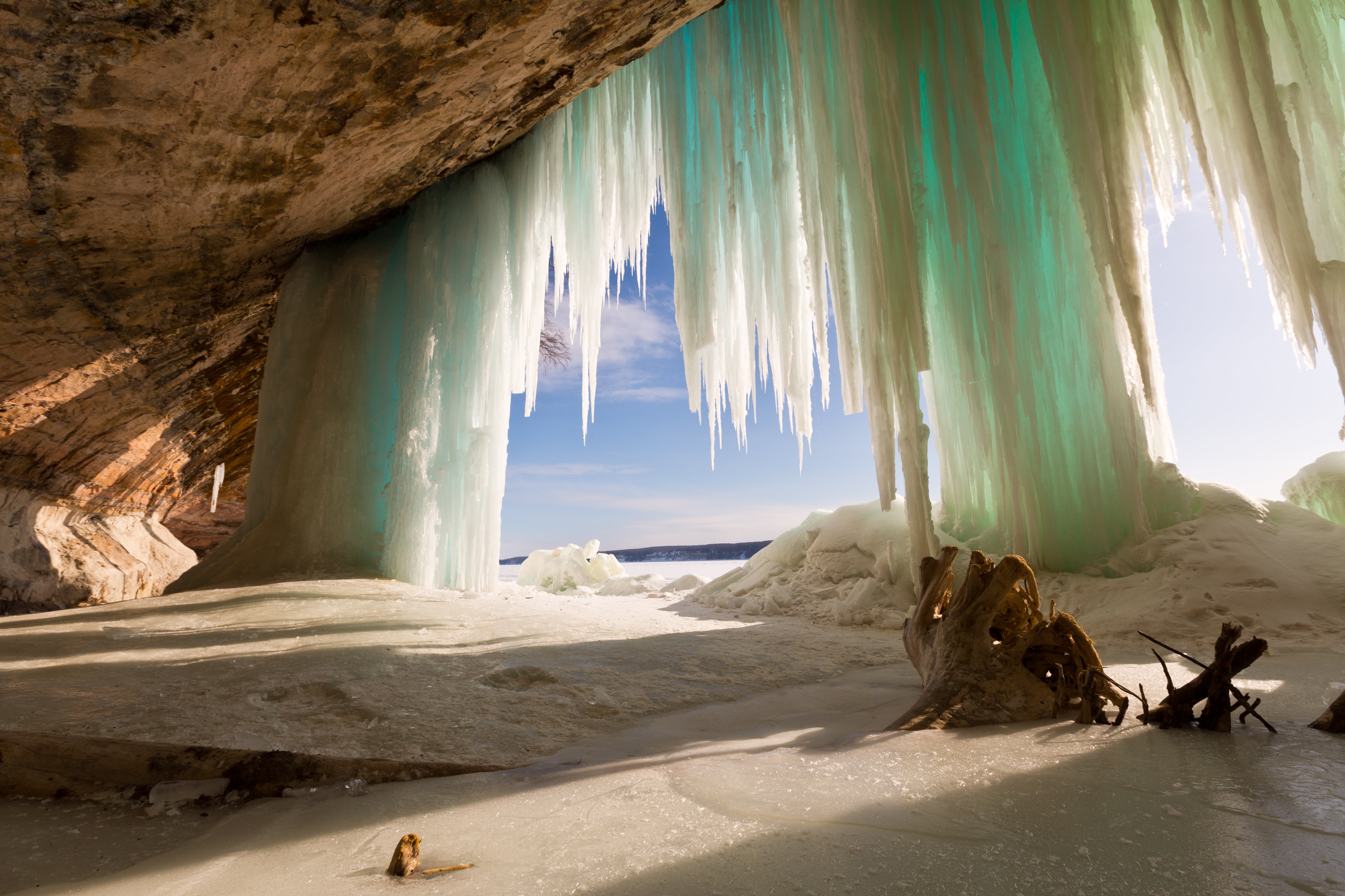
3. Lakeshore North Country Trail, Pictured Rocks National Lakeshore, Michigan

Pictured Rocks National Lakeshore may sound like a post-card picnic destination, but don’t be fooled: Its proximity to Lake Superior means unpredictable weather and chill, wet winters. Be prepared for fog, wind, and up to 200 inches of snow each winter.
Fortunately, the colder months also freeze the park into a crystalline sculpture garden. For views of frozen pillars and curtains of ice, hike the 0.2-mile trail to Munising Falls or wander beneath the ice-plated Pictured Rocks Escarpment between Munising Falls and Sand Point. (The road between Munising Falls to Sand Point is plowed in winter.) Want to go farther? The plowed road ends but the adventure continues along the lakeside North Country Trail. Bring traction and flotation.
4. Hoh River Trail, Olympic National Park, Washington

Thanks to its position between the Cascades’ rain shadow and the stormy Pacific Coast, the Hoh Rainforest gets up to 170 inches of rain per year—enough water to completely submerge a single-story house. Summer means drier weather, but for the true rainforest experience, hike the Hoh River Trail in spring or fall when a drenching is inevitable.
The trail starts beneath moss-curtained trees at the Hoh Rain Forest Visitor Center. Follow the path its full 17.6 miles to the base of Mount Olympus (which gets a whopping 260 inches of precipitation every year), or turn around at any point for a shorter out-and-back.
ADVERTISEMENT
5. Atchafalaya River, Atchafalaya National Heritage Area, Louisiana

Gators. Maze-like channels. Cypress Trees. If you can get past the brutal southern Louisiana humidity, there’s plenty of adventure to be had in the Atchafalaya Basin. As the biggest river swamp in the USA, the basin is best navigated by canoe or kayak. Paddle a section of the Atchafalaya River, or choose your own adventure by connecting any number of lakes and canals (bring a GPS unit and a good map).
Gators make you nervous? There are terrestrial trails here, too; try nearby Lake Fausse Pointe State Park for a selection of nature trails between 0.75 and 3.3 miles in length.
6. Alkali Flat Trail, White Sands National Monument, New Mexico

White Sands National Monument might just be the femme fatale of the whole U.S. national parks system. Sure, the pure white dunes look serene and otherworldly under a sunset, but almost every season has its dangers. Want to go in winter? Freezing sand is a recipe for hypothermia. Summer? Monsoon season. Spring? Sandstorms. Oh, and don’t forget the scorpions, rattlesnakes, and nearby active missile range.
Pick your poison and plan to hike the 5-mile Alkali Flat Trail, which offers mountain views and plenty of dune time. Target a day with minimal wind to avoid getting blinded or disoriented by the coarse, white gypsum sand.