Updated July 18, 2025 12:29PM
20 Fall Hikes You Can Do Right Now
Catch the best of the season all across the country.
'Ian Sane'
Unless you live in south Florida, there’s a fall show happening near you, or there will be soon. Case in point: these 20 spectacular autumn hikes, which mix fall leaves with everything from beaches to waterfalls. Pick your region and get going.
West
Mt. Constitution Loop, Moran State Park, WA
Aim for the sweet spot between summer crowds and winter cold on this 6.7-mile loop to the highest point in the San Juan Islands. With the first dusting of snow settling over the Cascade and Coast Ranges and bright red berries decorating the island’s madrones, the views are gorgeous near and far. On Orcas Island, Park at Mountain Lake, then brace your quads for the 1,500-foot, steep eastern face of Mt. Constitution. The climb winds through an evergreen and madrone forest until you reach the bare rock summit. Take a moment away from the mountain-to-sea panorama to look for glacial score marks on the summit rock before making you way to the stone watchtower that crowns the peak. This replica of a 12-century Russian watchtower was built in the 1930s by the Civilian Conservation Corps; the roads and bridges throughout Moran State Park were built by the same crew. Cross the parking lot behind the tower to continue your loop, dropping down to Twin Lakes before returning back to Mountain Lake via the dense woods of the island interior.
Trailhead 48.6569, -122.8180. Take your car on the ferry from Anacortes to Orcas Island; there is almost no public transportation on the island. Season Year-round; fall is best for foliage but can be rainy, and winter is best for clear mountain views and no crowds. Permit Discover Pass ($35 for a year or $11.50 for a day)
Lake Ingalls, Alpine Lakes Wilderness, WA
Lake Ingalls comes alive in fall, when the larches and the alpine shrubs put on a colorful show. The bright blue lake is nestled beneath 9,416-foot Mt. Stuart, the second-highest non-volcanic peak in Washington. The first turn comes only 0.4 mile past the trailhead; right will take you 4.1 miles to Lake Ingalls. Watch for mountain goats as you climb from the junction to Ingalls Pass. The views start early, Fortune Pass and the Esmeralda Peaks towering high above the occasional evergreen clusters. At the pass, though, the world opens up below you. A wide swath of green sweeps from the edge of the pass, threaded with streams and larch groves, until it brushes up against the cliffs that hide Lake Ingalls from view. Take a left at the pass to take the easier route to the lake. Wind around the scree slopes before hopping enormous rock slabs down to the lakeshore to find your lunch spot.
ADVERTISEMENT
Trailhead 47.4367, -120.9369 Season Summer is crowded, but fall is when this hike really shines; pack extra layers for the cooler temperatures. Permit Vehicle permit ($5 per day at trailhead) and wilderness permit for campers (free, self-issue at trailhead; no dogs allowed and no camping within half a mile of the lake).
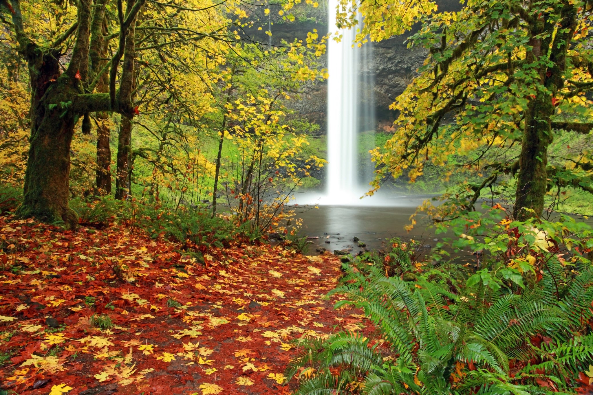
Trail of Ten Falls, Silver Falls State Park, OR
When Oregon’s high country turns icy and the beaches are scoured by 10-foot swells, turn to the forest for your nature fix. On the Trail of Ten Falls you’ll find more than just the namesake cascades—the canyon itself is beautiful, draped in moss and old-growth hemlocks and Douglas firs. The 10 magnificent waterfalls are just icing on the cake. Start from the South Falls Lodge trailhead and follow the Rim Trail to the spur for the North Falls viewpoint. Get your first good look down the canyon here, where falls slip over vertical walls of ancient lava. Return to the main trail and take the second right on the Canyon Trail. Wind beneath the viewpoint and behind 136-foot North Falls, spray drifting to cling to your rain jacket. Continue another mile to Twin Falls, split into two by a midstream rock. Winter Falls doesn’t always flow this time of year, but you can still check the spur trail to investigate. Cross behind more falls to the wooden viewing platform for Drake Falls. The trail loops back to the original Canyon Trail junction to bring you back to your car.
Trailhead 44.8787, -122.6565 Season Year-round, but expect crowds in summer. Permit Parking permit ($5 per day). Pets are not allowed on the Canyon Trail.
Parker Mesa Overlook, Topanga State Park, CA
Fall typically brings the year’s clearest skies to Southern California, and this 6.7-mile round-trip hike above Santa Monica Bay makes the most of the visibility. Even Catalina Island is visible through the crisp air, a blue hummock against the bluer sea. Take in the view—and the scent of sagebrush—from a 1,500-foot oceanfront ridge. With only 375 feet of elevation gain along the ridge traverse, the hike to Parker Mesa Overlook is an easy, rolling walk with views almost from the trailhead. Start at the Trippet Ranch trailhead, then follow the East Topanga Fire road from the south side of the parking lot. Take a right at the T-junction at mile .25, emerging from scattered oaks to the open ridgetop. Canyons open to either side of you in dizzying drops, Santa Ynez to the left and Topanga to the right. Follow the ups and downs of the ridgeline for another 2.65 miles, then turn right and hike the last half mile to the overlook. The Santa Monica Mountains spread all around you from this high point, dropping to the bay in slanted green canyons.
ADVERTISEMENT
Trailhead 34.0933, -118.5879 Season Year-round, but fall and spring have the best foliage and temperatures. Dogs are not allowed on park trails or fire roads. Permit None
Lake Blanche Trail, Twin Peaks Wilderness, Utah
It’s hard to beat a trek through bright yellow aspen groves on the way to an alpine lake. And if that lake is in one of the most scenic sections of the Wasatch Mountains? You’ll never want to leave. Fortunately, you’re allowed to stay overnight at Blanche Lake, an alpine pool nestled beneath Sundial, Dromedary, and O’Sullivan Peaks. Spur trails lead from your basecamp by Blanche to Florence and Lillian Lakes, a pair of small tarns about a quarter mile away that make great day trips. If you’re going in October plan for possible snow; you might get perfect sunshine, but you could also get the first blizzard of the season. Start at the Mill B South Fork trailhead in Big Cottonwood Canyon. The 7-mile round-trip Lake Blanche Trail starts at the east end of the lower parking lot and is well signed. Watch for striations on the rocks as you wind up the canyon, left by the glaciers that carved the valley.
Trailhead 40.6331, -111.7233 Season Summer and fall; crowds decrease in the fall, but keep your route-finding skills ready in case of a sudden snowstorm. Permit None; no camping allowed within 200 feet of trails, lakes, or streams. Limit of 10 campers per group.
Mazatzal Peak Loop, Mazatzal Wilderness, AZ
Only 50 miles from Phoenix, the Mazatzal is at once easily accessible and astonishingly remote. With more than 25,000 acres of wilderness stretching from evergreens to saguaros and few visitors in any season, this corner of Arizona is a perfect fall retreat. Time your trip for peak hardwood colors in mid- to late-October to catch the leaf show. Fall here has the best weather, too; October is well past monsoon season, with comfortable daytime highs in the mid-70s. Watch for black bears amid the fall foliage on the 15-mile Mazatzal Peak Loop, a tough dayhike that rolls through more than 3,000 feet of elevation gain on its way around the mountain. Start on the forested Barnhardt Trail, then turn left on the Mazatzal Divide Trail at mile 6. At mile 9 take a left onto the Y Bar Trail and return back to your car. The views of the Mazatzal Peak Escarpment and the south fork of Deadman’s Creek are ample reward for the effort. Split the route with a campsite at Windsor Saddle (mile 9) for a weekend getaway, but remember to bring your own water.
ADVERTISEMENT
Trailhead 34.0928, -111.4219 Season Year-round, but best in fall and spring, when daytime temperatures stay comfortable and there’s less chance of sudden storms. Permit None
Rainbow Vista Trail, Valley of Fire State Park, NV
Anyone who’s ever stared into an evening campfire knows there’s more to see than red and orange. Watch long enough and you’ll see white and even blue dance among the embers. In the fall, get a similar fiery color show on the Rainbow Vista Trail, a short but remarkable loop through sandstone towers and narrow canyons in the Nevada desert. From the trailhead, head east on the sandy trail; bright red-orange towers frame the draw on either side in impossible wind-carved formations. The desert opens up less than a quarter mile from the parking lot, in a broad sandy bowl between ridges; turn left here to start the main 1.6-mile loop. As you hike along the edge of the rocks more ridges rise into view, striped pink and white and even blue in the far Muddy Mountains. Partway around take a slight detour up a narrow canyon to the Fire Canyon Overlook, the perfect spot for a lunch break. The overlook drops away into a bright orange jumble of towers and tiny arches stretching to the blue ridges of the horizon. Return to the loop trail and follow it back to the first junction, then hook a left to return to the parking lot. If you’re hooked on the desert and need some more miles, try the Pinnacles Loop or the Prospect Trail.
Trailhead 36.4508, -114.5155 Season Fall and spring have the best weather and temperatures. Permit entrance fee ($10); dogs must be on leashes no longer than 6 feet.
Thurman Creek/Meadow Loop, Harriman State Park, ID
Fall means one thing in the Idaho mountains: elk. Find bugling herds—along with other wildlife like bears and moose—in the meadows at Harriman State Park. Nearly 300 elk congregate in these meadows every year; hikers can watch the love-struck bulls challenge each other on this 4.7-mile route connecting the Thurman Creek Loop and Meadow Loop trails. Start at the Ranchview parking lot, taking a left almost immediately on the River Trail. Enjoy views of the Tetons for the .3 mile to Railroad Ranch, then turn left on the ranch loop. In 0.4 mile stay straight to continue on to the Thurman Creek Loop. Meander through lodgepole pine stands and open meadows, keeping an eye out for elk, for another 1.6 miles, then turn right; continue onto the Meadow Loop. This is the prime trail for elk spotting, so keep your camera handy. Follow the loop back to Railroad Ranch and the River Trail to return to your car.
ADVERTISEMENT
Trailhead 44.3340, -111.4659 Season Spring, summer, and fall; fall is best for wildlife spotting. Permit $5 per day vehicle pass; pets are not allowed on park trails.
Bunsen Peak, Yellowstone National Park, WY
German chemist Robert Bunsen’s pioneering work on geysers earned him a peak name here in Yellowstone National Park, even though he did all his fieldwork in Iceland. There are no active geysers on the hike up Bunsen Peak, but it does showcase some of the park’s most exciting natural history. The 4.6-mile hike starts on the remains of an ancient volcano, winding gradually up a hill through lodgepole pine groves. Partway up the hill the views really start, looking back towards Golden Gate Canyon. Just before mile 1 the trail curves around the southwest side of the peak for some of the best scenery of the day, with views of Swan Lake Flats and the Gallatin Range. See if you can pick out Electric and Antler Peaks on the horizon. After your photo break return to the north side of the mountain and a burn left from the 1988 Summer of Fire before pausing again below Cathedral Rock for views of Mammoth Hot Springs and Fort Yellowstone. After this the climb really starts, ascending switchbacks through talus for another 0.9 mile to the USGS marker at the summit.
Trailhead 44.932, -110.728 Season Late spring to fall; summer can be hot and crowded, so go in the fall to get the trail to yourself. Permit Yellowstone Park entrance fee ($35 per vehicle, good for 7 days); dogs are not allowed on park trails.
Central
Prairie Loop and River Trail, Afton State Park, MN
ADVERTISEMENT
Gold-bleached grass and red oaks sweep across this riverside haven, only 45 minutes from Minneapolis. With more than 20 miles of hiking trails spread through almost 3,000 acres of forested valleys and prairie bluffs, this easy escape has plenty to offer. Fall brings turning leaves and crisp air perfect for long views over the prairie and the Afton Alps; the park’s oak forests spread a blazing red canopy over the riverside. Peak colors are around mid- to late-October. For a 3-mile hike through all the park’s ecosystems, follow the North River Trail along the St. Croix River, keeping an eye out for hidden beaches, then turn north on the prairie loop. A slight incline takes you through a mix of pine and oak until you reach the top of the bluffs. Stay on the loop until you reach the North River Trail turnoff again, then retrace your steps to the parking lot.
Trailhead 44.8547, -92.7747 Season Year-round, but bring plenty of layers in fall, and be prepared for snow and frigid temps in winter. Permit MN State Parks Permit ($35 for a year or $7 for a day); dogs are allowed on the trails but not the beach.
Schramm Park Loop, Schramm Park State Recreation Area, NE
Hike through an ancient seabed on this 3-mile loop through Schramm Park State Recreation Area, a quiet retreat on the Platte River. The path wanders in and out of the hardwood forest between dips along the half-mile-wide Platte. Underbrush covers most of the rocks here—300 million-year-old limestone and shale from a long-ago shallow sea—sending you through a tunnel of leaves with each turn away from the riverbank. The highlight of the loop is a suspension bridge curving high through the canopy of a forested ravine. Take advantage of the bird’s-eye view to watch for bald eagles and whip-or-wills. Partway through the loop is a meditation shelter, perfect for a moment of solitude. After you finish the loop, detour to the park’s east entrance to search for Paleozoic coral and brachiopod fossils in the exposed cliffside.
ADVERTISEMENT
Trailhead 41.0260, -96.2536 Season Year-round, but best in fall when the leaves change Permit Vehicle permit to enter park ($6 daily for Nebraska vehicle, $8 out of state)
Palo Duro Canyon, Palo Duro Canyon State Park, TX
Fall is the perfect time to visit America’s second largest canyon, a 120-mile sandstone chasm in the Texas Panhandle. This desert scrubland can reach 120F in the summer, but October brings cooler temperatures and much more comfortable hiking (still carry plenty of water). The panhandle’s flat grasslands drop away to 800-foot cliffs of orange and red sandstone as bright as any autumn leaf show on the Lighthouse Trail, a 5.4-mile out-and-back to a sandstone tower that wouldn’t look out of place at Arches National Park. The trail is deservedly popular, so go early or late if you want a better chance of solitude; a narrow ridge of sandstone below the tower overlooks 20 miles of jagged canyonlands, with mesquite and juniper clustered around the Prairie Dog Town fork of the Red River far below.
Trailhead 34.9508, -101.6681 Season Fall and spring are best for more comfortable hiking temperatures. Permit Park entrance fee ($8 per person per day)
Seven Hollows Loop, Petit Jean State Park, AR
Picture this: stone arches, hidden seasonal waterfalls, and cacti. It sounds more like a national park in Utah than a hike in Arkansas, but you can find them all at Petit Jean State Park. Discover the best of this park on the Seven Hollows Loop, named for the seven small streams that each carved its own hollow into the rock. The trail dips in and out of four of the seven hollows, climbing the rocky bluffs between them for open views between scattered pines to the surrounding hills. The first time you ascend from the deep forest of the hollows to the open meadows of the ridgetops, it’s easy to get distracted by the wider view, but don’t forget to look down at the prickly pear cacti that grow amid the rocks in these open areas. Time your trip just after a rainstorm to see a waterfall; take a spur trail right at mile 2.1 and follow the cliff base .1 mile to a secluded grotto. At high water, a low cascade drops to a broad pool between the bluffs.
ADVERTISEMENT
Trailhead 35.1153, -92.9446 Season Year-round, but the weather is better in fall and late winter; spring tends to be rainy. Permit none
Pinhoti Trail and Blue Mountain, Cheaha State Park, AL
Fall is the best season for Alabama hiking—no longer muggy but with temperatures still hovering around comfortable. For views, hills, and a bit of fall color try Blue Mountain, branching off from the lower Pinhoti Trail. With almost 1,200 feet of elevation gain in just over 6 miles, this trail has a great scenery-to-sweat ratio. Wind through deep forest as you start off, crossing a broad, shallow creek with a colorful pebbled bed, then really get into the climb. Luckily there’s a nice view at the top, across rolling forest and distant blue hills. A large, grassy area just before the summit likely harbors ticks, so make sure to check yourself and any pets when you get home. Return the way you came.
Trailhead 33.4710, -85.8067 Season Year-round; fall has the best temperatures and weather Permit park entrance fee ($5 per day)
East
Sentinel Mountain, Baxter State Park, ME
Find a horizon of the classic Maine peaks in all their fall splendor on this 6.2-mile out-and-back. Easier and lower elevation than Katahdin and its neighbors—think less chance of getting caught in a serious shoulder-season storm—Sentinel Mountain gives you panoramic views of the changing leaves without a leg-burning climb. Start at the Kidney Pond day-use parking lot. The Sentinel Mountain Trail begins with a counterclockwise curve around the lake; watch for moose and beaver in the fiery foliage. Follow the trail to the ridgeline and your first views of the day. Right as you reach the ridgeline there’s a junction for a .6-mile loop around the mountain. Go left first to find a lunch spot on the open summit ledges, with views of the Penobscot River and the 100 Mile Wilderness, then complete the summit loop and return to the day-use area the way you came. There is a stream crossing and a number of wet areas on the trail, so waterproof boots are recommended.
Trailhead 45.8934, -69.0486 Season Summer and fall; fall has less crowds and more colors. Permit Entrance fee for out-of-state vehicles; dogs are not allowed.
ADVERTISEMENT
Sleeping Beauty Mountain, Lake George Wild Forest, NY
Don’t start your winter hibernation just yet—fall is sweeping into the Adirondacks in a kaleidoscope of red, green, and orange. Find the best of the Adirondacks on display at Sleeping Beauty Mountain through October, when the birch, ash, and maples turn colors. For this 6.8-mile out-and-back, start at the Hogtown trailhead and hike 1.5 miles down a 4WD road (often closed to cars) to Dacy Clearing. From Dacy Clearing, follow yellow trail markers until mile 2.2, then turn right and follow the blue markers for the 1,038-foot climb to the top of Sleeping Beauty. Reach the best viewpoint of the hike at mile 3.4, with Crane Mountain to the west, Killington to the east, and Lake George glittering far below. The actual summit is 0.4 mile farther but doesn’t have much in the way of views. Retrace your steps to the car. Fall is one of the driest seasons in this region, so take advantage of the sunny skies before winter weather arrives.
Trailhead 43.5314, -73.5656 Season Spring, summer, and fall; fall has the best weather and lacks the summer crowds. Permit None
Tri-Valley Trail, White Clay Creek State Park, DE
The cheerful burble of a forest creek is the melody of White Clay Creek’s fall soundtrack. Add bright, swirling, water-borne leaves and the Tri-Valley Trail, a 4.5-mile out-and-back that follows White Clay Creek, and this is as close to an autumn music video as it gets in the Delaware woods. Look up for bald eagles and turkey vultures before heading to one of the creekside beaches to see if you can spot some of the stream’s abundant trout. The trails here roll with the hills, so expect a bit of a workout as you wind your way through the park. Don’t have enough time to make the full hike? Turn the out-and-back into a short loop by turning right on Hopkins Road when you reach the end of the trail and crossing the bridge back to the parking lot.
Trailhead 39.7495, -75.7708 Season Year-round, but fall and spring have the most interesting foliage Permit park entrance fee ($4 daily in-state, $8 out-of-state)
ADVERTISEMENT
Sugarloaf Circuit, Shenandoah National Park, VA
Find mountain laurels mingling with chestnut, poplar, and red oak in the hills of Virginia. Peaking in mid-October, the color show here is nothing short of extraordinary; the birches and poplars flare brilliant yellow against flushed red oaks, with orange sumac and maples scattered between. Even the understory gets in on the performance, with Virginia creepers flaring scarlet against their autumn scaffolds and dogwoods scattering an unexpected maroon-purple through the forest. The Sugarloaf Circuit brings you up through the forest to a viewpoint overlooking Shenandoah’s hills, moving from a close-up view of the colorful leaves to a wide vista. Park just south of Hogback Overlook, at the parking lot at mile 21 of Skyline Drive, and follow the blue-blazed trail from the south end of the parking lot. At mile 3.3, tackle a short ascent to the summit of Hogback Mountain and panoramic views, then descend back to the parking lot to close the 5.6-mile loop.
Trailhead 38.7618, -78.2778 Season Fall and spring have the best temperatures Permit Entrance fee ($30 per vehicle)
Table Rock Trail, Table Rock State Park, SC
Sheer granite domes aren’t just endemic to the Sierras. Hike the East’s answer to the West’s rocky core at Table Rock State Park, where oak forests and scattered pines crowd against spectacular cliffs. For open summit views, serene forest, and a thigh-burning 2,000 feet of elevation gain try the 7.2-mile round-trip Table Rock Trail. Starting at the park’s nature center, take Carrick Creek Trail until the junction with red-blazed Table Rock Trail. Turn right to begin the 3.6-mile climb to the summit of 3,124-foot Table Rock Mountain through red-leafed oaks and pale gold hickory. Rocky ledges on the mountaintop make a perfect lunch spot. Keep an eye out for the peregrine falcons that nest on the park’s cliffs; re-introduced to the area in the 1980s, the falcons have nested here every year since 1989.
ADVERTISEMENT
Trailhead 35.0317, -82.6996 Season Year-round; summer has more crowds, while fall and spring have the best foliage and temperatures. Permit $5 park admission
Sitton’s Gulch Trail, Cloudland Canyon State Park, GA
A collection of waterfalls amidst dense deciduous forest is the highlight of this 6-mile out-and-back in Cloudland Canyon. Start by dropping down the near-vertical canyon walls. The steep descent (and steep ascent during your return trip) keeps many hikers away, leaving you to explore the canyon in relative solitude. Start from the east rim on the Waterfall Trail. Detour down the first turnoff to 60-foot Cherokee Falls, plunging in a sheer silky veil, then return to the trail and descend to even taller Hemlock Falls, dropping 90 feet through the bright scarlet and yellow canopy. Cross a wooden bridge over Daniel Creek soon after returning to the main trail; this is the official start of the Sitton’s Gulch Trail. Drop even farther to a creek bed of moss and ferns, with occasional waterfalls through tumbled boulders. Cross through a section of bright deciduous forest around mile 2.25; another quarter mile brings you to a parking area and your turnaround point.
Trailhead 34.8599, -85.4844 Season Year-round; fall is best for good weather and comfortable temperatures Permit $5 parking fee