Published December 2, 2011 04:49PM
Select a Safe Route: Avalanche Terrain Travel
Recognize these avalanche-risk signs and learn how to choose routes that avoid them.
'Avalanche Terrain (By Supercorn)'
Watch the Weather | Study the Snowpack
Travel Safe in Avy Terrain
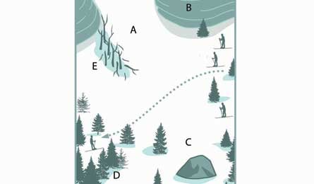
>> Steep slopes Large slides typically start on slopes between 30 and 45 degrees (A). Shallower angles usually don’t initiate slides, and sheer steeps (B) don’t hold much snow, so huge movement is less likely. Most people overestimate slope angle: Measure it accurately (see Outfit for Survival). On steep angles, move quickly, traverse the slope’s upper part, travel gently (don’t stomp), spread groups out, and be aware of obstacles and terrain traps below you (C), which may block your escape route.
>> Bowls and gullies Steep, open slopes and bowls, as well as ravines, are likely avalanche zones. Safer areas include ridge crests, thick forests (D), wide valleys, and windward slopes (that don’t have big snow deposits hanging above). When crossing danger zones is unavoidable, have the entire group watch the active skier until he reaches a safe zone. Don’t assume terrain is stable if one skier crosses safely.
>> North-facing aspects In winter, generally opt for south-facing slopes. Because the sun melts and condenses snow, they’re more stable. North-facing slopes tend to be more powdery, but often have unstable layers. The opposite is true in spring, when temperatures rise: South-facing slopes warm, resulting in heavy, wet slides. And north aspects—now undergoing slower, stabilizing freeze-thaw cycles—may be safer.
>> Cracking snow Be on alert if you see cracks in the surface, you hear a whumph sound, the surface feels hollow, or you see snowballs rolling downhill. These are all avy indicators.
>> Previous paths If there’s old slide evidence—like a big, open chute through a forest, broken trees (E), or a debris pile, avoid the trap and move quickly out of the danger zone.