Utilize the Top Backcountry Apps

'wired_technology_app_illo_200x170'
Get Current Conditions
Put together your own portable forecast service.
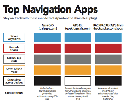
BACKPACKER GPS Trails Pro
($5; iPhone, Android; backpacker.com/apps) can overlay five weather maps (Doppler radar, cloud cover, wind, temp, ocean temp) on your trip route ($30/year for weather).
Don’t be surprised by the shifting tides. TideTrac ($3; iPhone, iPad; tidetrac .com) lets you save offline tide tables for any location, then reference them during coastal hikes or paddling trips.
Lay your phone at the angle of the snow and the Mammut Safety app (free; iPhone; mammut .ch/en) uses a clinometer, compass, and altimeter to estimate avy risk—no data connection needed.
Lingo
POI marker or Waypoint A digital signpost for key points on your map
Offline map A map that doesn’t require a data connection to be viewed
GPX The universal language in which GPS data is saved so it can be shared
Geotagged Media associated with a geographically referenced location
Gain Expertise Fast
Identify peaks, plants, and more: Preload your phone with these top apps.
There’s no need to bust out the topo map and ruler if you download Peak Scanner ($2; iPhone; itunes.com), which tells you the names of nearby peaks and your distance (vertical and horizontal) from the summit.
Take a photo of a leaf with Columbia University’s Leafsnap (free; iPhone, iPad; leafsnap.com) and the app’s visual recognition software will spit out the species (data connection required).
Send a photo of an unidentified plant or animal to iNaturalist (free; iPhone, Android; iNaturalist .org), and your picture will be uploaded to a public forum where other users can help you solve the mystery.
Identify more than 900 North American bird species by color, flight style, shape, or song with the iBird Lite Guide to Birds app (free; iPhone, iPad; ibird.com).
