Trip Finder: West

'California's Lost Coast. (Ed Callaert)'

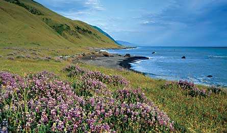
California’s Lost Coast. (Ed Callaert)

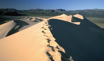
Death valley’s Eureka Dunes. (Larry Carver)

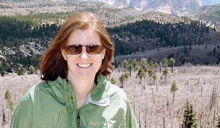
Reader expert Sara Benson. (courtesy)
DAYHIKES | WEEKEND | MULTIDAY
DAYHIKES
SHORE TRAILS Papakolea Beach Trail, HI
The four-mile, one-way trek to Papakolea Beach near Mauna Loa, on Hawaii’s Big Island, ends with a cliff scramble into the bowl-shaped beach—and a wide ocean view across green sand. “Seriously—green sand,” emphasizes Inga McFadden (above). The rare color is caused by the semi-precious mineral olivine, eroded from the volcano looming above the beach. Papakolea is one of only two green-sand beaches in U.S. territory—the other is in Guam. (808) 974-4250
ALL-STAR GEOLOGY Eureka Dunes, CA
In 1994, Death Valley expanded to include Eureka Dunes, a bone-white sea of sand that rivals Colorado’s Great Sand Dunes as North America’s tallest. The rugged, remote South Eureka Road dead-ends at the parking lot. Blaze a trail 680 feet up the highest dune, and listen for “singing sand”—a bass-note boom that happens when sand avalanches off the highest dunes. “I’ll never forget the sound of that sand,” says Jason Krantz, of Sacramento, California. nps.gov/deva
MONSTER FLORA Mt. Pipiwai Trail, HI
The four-mile, round-trip Pipiwai Trail in Maui’s Haleakala National Park travels through dense, pristine rainforest dotted with waterfalls pouring into clear swimming pools. Hike over the roots of an enormous banyan, past tulip trees sprouting bright yellow and orange blossoms, and through an eerie bamboo forest before ending at Waimoku Falls, which pours 400 feet down a black-lava rock face. Take a dip, but wear shoes, says Brian Abeyta of Denver: Sharp, slick lava surrounds the thigh-deep pool. nps.gov/hale
DAYHIKES | WEEKEND | MULTIDAY
WEEKEND
SHORE TRAILSTahoe Rim Trail, NV
Most hikers shoehorn this 23.1-mile stretch of the Tahoe Rim Trail from Tahoe Meadows to Spooner Summit into an overnight. Add an extra day to explore side trips like the short Christopher’s Loop spur at the trail’s midpoint, which leads to a lofty cliff perch with an expansive view of the sparkling waters. “It’s the best view of the lake you can get without being in an aircraft,” says Angeline Perdue, of Reno, Nevada. Going south, camp at Marlette Peak, at mile 13, and North Canyon, at mile 18. tahoerimtrail.org
ALL-STAR GEOLOGY Half Dome, CA
Crowds and permits be damned, glacier-carved, 8,836-foot Half Dome still tops your West Coast life list. Since everyone else thinks so, too, take an extra day and break up the nearly 17-mile round-trip hike by camping at Little Yosemite Valley—seven miles from the summit. Nab a $10 backcountry permit (available four months in advance). Leave camp about three hours before dawn and you’ll be back with sunrise photos while the ants are still standing in line, waiting to see the view. nps.gov/yose
MONSTER FLORAMt. Charleston Trail, NV
Gnarled, twisted bristlecone pines even look their age. See the 3,000-year-old Raintree, the oldest living thing in Nevada, three miles into the 20-mile Mt. Charleston National Recreation Trail loop, which winds through the biggest colony of bristlecones in the Intermountain West. Continue on to bag the three highest mountains in southern Nevada—11,000-foot Mummy, Charleston, and Griffith Peaks—all in one day. No permits necessary: Camp by springs pouring from each peak. fs.fed.us/r4/htnf
DAYHIKES | WEEKEND | MULTIDAY
MULTIDAY
SHORE TRAILSMattole Creek to Shelter Cove, CA
The Lost Coast stymied road builders, but not readers—not that it’s easy. The 26 miles from Mattole Creek to Shelter Cove “is one of the most difficult flat hikes you’ll ever do in your life,” says Dave Miller. Conquer difficult scrambles, often-fierce weather, and confounding tides, and reap the reward: black-sand beaches, possible whale sightings, and daily surprises, like mist rising off the ocean from Big Creek at sunrise. Ultralighters: Look for driftwood shelters. blm.gov/ca/st/en/fo/arcata/kingrange/index.html
ALL-STAR GEOLOGY Mauna Loa, HI
Hiking this trail’s scarred lava flows and otherworldly craters is as close to a moonwalk as you’ll get without riding a rocket. “There are places on Mauna Loa where you see nothing but black lava and blue skies,” says Inga McFadden. Skip the tent: The 43-mile out-and-back in Volcanoes National Park has cabins at miles 7.5 and 19 (check availability at the visitor center). Local tip: Hike 2.5 miles beyond the last “Summit Cabin” to reach the true summit and peer down into the yawning, 1.5-mile-wide caldera. nps.gov/havo
MONSTER FLORAHigh Sierra Trail, CA
The 72-mile High Sierra Trail offers the most complete tour of Cali’s botanical wonders, starting with the world’s most massive organism (sequoia) in the Giant Forest and ending with tiny purple clusters of ornate skypilots sprouting in between talus above 13,000 feet on Mt. Whitney. You’ll summit the highest point in the Lower 48, but former ranger Sara Benson (above) says the technicolor wildflower vistas at Bearpaw Meadow (mile 11) might be your most vivid memory. nps.gov/seki
THE EXPERT
Inga McFadden, 50, lives in Holualoa on Hawaii’s Big Island, where diverse trails mean “today I could climb a peak in a down jacket and snow boots or hike the coast in a swimsuit.”
Ex-Kings Canyon ranger Sara Benson, 35, of San Luis Obispo, California, hikes the High Sierra Trail each year. “Flora and fauna tell a story as you walk,” she says. “It’s an outdoor classroom.”