Published January 9, 2009 12:19PM
Trek Copper Canyon Rim to Rim
Hike North America's deepest canyon
'0109_theworkscopper_445x260'
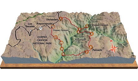
Numbers don’t lie: With a depth of more than 5,500 feet and 10,000 square miles of canyons, northwest Mexico’s La Barranca del Cobre (translation: Copper Canyon) is deeper, wider, and longer than our Grand. And don’t expect well-marked trails, or search-and-rescue crews. Instead? Plunging vistas, soaring stone spires, and a menagerie of parrots and jaguars. See Copper Canyon’s undisputed highlights on a 38-mile loop with 20,000 feet elevation change from the village of Divisadero to Pamachi on the east rim, and back, over seven days.
Do it
At Divisadero, check out the phenomenal views at El Ojo de la Barranca (the Eye of the Canyon), a precipitous arroyo that dives bullet-straight 5,000-plus feet to the river (1, see map above). From there, head southeast to a long, rocky ridge that separates El Ojo and a large arroyo called Rurahuachi. The trail snakes along the ridge and also switchbacks into the Rurahuachi for about seven miles to the Urique River (2), transitioning from conifers up high to figs, ceiba trees, and bamboo below. Sleep on the river’s white-sand banks; the next day, take a side trip a couple of miles upstream to the Great Bend (3), where the canyon veers 90 degrees. Then hike two miles downstream from camp–fording the knee- to waist-deep river several times–to the Pamachi trailhead and camp (4).
Swim in the warm water and scout the mudflats for tracks from bobcats, otters, and coati (a large desert cousin of the raccoon). On day three, your quads will be en fuego as you huff about five miles and 4,000 feet up the brush-filled arroyo to a spring (5), where you’ll find sweeping views of enormous rock formations–fins, pinnacles, and scalloped walls. The next day is easy, with just two to three miles and 1,200 vertical feet to go before Pamachi (6): Expect a greeting committee of village children. Hike about three more miles up the rim and camp by a stream (7). On day five, lengthen your trekking poles for a 5,000-foot descent over five miles through beautiful hanging valleys and past ranchitos tucked on the cliffside path locals call “Camino Real.” Watch, also, for native Tarahumara engravings on exposed rock. Ford the river and camp a little upstream from a boulderfield containing house-size blocks (8).
ADVERTISEMENT
Day six is relaxed–after climbing about 1.5 miles up an arroyo, dip into some hot springs (9), and then continue for another mile to a grove of orange trees and camp (10). On day seven, gain a long ridge after three miles (11) and hike it for another three–those 4,000 vertical feet bring you to Areponapuchi’s hot showers, cold margaritas, and views of the Sierra Madre (12).
Go Guided
Copper Canyon Trails offers an eight-night trip (six in the backcountry, two at hotels before and after) for $1,275 per person. coppercanyontrails.org
Gear
Pack a three-season sleeping bag, waterproof stuff sacks to keep gear dry on river crossings, a patch kit for sleeping pads (thorny plants), a Spanish dictionary, your remedy of choice for traveler’s diarrhea, and gifts such as glass beads, sewing needles or reading glasses for the Tarahumara.
Season
Late November to mid-March. Early summer is bake-oven hot, and mid-July to mid-September is monsoon season.