Published July 22, 2013 05:54PM
Backpacker's Top 3 Quad-Burning Trails
You're in mid-season shape; reap the rewards on some of the country's steepest hikes.
(Photo: ericfoltz via Getty Images)
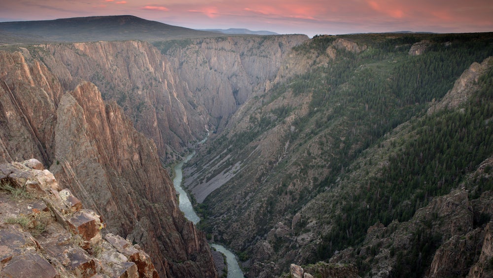
S.O.B. Draw: Black Canyon of the Gunnison NP, CO
Descend one of the country’s deepest gorges.
Think you’ve seen deep, sheer, and narrow? Not until you go rim-to-river in this mind-bendingly steep gash. The 48-mile-long canyon swoops to a depth of 2,722 feet and stretches just 40 feet across at its narrowest point. Venturing down is more controlled fall than hike, but you’ll get in-your-face views of Colorado’s tallest cliff, gold-medal trout fishing, and a bottom-up perspective few ever see. From the North Rim trailhead, skirt the chasm’s edge for .3 mile before the descent begins in earnest. There’s no marked trail, so pick your way through the hippo-size boulders, avoiding both hidden cliffs and the route’s legendary, 8-foot-tall poison ivy (long sleeves and pants recommended). You’ll finally exhale when you hit bottom—1.8 miles and 1,800 vertical feet later. Press another .8 mile downstream to the wider, wilder second beach. Rest up: Tomorrow, your way out is straight back up. (970-641-2337; nps.gov/blca)
The way From Grand Junction, take CO 50 29 miles to 92 E; go 30 miles to Crawford. Link Dogwood Avenue, 3850 Drive, and Black Canyon Road (closed in winter) 13 miles to the North Rim Campground.
ADVERTISEMENT
Mt. Defiance: Columbia River Gorge, OR
Climb from river to summit in the Cascades.
The Gorge doesn’t mess around with leisurely approaches, and the 5.2-mile ascent from river level (150 feet) to the top of 4,959-foot Mt. Defiance might be king among the canyon’s precipitous trails. The reward: A trio of waterfalls cascading over stones gone electric-green with moss, expansive views of five Cascade volcanoes, and serious bragging rights. From the Starvation Creek trailhead, track west on Mt. Defiance Trail 413 to reach three waterfalls in your first mile. Brace yourself for the real haul: The trail now ascends mercilessly up 15 switchbacks and a ridgeline, gaining 4,500 feet in about 4 miles. The trip’s best views lie on Defiance Cutoff Trail on the peak’s western flank: Mts. Rainier, Adams, St. Helens, Hood, and Jefferson line up on the horizon. Follow the cutoff trail to tag the summit (where the vistas are obstructed by looming trees); return the same way. Overnight option: backpacker.com/mtdefiance. (541-308-1700; fs.usda.gov/crgnsa)
The way From Portland, take I-84 E about 52 miles to Starvation Creek SP.
ADVERTISEMENT
Appalachian Trail Loop: Bigelow Range Preserve, ME
Ride an undulating ridge to four peaks.
The trails linking Bigelow’s wind-strafed peaks are uniformly rocky and ridiculously vertical—earning them a reputation as some of the toughest miles in the AT’s toughest state. On this 13.6-mile loop, you’ll top out on four summits, logging nearly 4,300 feet of elevation gain. The payoff: endless views over green-carpeted peaks. From the trailhead on Stratton Brook Pond Road, take the AT north almost 2,000 vertical feet and 4.3 miles to Horns Pond, stocked with brook trout. (Got two days? Bunk at the free Horns Pond shelters .2 mile east.) Now the peakbagging begins: Follow the AT east to knock off 3,792-foot North Horn via a .2-mile spur and its twin, 3,805-foot South Horn. Trace the ridge another 2.2 miles east to your high point: 4,145-foot West Peak, where you’ll enjoy an eagle-eye view of island-speckled Flagstaff Lake and peaks up to 100 miles away. Drop steeply to Bigelow Col, then press on .4 mile to bag 4,000-foot Avery Peak. Backtrack to the Col and resist gravity down the Firewarden’s Trail (you’ll lose about 1,300 feet in the first .8 mile); continue 3.8 miles to Stratton Brook Road. Head west .6 miles back to your car. (207-778-8231; mainetrailfinder.com/trails/trail/appalachian-trail-bigelow-preserve)
The way From Kingfield, drive 18 miles north on ME 16/27 to the AT trailhead.