Published July 31, 2009 06:48PM
Top 3 Perfect Substitute National Forests
Get national park-caliber scenery without crowds (or entry fees!) in these dead ringers for Great Smoky Mountains, Zion, and Yosemite.
'Dixie NF, UT (Whit Richardson)'
DIXIE NF, UT | NANTAHALA NF, NC | TOIYABE-HUMBOLDT NF, CA
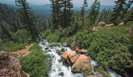
DIXIE NF, UT
Meet Zion’s wild neighbor.
The canyon walls of the Virgin River Valley look impossibly sheer from 5,785-foot
Angel’s Landing, one of the most popular hike-up peaks in Zion National Park.
And they look even more imposing 50 miles northeast in the 2-million-acre Dixie
National Forest–where you’ll be 3,000 feet higher and not have to elbow
for the best camera angles. Take the Virgin River Rim Trail along a 9,000-foot-high
cliff past gnarled bristlecone pines, bony hoodoos, and red-rock amphitheaters.
In 3.5 miles you’ll reach your turnaround point at the Cat’s Den, a jumbled
collection of feline-shaped sandstone atop the Markagunt Plateau, home to the
headwaters of the Virgin River and an eagle-eye view of Angel’s Landing to the
southwest. In summer, pack three quarts of water.
Refuel
Park ranger’s choice: prime rib at Milt’s Stage Shop in Cedar City. (435) 586-9344
The Way
From Cedar City, head east 10 miles on UT 14 to the Duck Creek Visitor Center.
Turn onto FS 30370, and go one mile to a left onto FS 30054. Turn left to reach
Cascade Falls trailhead.
DIXIE NF, UT | NANTAHALA NF, NC | TOIYABE-HUMBOLDT NF, CA
ADVERTISEMENT
NANTAHALA NF, NC
Hike to a deserted bald.
If you want iconic Smokies scenery–an orange sun lighting the famous haze
in shades of purple and blue–without sharing, the comparatively people-free,
531,000-acre Nantahala National Forest awaits across Fontana Lake to the south.
Ninety miles from the park border lies Tusquitee Bald, a grassy, 5,200-foot
crown where you can spy the folded ridges of the Nantahala Mountains stretching
into the clouds. Get there via a calf-busting five-mile out-and-back under a
canopy of red oak so thick the sun rarely touches bare ground. Take the Far
Bald Spring Trail and gain nearly 2,000 feet in 1.9 miles to link to the Fires
Creek Rim Trail. You’ll track half a mile through thinning forest to the Chunky
Gal Trail and a short scramble to the summit, the tallest of three balds on
a two-mile-long open ridge.
Refuel
Area hikers rave about the lemon- pepper local rainbow trout at Cottage Deli
in Hayesville. (828) 389-8473
The Way
From Hayesville, make lefts onto Tusquitee St., then Fires Creek Rd. Then go
4.5 miles to a right on SR 1344, which leads to the trailhead.
DIXIE NF, UT | NANTAHALA NF, NC | TOIYABE-HUMBOLDT NF, CA
ADVERTISEMENT
TOIYABE-HUMBOLDT NF, CA
Climb into the Sierra Nevada’s quiet side.
Just north of Yosemite National Park’s RV-lined roads, the nine-mile Buckeye
Trail sneaks into a tight gorge between the Flatiron and Buckeye ridges on the
park’s northern boundary. You’ll trek from sage-dotted flatlands into pine forests
for 2.5 miles and rise to a view of 11,000-foot granite peaks leading into the
park. At mile four, you’ll come to the first of five creek crossings. Meadows
of knee-high Indian paintbrush bordered by aspen stands lie between each stream.
Four miles past the last crossing, you’ll reach a talus slide called The Roughs.
Boulder-hop along a marked path half a mile to reach 9,650-foot Buckeye Pass,
with views into five Yosemite canyons.
Refuel
Head to Rhino’s Bar & Grill in Bridgeport for a fiery hot Nitro burger.
(760) 932-7345
The Way
From Bridgeport, take Twin Lakes Rd. seven miles to FS 017. Turn right and go
three miles to a left into Buckeye Creek Campground. The trailhead is in the
last camp loop.