Published November 16, 2009 12:41PM
Top 3 Ansel Adams Hikes and Reader Photos
The legendary shooter once said that photographs were "usually looked at, seldom looked into." Take a look into three hikes that inspired some of Ansel Adams greatest photos, and take a few pictures yourself.
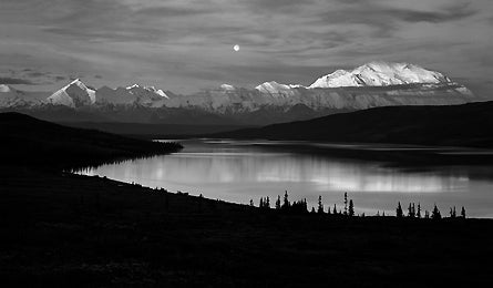
'Dnali NP, AK (Photo Credit: Brett Baunton)'
Yosemite NP, CA | Pecos Wilderness, NM | Denali NP, AK
Yosemite NP, CA
See the Valley from atop north dome.
Adams delighted in shooting Yosemite Valley–from above. See why on this classic 9.2-mile out-and-back to North Dome and its picture-perfect vantage point 3,500 feet above the valley floor. From Tioga Road, descend the North Dome Trail for .75 mile to Porcupine Creek. Cross the creek, then in just under a mile reach two trail junctions. Go right, then left, to continue south on the NDT. At mile three, detour a quarter-mile on a spur trail to the 20-foot Indian Rock arch. Back on the NDT, continue along Indian Ridge. Stay left at one last wooded junction, then arrive at the big finish: North Dome’s 7,542-foot crown at 4.6 miles. Shot tip: Highlight Yosemite Valley’s expansiveness by filling the bottom third of your frame with granite icons like Half Dome and El Capitan, leaving the rest to the California sky.
ADVERTISEMENT
Upload
Mariposa’s Happy Burger has the Mother Lode Burger (three patties, four bacon strips) and Wi-Fi. happyburgerdiner.com
The Way From its junction with Big Oak Flat Rd., take Tioga Pass Rd. 26.5 miles east through Porcupine Flat Campground to the trailhead on the right.
Yosemite NP, CA | Pecos Wilderness, NM | Denali NP, AK
Pecos Wilderness, NM
Shoot a seldom-seen alpine lake.
The snow-crowned mountains in Adams’s photo, “Moonrise, Hernandez, New Mexico,” lie in the southernmost reaches of the Sangre de Cristo Range. Trek deep into those peaks on this 9.5-miler to a never-crowded lake surrounded by 12,000-foot peaks. From the trailhead at the end of NM 161, pick up the Serpent Lake Trail. After .3 mile of easy doubletrack, you’ll scramble over rocks and roots as the trail climbs 1,300 feet to a junction at 3.4 miles. Turn right to reach the small, jewel-like pool in about half a mile. Since traffic in this part of the wilderness is light, the shore is surrounded by dense meadow grasses, marigolds, and other wildflowers. Shot tip: On shore, kneel down with your camera so the water fills most of the frame. Angle upward to get flowers, lake, 12,835-foot Jicarita Peak, and the sprawling sky overhead.
ADVERTISEMENT
Upload
Get a latte and internet at Taos’s Wired? Cyber-Cafe. wiredcoffeeshop.com
The Way
From Taos, drive 3.5 miles south on NM 68 and turn left onto NM 518. Head 29 miles to FR 161. Turn right and take the gravel road 4.5 miles to the trailhead.
Yosemite NP, CA | Pecos Wilderness, NM | Denali NP, AK
Denali NP, AK
Bag (a shot of) america’s tallest peak.
In the 1940s, Adams embarked on several federally funded trips to shoot national parks and monuments. It’s a majestic portfolio, to be sure, but his Denali shots stand out above all others. Set up your own winner on this march to 5,417-foot Mt. Healy. You’ll gain 1,700 feet in 2.5 miles on the Mt. Healy Overlook Trail (start across the road from the visitor center on AK 3). Steep switchbacks begin at treeline; bear right at an intersection just beyond to reach the summit. The Great One dominates the entire southwestern horizon. Shot tip: Emphasize the mountain’s mass by centering Denali and making sure the peak touches, but does not fill, the top third of your frame. Clouds help define elevation.
ADVERTISEMENT
Upload
Head to the College Coffeehouse in Fairbanks for Wi-Fi and live music. collegecoffeehousefairbanks.com
The Way
From Healy, take AK 3 (the George Parks Highway) 12 miles south to the Denali Visitor Center.