The Works: Snowshoe the Sierra

'theworksnowshoemap_445x260'
California’s White Mountain range really lives up to its name in the fourth season. It bristles with a mantle of virgin snow covering high-desert peaks and features something almost oxymoronic: an uncrowded, novices-welcome fourteener. White Mountain (14,246 feet), the third tallest in the state, offers unparalleled views of the Sierra Nevada amidst 4,000-year-old bristlecone pines and the occasional bighorn sheep. It’s a worthy excursion year-round, but winter is our pick for scenery and solitude. The way to do it: a 59-mile, seven-day snowshoe from Westgard Pass (7,313 feet) to the summit and back.
Do it
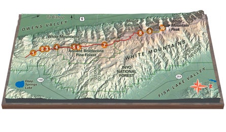
The route ascends gently up the White Mountain Road (closed and snow-covered in the winter, but easily followed) for 22.7 miles through piñon pines and junipers. Take day one easy, with lunch at the lushly wooded Pinyon Picnic Area, mile 3 (1); camp at the wind-sheltered and picnic table-equipped Grandview Campground, at mile 6.4 (2). On day two, check out the Sierra Vista Point at mile 7.7 (3) for stunning views of the Sierra Nevada stretching north and south like an accordion. At mile 9.9 (4), you’ll reach Schulman Grove (elevation 10,100 feet), home to 4,700-year-old Methuselah, the oldest non-clonal tree on the planet. Three miles later, continue north past the intersection with Silver Canyon and Wyman Canyon Roads. A grove of the eerily beautiful bristlecones–their spiral trunks sculpted by ice and sand–opens up at mile 13.9 (5). Pitch your tent just beyond at mile 14.1 (6) amidst the ghostly pines. (Enjoy this rare treat now, because camping in the bristlecone forest isn’t allowed in the summer.) At the Patriarch Grove (11,500 feet, mile 18.3) (7), crane your neck at the area’s largest bristlecone, the Patriarch; a quarter-mile loop on the Timberline Ancients Trail travels past it. On night three, camp at the Barcroft Gate trailhead (12,000 feet, mile 22.7) (8), the normal summer starting point. From here, emerge onto a broad ridge and follow an old road past quartzite talus and limestone outcroppings. At mile 24.7 (9), researchers at the 12,470-foot Barcroft Research Facility study meteorology and the effects of high altitude on human physiology year-round. At mile 29.7 (10), you’ll crest the summit and its dramatic views of the Owens Valley, 9,000 feet below, and the thirteeners of the Whites Range, such as Mt. Dubois (13,559 feet) and Mt. Montgomery (13,441 feet) to the north. You’ll share the summit with North America’s highest permanent research station, the Summit Laboratory, a small stone cabin that houses four scientists. Return the way you came, camping nights four, five, and six at the same sites you used on the ascent.
Guides
The Sierra Mountain Center (sierramountaincenter.com; 760-873-8526) leads customized winter trips into the White Mountains and Sierra. Prices start at $395 per person per day.
Permits
Camping in the Ancient Bristlecone Pine Forest requires a free permit. Get one at the White Mountain Ranger Station (760-873-2500; fs.fed.us/r5/inyo).
Season
Snow levels are best come January, so start planning now.