The Works: Hike Vermont's Long Trail

'(Photo by Tim Seaver)'

(Photo by Tim Seaver)

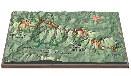
Map by International Mapping Associates
Ben & Jerry’s pints, Burton snowboards, and Maple syrup may be Vermont’s most famous exports, but long-distance hiking was born here, too. The 272-mile Long Trail (LT), completed in 1930, is the country’s first thru-hikers’ trail.
From its southern terminus on the Vermont-Massachusetts border, the Long Trail traces the spine of the Green Mountains en route to Canada, passing archetypal landscapes of rolling pastures, red barns, and grazing Holsteins.
You can go end to end in a month, but we have the beta for the perfect week–a 50.3-mile trek that encompasses the LT’s best scenery and highest terrain.
Do it
From Camel’s Hump Road near Waterbury, take the steep Monroe Trail (1) 3.1 miles through beech and white birch to the white-blazed LT. Turn north for an easy 0.2-mile ascent of 4,083-foot Camel’s Hump (2), a granite pulpit in a congregation of maples. Look west to see sparkling Lake Champlain, Vermont’s largest lake. Descend 3.5 miles to Bamforth Ridge Shelter (3).
The next day, follow the ridge a half-mile north (look over your shoulder for a southern view of the Green Mountain range) before dropping to Duxbury Road (4). Follow the road 3.3 miles west to cross the Winooski River Bridge (5) to Jonesville, the LT’s lowest elevation at 326 feet. From here, follow blazes two more miles to the Duck Brook Shelter (6), with space for 12.
On day three, top off your water in Duck Brook before embarking on a rolling 9.8-mile day leading over 3,725-foot Bolton Mountain (7) to the Puffer Shelter (8), built with materials hauled over the mountain by 100 volunteers. In the morning, enjoy a 1.4-mile descent to the wooded top of Mt. Mayo (9).
Continue five miles to the Wallace Cutoff 10), a spur on the western slope of Mt. Mansfield leading 0.1 mile to the Butler Lodge (11), with bunks for 14 ($5/hiker). On day five, maples give way to an exposed ridge leading to the 4,393-foot Mt. Mansfield. The ridgeline resembles the silhouette of a human face. You’ll cross the Forehead, then pass a granite obelisk (yes, the Nose), then rise and fall along the Upper and Lower Lip before reaching the Chin (12), the true summit (Vermont’s high point). From here, it’s a 2.5-mile descent into Smugglers Notch (13), a steep valley used to transport Canadian booze across the border during the prohibition era. Head 2.7 more miles to the Sterling Pond Shelter (14).
The next morning, ascend Sterling Ridge 1.2 miles to Madonna Peak (15), then roll another three to Whiteface Mountain (16). Continue 2.9 miles to Bear Hollow Shelter (17), at mile 46.4. Feeling spry? Descend 3.9 miles to VT 15, where the trail leads to the Long Trail Tavern (18). Long Trail Ale is on tap; camping out back is free.
Season
Early October, with kaleidoscopic foliage and zero bugs, is pure heaven. Plus, shelter crowds are smaller than in summer.
Gear
Hit Umiak Outdoor Outfitters in Stowe for last-minute supplies. (802) 253-2317
Shuttle
Use the Green Mountain Transit Agency (gmtaride.org; click on “Route 100 Commuter”) to get from Morrisville Center (11 miles from Long Trail Tavern) to the Waterbury Park and Ride (seven miles from your car). Contact the Green Mountain Club (802-244-7037) for a list of Trail Angels willing to drive you to and from the bus stops.