Published February 24, 2010 02:31PM
The Peak: Mt. Tamalpais, CA
At Mt. Tam you'll find wilderness solitude with Pacific views only 20 miles from San Francisco. Plus, there's a beer garden.
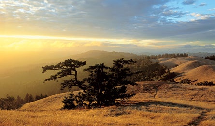
'Mt. Tam's sunset from Bolinas Ridge. (Ed Callaert)'

Mt. Tam’s sunset from Bolinas Ridge. (Ed Callaert)

Coast Redwoods (Kirkendall-Spring)
You don’t need a million-dollar penthouse to savor the best view in San Francisco. Just hike to Mt. Tam, as locals call this iconic peak. Twenty miles north of the city, it’s the centerpiece of a 6,300-acre pocket of undeveloped woodland, lakes, and open meadows laced with more than 50 miles of trail and capped by one of the best views on the West Coast: a 360-degree panorama of the mighty Pacific, San Francisco Bay, and, on a clear day, the Sierra Nevada a couple hundred miles to the east. But the view isn’t even its best feature. What is: the opportunity for a real wilderness experience amidst redwood forests, grasslands, and rugged coast within minutes of one of the most densely populated areas of the country.
ADVERTISEMENT
With a road to the summit, the top can get busy, but you can nab the same view from its uncrowded ridges on this stout 14.8-mile out-and-back. From the Dipsea trailhead in Mill Valley, climb 671 stairs into the heart of Mt. Tamalpais State Park. Continue under a canopy of coast redwoods paralleling Muir Redwoods National Monument. From here, the trail climbs steadily to Windy Gap before losing elevation to the base of Cardiac Hill. This long (and aptly named) climb tops out at 1,360 feet, where views of Stinson Beach and the Pacific open up.
Enjoy a gradual downhill to Stinson Beach and its perfect arc of soft sand (picnic, anyone?), then retrace your steps. Just before reaching the trailhead, sidehike .7 mile on the narrow Sun Trail to a paved path leading to the Alpine Tourist Club, built in 1914 by German immigrants.This private club opens its outdoor beer garden on weekends until 5 p.m.
The Best…
Mountain biking
Welcome to fat-tire ground zero. Locals love linking Samuel P. Taylor State Park and Loma Alta Open Space Preserve via the Bay Area Ridge Trail for 10.6 miles of fast singletrack and killer scenery.
App
Download Tom Harrison’s Mt. Tam map to your iPhone ($5, apple.com). It’s as detailed as the paper version—and cheaper.
Campsite
Hawk Camp Campground in the Marin Headlands is centralized for hiking and biking. It’s a 2.7-mile hike or ride on the Bobcat Trail from Bunker Road. Free. (415) 331-1540, nps.gov/goga