Published September 30, 2008 07:13PM
The Fix: Shenandoah National Park
Catch this national park's brightest fall foliage on a short stroll or an all-day epic.
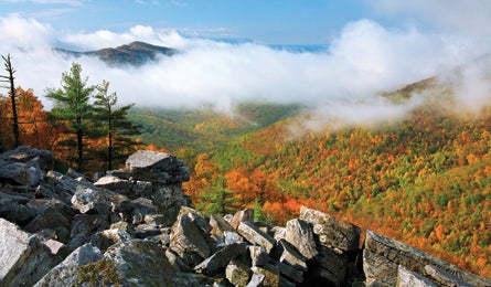
'Some of the best leaf peeping awaits in Shenandoah. (Pat & Chuck Blackley)'
3 Hours
Descend to Hidden Waterfalls
For a four-mile loop with a splash, park just north of milepost 50 on Skyline Drive at Fisher’s Gap Overlook. Cross Skyline and start hiking at the silver-banded trail marker, descending 1.2 miles to Rose River Falls. Turn right onto the blue-blazed Rose River Loop Trail, one mile from the marker. The trail hugs the braided river, which flows over mossy boulders as you approach the 67-foot falls. Cool off in the two-foot-deep pools just past the bottom of the cascade. Continuing on the RRLT, you’ll pass an 1840s-era copper mine 1.9 miles from the start before making a 900-foot ascent back to the trailhead along a fire road.
6 Hours
Leaf-Peep from a Ridgeline
Weaving around car-size boulders to the summit of 3,268-foot Old Rag Mountain is the quintessential Shenandoah thrill–and its airy precipice is also the best place for 360-degree leaf-peeping (plan to go on November’s first weekend). But unknown it isn’t, so pack a headlamp and set out on this 8.8-mile circuit three hours before sunset to enjoy a crowd-free summit. Take the Ridge Trail up shady switchbacks to an open ridgeline and two miles of scrambling to the Big Whoa–a sweeping panorama of mountainsides ablaze in fall color. Descend via the Saddle Trail and Weakley Hollow Fire Road to close the loop.
8-10 Hours
Hike from Swim-Hole to peak
Want it all? Try the Riprap Trail. Located in southern SNP, this 9.8-mile loop–with optional Appalachian Trail extension–highlights the park’s two best features. Start at Skyline Drive’s milepost 90, tracking the AT north. Turn left at the Riprap marker and climb past a slope of lichen-covered scree (colloquially called riprap) to the temple of cliffs called Calvary Rocks. Continue two miles to the park’s largest swimming hole for a cool dunking. Then hike 0.6 mile to Wildcat Ridge Trail, turning left to return to the AT in 2.6 miles. To tag a peak, take the AT south to 2,981-foot Turk Mountain, adding six out-and-back miles to the circuit.