Published September 24, 2015 04:49PM
See Fall Foliage on Arkansas' Buffalo National River
With towering sandstone bluffs, herds of Rocky Mountain elk, and hundreds of waterfalls, it’s easy to see why this 135-mile stretch of free-flowing, crystal-clear water was the country’s first National River.
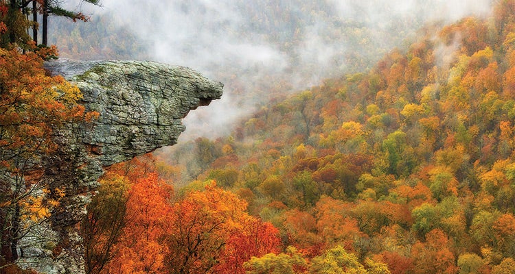
'See Hawksbill Crag on a 3-mile out-and-back from the Whitaker Point trailhead south of Ponca. photos: Tim Ernst'
The Insider
Wildlife photographer Tim Ernst lives right off the Buffalo River’s headwaters and literally wrote the book on it: Buffalo River Hiking Trails ($20; timernst.com).
Know Your Options
When people refer to the Buffalo River Trail, they’re usually talking about the original 36.3-mile path (now known as the Western Section) that follows its namesake from Boxley to Pruitt. But you should target one of the other two lesser-known sections (that aren’t linked to the original yet) for solitude: The 15-mile Eastern Section starts about 20 miles east of the Western Section in Woolum and ends at the AR 65 bridge, and the 11-mile South Maumee Section starts about 10 miles east of the Eastern Section at South Maumee Road and ends at the AR 14 bridge.
Hike-’n’-Float
The best Buffalo River experience needs a bluff-top campsite and an easy paddle. Get both when you hike the Eastern Section east to west: Camp on Whisnant Hollow Bluff (perfect for catching the sunset) midway through. In Woolum, instead of hiking back, paddle downriver. Rent a canoe from Buffalo River Outfitters ($50/day; buffaloriveroutfitters.com), and they’ll drop it off and pick it up ($7).

ADVERTISEMENT
Chase Waterfalls
The 5-mile out-and-back to the 209-foot Hemmed-In Hollow Falls is worth your time, but it’s popular. For a quieter waterfall hike, do the 2-mile out-and-back to the twin Maumee Falls from County Road 52. “Or, pick any creek, follow it, and chances are there will be a cascade along the way,” Ernst says.
Meet the Locals
Thanks to an introduction program in the 1980s, some 400 Rocky Mountain elk call the headwaters home. Take the BRT from Ponca (where elk wade in the river) 2.5 miles to Steel Creek (where they sometimes gather).
Blink Twice
Foliage usually peaks the last two weeks of October. In addition to the red-and-orange hardwood display, see the understory sassafras, sumacs, and black gums) turn intense yellow, scarlet, and even purple.
ADVERTISEMENT
Trip Planner
Season Year-round, but fall through spring is best. Permit None Contact nps.gov/buff