Updated December 4, 2024 12:36AM
Secret Hikes: Guadalupe Mountains National Park
Climb from sublime desert to pine forests and peaks with 100-mile views.
'Valley cacti in bloom. (Mark W. Lisk)'
| Secret Hikes: National Parks Home |
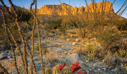
Packing for a hike in this west Texas park is a challenge: Do you prepare for the open desert, rugged canyons, or high mountains? All three, actually, which is why some aficionados call this the best-kept secret in the national park system. Stay overnight in the backcountry, and you’ve found the secret inside the secret.
The park’s remote location and lack of water (it’s strictly BYO for backpackers) mean you’ll have the place virtually to yourself. Make the weekend traverse from McKittrick Canyon trailhead to Pine Springs, and you’ll sample all of Guadalupe Mountains National Park’s diversity: yucca- and agave-dotted desert; breezy limestone and sandstone ridges overlooking sheer-sided, multifingered canyons; and cool-air mountaintops with Texas-size vistas. It’s 19.1 miles via the most-direct trails, but choose a slightly more circuitous, 24.1-mile route—linking Blue Ridge, Bush Mountain, Bowl, and Bear Canyon Trails—for the best of everything. Camp at the McKittrick Ridge campsite the first night—it has sunset views of the range’s highest peaks.
On day two, traverse narrow ridges and forests of ponderosa pine and Douglas fir to reach the Pine Top campsite. Pack binoculars and scope for some of the park’s 300 bird species. Posthike, allow time for two must-do day trips: Climb Guadalupe Peak, the highest in Texas at 8,749 feet, and explore Devil’s Hall, a nearby slot canyon with steps carved into the rock.
Magic Moment You pitch your tent at the end of day one’s 2,500-foot climb over dozens of switchbacks: The remote site on McKittrick Ridge–empty and view-packed–will rank as one of your all-time favorites.
Local Knowledge Elk in Texas? Believe it. Hike the Bowl Trail from the Pine Top campsite at dawn or dusk, and pass through Douglas fir where elk hang out in September and October.
Do It Start at McKittrick Canyon trailhead (3.5 miles off US 62/180, 108 miles east of El Paso). End at Pine Springs trailhead, .25-mile off US 62/180 (seven miles southwest on 62/180).
Map Trails Illustrated Guadalupe Mountains #203 ($12; natgeomaps.com)
Contact (915) 828-3251; nps.gov/gumo