Published June 24, 2010 07:11PM
Secret Hikes: Grand Teton National Park
Rise above the crowds and earn solo views of elk, wildflowers, and summit sunsets.
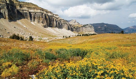
'Alaska Basin, off the Teton Crest Trail. (Ethan Welty)'
| Secret Hikes: National Parks Home |
Consider this 30.5-mile loop a lesson in investments. While hikers focused on short-term gains jostle for permits to the more accessible (and, yes, gorgeous) loop of Cascade and Paintbrush Canyons, venture a little more sweat equity and embark from Death Canyon trailhead instead. The payoffs are astounding: You’ll score solitude and million-dollar views of the Teton spires—and you won’t have to motor from camping zone to camping zone to nab the best sites. The route links Open Canyon, Mt. Hunt Divide, Granite Canyon, Alaska Basin, and Static Peak Divide to delve deep into the big, open country of the wildlife-packed southern Tetons, a less-visited area of rugged canyons, wildflower-strewn plateaus, endless mountain vistas—and empty campsites.
From the trailhead (ignore initial company; other hikers soon vanish), go 1.6 miles to a fork and turn left to arc around Phelps Lake toward Open Canyon (keep an eye out for moose at the lake’s edge). Then cruise 11.4 miles on the Open Canyon and Teton Crest Trails, past the distinctive spire of 10,131-foot Spearhead Peak, to camp atop Death Canyon Shelf at 9,500 feet. Day two is packed with scenery, and it jumps from great to greater around mile five, with a 30-minute, round-trip detour up 11,303-foot Static Peak to its 360-degree panorama. Camp creek side in Death Canyon; then close the loop with an easy four miles back to the trailhead.
ADVERTISEMENT
›› Magic Moment When you turn off your headlamp to go to sleep, on Death Canyon Shelf, you hear an elk bugle startlingly close to your tent. A close second: waking at dawn to stroll to the canyon rim, where you sip coffee and glass the valley 1,000 feet below for moose.
›› Local knowledge Comfortable with off-trail navigation and scrambling? Access a long-abandoned route from 10,680-foot Avalanche Divide through wild and craggy Avalanche Canyon, reaching a junction with the Alaska Basin Trail. The three-mile trail is faintly visible from the west side of Veiled Peak.
›› Do It Take Moose-Wilson Road (near the Moose Visitor Center) three miles to the signed right turn for Death Canyon trailhead; continue 1.5 miles. Map Trails Illustrated Grand Teton #202 ($12; natgeomaps.com) Contact (307) 739-3300; nps.gov/grte
[Best-Kept Secret]
Climbing
“Get a taste of mountaineering on the southwest couloir of Middle Teton,” says our map correspondent. “This class 3 route is never crowded and has the best view of the Grand Teton in the whole park.” Camp in Garnet Canyon, then continue west up the gully, while other climbers march like ants to the Grand.