Published January 11, 2010 06:52PM
Readers' Choice Northeast Hikes: Panther Gorge and Mt. Marcy, Adirondack Park, NY
Bag New York's high point and two other big peaks.
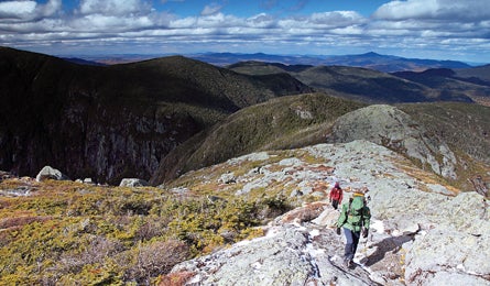
'Panther Gorge & Mt. Marcy Adirondack Park, NY (Tim Seaver)'
Yes, 5,344-foot Mt. Marcy attracts a crowd. No, you don’t have to join it. Most hikers follow a series of trails from the Adirondack Loj to the east. But heed our team’s advice: Head for Marcy’s summit via the Elk Lake Trail and you’ll find guaranteed solitude—and a perfect long weekend—on a 30.6-mile, three-day backpack that tags Marcy and two more 4,000-footers. “It’s pure wilderness,” promises Tim Dubois. “It’s everything you like about the raw, wild character of the Adirondacks rolled into one trip.”
Day one Set out on the Elk Lake Trail (marked with blue discs), which slips through private land for the first 6.5 miles (no camping permitted). At mile 5.5, reach an open bog called Marcy Swamp, with views north to the mountain. In another 3.2 miles, pass an open area in an otherwise dense beech forest where Hurricane Floyd flattened the trees in 1999. Just after, enter Panther Gorge and gain 1,200 feet in a little over three miles before reaching Panther Gorge lean-to and its nearby tent sites. Set up a basecamp here.
Day two Load a daypack and get going at sunrise for a wicked-beautiful 7.2-mile day. Continue north on the Elk Lake Trail .3 mile and turn right at an easy-to-spot (but unsigned) junction to ascend Bartlett Ridge; climb 500 feet in a half-mile to a bench and another junction. Turn left to summit 4,960-foot Haystack Mountain, reaching timberline in .4 mile. Descend to the north via an unnamed trail (follow cairns and yellow marks) for .6 mile to the blue-blazed State Range Trail. Take this a half-mile to a left onto the red-blazed Phelps Trail, which leads .7 mile to the Van Hoevenberg Trail. Turn left and ascend above treeline on lichen-covered rocks, reaching Mt. Marcy’s summit in .6 mile. Descend via the .8-mile Calamity Brook Trail to the Four Corners. Feeling spry? Climb .5 mile south to summit 4,926-foot Mt. Skylight. Burnt? Take the Elk Lake Trail left to return to camp.
Day three Reverse day one’s route to reach your car.
ADVERTISEMENT
PLAN IT
Driving From Albany, take I-87 for 89 miles north to Blue Ridge Rd. Turn left and go four miles to a sign for Elk Lake Lodge. Turn right and go 5.2 miles to trailhead parking.
GearBear canisters required (rentals available through the Adirondack Mountain Club).
Map and guide Adirondack Trails: High Peaks Region ($20, adk.org, comes with maps)
Contact (518) 668-4447, adk.org