Published October 27, 2011 12:06PM
These Are Our Resident Midwesterner's 3 Favorite Trails In The Region
This region's top mapper has notched 20 bag nights and 200 trail miles in 9 states this year alone. Here are three of his favorite routes.
(Photo: © Owen Weber (www.owenweberlive.com) via Getty Images)
Dayhikes
Mounds State Recreation Area, Indiana
The land that is now Ohio and Indiana was once home to the thriving villages of the Miami, an extravagantly tattooed tribe that farmed this region’s fertile soils up until the 1830s. “The grassy ceremonial mounds in southeast Indiana are a neat window into their past,” says local expert Stuart Peck. “Plus, this route is close to hikers in three states.” Trek where the Miami gathered by following lollipop-shape Glidewell Trail’s 4.5 rolling miles. Follow the tree-lined path along the eastern shore of 5,260-acre Brookville Lake (a local-favorite fishing hole for walleye, crappie, and bass) to arrive at sweeping views of the usually calm waters reflecting the broad Midwestern sky. Find evidence of the once-prominent Native American settlement at mile two, where you’ll pass a smooth 2,000-year-old mound, likely a temple. This region has mild terrain and many creek crossings. Opt for a light, quick-drying boot. Contact in.gov/dnr/parklake/2961.htm
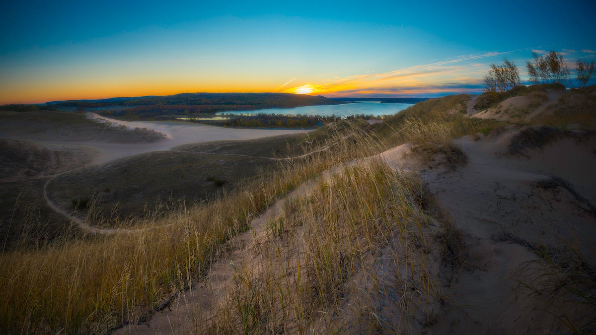
Weekender
Sleeping Bear Dunes National Lakeshore, Michigan
With waves lapping onto white-sand beaches, Manitou Island, an hour from the mainland, feels a world away. “And it’s downright tropical in high summer,” raves Peck. His favorite hike: The North Loop, a 17.3-mile circuit with fire-tower-like views of Lake Michigan and shady stands of white pine and cedar. At mile three, sidehike to the island’s highpoint (1,001 feet). At mile 5, pass the apple orchards and abandoned homes of an 1800s farm town. Continue south to 300-foot shoreline bluffs and, on a clear day, spot the mainland’s Sleeping Bear Dunes. Camp in the Village Campground (in sight of the shore) and dayhike—or get a wilderness permit and camp anywhere on the island (at least 300 feet from shore). Contact nps.gov/slbe
Multiday
Dakota Prairie National Grasslands, North Dakota
“We Midwestern backpackers spend a lot of time looking for routes that rise above the trees and deliver a view,” says Peck. “That’s why the Maah Daah Hey Trail is special. The climbs are short and easy, and the views are nonstop.” This 97-mile point-to-point has sprawling prairie scenes interspersed with the starkly beautiful, striped-rock outcroppings of the badlands. From Sully Creek State Park, just south of Medora, hike north through native mixed grass, watching for bighorn sheep on the buttes. Camp in four established sites (18 miles apart) with vault toilets and potable water, or plan to haul water (or cache at campsites near road crossings; see contact). More highlights: Glimpse the northern lights (early winter), bison, and feral horses. Contact mdhta.com