Published June 17, 2008 07:30PM
Quick Fix: South Dakota's Black Hills
Learn where to bag peaks, visit hidden cold water lakes, and trek through the eroded wonder of Badlands National Park in our Black Hills primer.
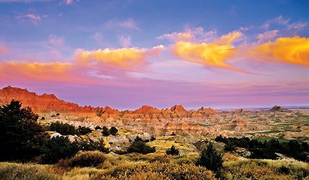
'So bad it's good: Cedar Pass Sunsets.'
3 HOURS
Earn big rewards for little work
The Black Hills rise above the prairie, concealing cold-water lakes, aspen stands, and elk herds. Get a quick taste on this 5.5-mile lollypop route built in 1991. From the trailhead, just 20 miles northeast of Sundance, Wyoming, head up the Cook Lake Trail, winding through saplings and waist-high grasses. After one mile, link to the Cliff Swallow Trail, turning left to begin a steady ascent to a sloping ridgeline with sweeping views of sparkling Cook Lake and open terrain patched with ponderosa pine and burr oak. From here, descend to Beaver Creek, where you’ll likely see the buck-toothed builders at work and white-tails drinking at dawn and dusk. Turn right onto the Cook Lake Trail to return.
5 HOURS
Summit a locals’ favorite
Crow Peak, the 5,760-foot backdrop to the adventure town of Spearfish, is the climb of choice for townies needing a fix. To bag it, do this 7.4-mile trek: Head out on the Crow Peak Trail (6.5 miles southwest of town) and climb through the cool shade of pines and crumbling red sandstone. At mile 1.8, a half-mile spur trail leads to Beaver Ridge–and great wide-angle views into northern South Dakota’s sprawling yellow grasslands. Then switchback beyond treeline to 360-degree vistas of Bear Butte, Spearfish Valley, and Montana’s very big sky. Pack raingear and descend before 1 p.m. to avoid the thunderheads that regularly build here during summer months.
ADVERTISEMENT
10 HOURS
Blaze your own path
The terrain on this cross-country exploration of Badlands National Park looks as if the earth exploded and froze in place, rippled and wrinkled, gathering eons of dust and sand. There is no trail, just delicate eroding spires, a few hundred bison, and endless hiking possibilities. Start from the dirt turnout 50 yards down Sage Creek Rim Road after turning off SD 240, 8.2 miles from Wall. Wind your way down Ranger’s Pass, a half-mile maze of tight slots and dead ends, stacking cairns to retrace your steps. Once in Sage Creek Basin, explore the countless buttes and alien landscapes. Locals say the sunset is impressive from inside the basin; if you linger, be sure to pack a headlamp for the way out.