Published May 22, 2008 02:17PM
Quick Fix: Great Smoky Mountains NP
Check out the steepest trail, the best swimming hole, and the wildest vista in America's most popular national park.
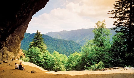
'A view of the Sugarland Mountains from ALum Cave, Photo by Steven McBride'
3 Hours
Climb the park’s steepest trail
Been working those quads? Test their climbing power on the Mount Sterling Trail stairmaster. You’ll gain 2,000 feet on the 2.3-mile ascent to the trail’s 5,842-foot namesake summit. Grab a map ($1) at the Big Creek Ranger Station in Cove Creek, then go 21 miles west on I-40 to Mount Sterling Road. Head south to the trailhead at Mount Sterling Gap and hike west along the MST, a wide path that switchbacks through old-growth pine. Hang a right atop the ridge and head another half-mile to a fire tower and one of the few (and the best) unobstructed 360-degree views in the park. Give your legs a rest while you scan 52 miles from the Pigeon River Gorge to the Unaka Mountains.
6 hours
Hike to countless swimming holes
Pack your swim shorts for this leisurely 10-mile out-and-back along the banks of placid Big Creek. Better yet, just wear them–there are as many swimming holes and falls here as there are bends in the river. Park at the Big Creek Trailhead (two miles south of Waterville) before 9 a.m. to snag one of the 30 parking spots (they go fast). Hike southwest from the parking lot and wind through dense stands of oak, maple, and beech. At mile 1.5, you’ll find the first of many pools just 10 feet off the trail. It’s a Jacuzzi-like bath at the base of a double falls called Midnight Hole. You’ll want to linger, but more awaits: Meander four miles upstream to braided Mouse Creek Falls, and another cool pool.
ADVERTISEMENT
10 hours
Ditch crowds with an early start
Fact: Trails in GSMNP are among the busiest in the United States, meaning solitude comes at a price. The answer? Start this hike before 8 a.m. “You’ll beat the traffic by an hour,” says backcountry ranger George Minnigh. Leave a car at Alum Cave Trail (10 miles from Gatlinburg) and drive 4.6 miles to Newfound Gap. From there, hike north along the Appalachian Trail for 2.7 miles, turning left onto the Boulevard Trail. Begin a roller coaster of short climbs and descents through spruce forests and chalkboard-grey anakeesta shale rock formations. You’ll top out after 8.1 miles on Mt. Le Conte’s 6,593-foot summit. Drink in rolling valley views and head 4.9 miles down the Alum Cave Trail, passing late-comers on the way.