Updated December 3, 2024 09:24PM
Quick Fix: Death Valley National Park
Badlands, peaks, wildflowers: Catch the best of the California desert with this trio of hikes.
'Photo by Chuck Haney'
3 Hours | 5 Hours | 8 Hours
3 Hours
Explore Silent Sands
Sometimes it’s easy to avoid the crowds: Just head the other direction. In the sand dune country around Mesquite Flat, north of Stovepipe Wells, most hikers march like ants to the area’s high point, an unnamed 100-foot-high dune. Instead of joining the parade, head cross-country from CA 190 to the dune field’s empty east or west ends, tucked into the base of the valley wall. Here, the only tracks disturbing the wind-sculpted sand belong to kangaroo rats, kit foxes, and horned rattlers. Mornings and evenings (when the wind dies down) are the best times to chart your own easy course in the trailless sand; in summer, avoid the dunes’ sole-melting heat (it can be 100°F at 8 a.m.) by striking out during a full moon.
3 Hours | 5 Hours | 8 Hours
3 Hours | 5 Hours | 8 Hours
5 Hours
Hike the Valley’s Badlands
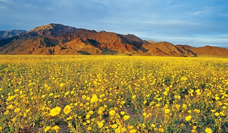
Desert wildflowers come and go in early spring (call the hotline below to catch them), but badlands are forever. Actually, badlands is an insult to Death Valley’s colorful, wildly shaped landscape of sand, clay, and rock. The five-mile Golden Canyon/Gower Gulch Loop (park two miles south of Furnace Creek) winds through rippled sandstone walls formed 10 million years ago, when shallow lakes covered the region. Take the half-mile detour to Red Cathedral’s crimson cliffs, then resume the loop to the base of Manly Beacon, a rocky perch in the center of dusky folds undulating out in every direction. Return via Gower Gulch, slicing through the Artist’s Palette formation of pink, red, green, and blue.
ADVERTISEMENT
3 Hours | 5 Hours | 8 Hours
3 Hours | 5 Hours | 8 Hours
8 Hours
Escape to High, Cool Peaks
In midsummer, when the valley floor sizzles at 120°F, Death Valley’s summits average 40 degrees cooler. Scale the Panamint Mountains’ 9,064-foot Wildrose Peak, where the view encompasses the Lower 48’s highest and lowest points (14,505-foot Mt. Whitney and minus-282-foot Badwater Basin, respectively). The 8.4-mile round-trip begins at Wildrose Campground. The first mile traces an old roadbed through piñon-juniper forest, then scales an open ridgeline for 2.2 miles. The 2,200-foot climb tops out on a rocky grandstand overlooking immense plains framed by spiky mountain ranges. Hike up high in early spring, and you’ll get a bird’s-eye view of hundreds of square miles of wildflowers.
3 Hours | 5 Hours | 8 Hours