Updated December 3, 2024 08:28PM
Peak: Mt. Whitney, CA
Check out the Mountaineer's Route of Mt. Whitney if you're looking for a challenge.
'may 2010 zones whitney 200x170'

There’s the easy way to summit the Lower 48’s highest peak, then there’s the Mountaineer’s Route. After five miles of class 3 climbing stand on top at 14,505 feet, with views of lake-filled cirques and ripsaw ridgelines. Off-season: Bring ice climbing gear and a partner.
INFO Self-register for permits (free) from December to April. For May to November, enter the lottery before February 15; the Forest Service reserves 40 percent of permits for walk-ins. (760) 873-2400; fs.fed.us/r5/inyo. Trip data: backpacker.com/hikes/483527
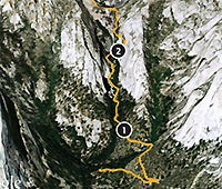
1. Whitney Portal
0388599E 4049772N; mile .8
Veer right off main trail and follow cairns.
2. The Ledges
0387904E 4049662N; mile 1.3
Traverse features left to right. If icy, wear crampons or turn back.
3. Iceberg Lake
0385057E 4049118N; mile 3.8
Camp here (elevation: 12,730 feet ). Get an alpine start.
4. Notch on North Ridge
0384251E 4049004N; mile 4.5
Go south on ledges and gully (direct), or west on narrow trail.
5. Summit
0384407E 4048905N; mile 5
Ridgewalk north to summit. Storm coming? Get off peak fast.

*Google Earth Providers: Google, Data SIO, NOAA, U.S. Navy, NGA, GEBCO, Image DigitalGlobe, Image AMBAG, Image U.S. Geological Survey, Image USDA Farm SErvice Agency, CNES/SPOT Image.
Go Big
See more peak hikes