Published May 24, 2010 03:24PM
Peak: Mt. Washington, NH
If you don't mind the potential of extreme weather and wind, Mt. Washington is your hike.
'may 2010 zones mt washington 200x170'

Savage weather and vicious wind (strongest gust: 231 mph) can turn a dayhike here into a hypothermic death march ; winter whiteouts can make cairn-hopping impossible. But don’t be daunted—just come prepared. Know how to follow the route if conditions deteriorate, and don’t skimp on layers and raingear. You’ll switchback up 1,500 feet and scramble over boulder gardens on this 3.8-mile route. If the road is open, you’ll see tourists on top, but rest easy: You can’t overestimate the satisfaction of climbing what others drive. INFO No permits. (603) 356-2137; mountwashington.org. Trip data: backpacker.com/hikes/59657
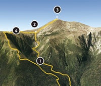
1. Hermit Lake
0317495E 4903294N; mile 2.2
Check weather report at cabin before ascending above treeline.
2. Tuckerman Ravine
0316220E 4903693N; mile 3.2
Follow cairns north. Snowdrifts covering them?
3. Mt. Washington
0316172E 4904473N; mile 3.8
Cross the parking area to gain the true summit.
4. Davis Path Trail
0316163E 4903122N; mile 4.7
Stay left/southeast at junction. Take Boott Spur Trail in .6 mile.
*Google Earth Providers: Google, Data SIO, NOAA, U.S. Navy, NGA, GEBCO, Image DigitalGlobe, Image AMBAG, Image U.S. Geological Survey, Image USDA Farm SErvice Agency, CNES/SPOT Image.

Go Big
See more peak hikes