Published May 23, 2008 11:32AM
Paddle and Hike Voyageurs National Park
With a thousand islands and countless passages, this little-visited treasure is a watery maze. Here's the way in–and out.
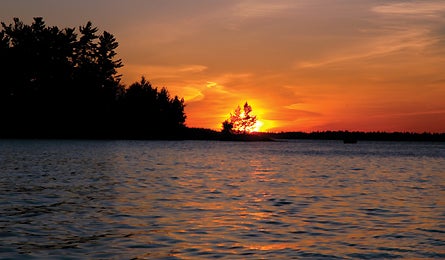
'Kabetogama Lake, Ryan Rodgers'
The first visitors to what would become Voyageurs National Park were fur-trading French-Canadian explorers–aka voyageurs–piloting 26-foot birch-bark canoes between Montreal and the uncharted West. Unless you have wings, water is still the only way into this 220,000-acre wilderness five hours north of Minneapolis. With more than 1,000 forested islands, interconnected waterways, and four giant lakes ringed by 600 miles of rocky shoreline, you’d need several lifetimes to pack in all the voyages here.
Scratch the surface with this five-day, 65-mile sampler that begins at Kabetogama Lake. From the Ash River Visitor Center, steer your canoe or kayak a quarter-mile north to 75,000-acre Kabetogama Peninsula, home of the 9.5-mile Cruiser Lake Trail. Stow your boat in the dense pines and hike the full 9.5 miles to a cliff-side campsite at Anderson Bay Overlook, 80 feet above Rainy Lake. In the morning, hike back and paddle to Peterson Point, an idyllic craggy site you’ll reach by dinner. Day three is an easy five-mile paddle east past squiggly inlets to tiny Hamilton Island, which features a single campsite tucked among soaring pines.
In the morning, push 14 miles to Beaver Bay, a 100-rod portage (one rod = 16.5 feet) to Fields Channel and your pick of nearly 30 campsites scattered across the park’s eastern half.
ADVERTISEMENT
Take your time rounding back to Ash River, stopping to visit the Gull Island Rookery on Namakan Lake. The island is a birthing site for thousands of gulls and great blue herons, whose nests are so ephemeral-looking they appear to hover–rather than rest–in the trees’ crowns. (Plan your trip in early June to see hatchlings through your binoculars.) From Gull Island, paddle four hours to Williams Island, dotted with two more remote campsites. Take your pick from a south- or west-facing site, and beach your boat for one more night before returning to solid ground just a morning paddle away.
Map
Fisher Map’s V-3, covering eastern VNP ($8; fishermaps.com)
Outfitter
Boreal Explorations in Rainy Lake rents boats and gear (and guides trips). (218) 286-1342; borealexplorations.com
Permits
No permits are required to enter the park, and campsites are first-come, first-served. Check conditions at (218) 283-6600; nps.gov/voya