Updated December 3, 2024 03:57PM
One Night Wonders: Peak Baggers, Blanca Peak and Ellingwood Point
Tag two tough fourteeners.
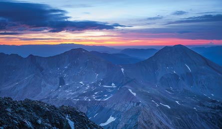
'Blanca Peak and Ellingwood Point, Sangre De Cristos, CO (Glenn Randall)'
Blanca Peak and Ellingwood Point
Sangre de Cristos, CO
Compared to Colorado’s easier-access Fourteeners, Blanca Peak’s 14,345-foot summit plays hard to get with a 7.5-mile approach and 6,350 feet of elevation gain. But the effort gets you extra solitude and a twofer deal, since you can tag 14,042-foot Ellingwood on the same effort. Most hikers overnight in the Como Lake basin to time their summit bids for the morning hours (when lightning storms are less likely). From the trailhead (1.5 to 3 miles off CO 150, depending on your car), the Blanca Peak Trail follows a steep, rocky jeep road—so rough that most people walk it—about 5 miles to Como Lake. For a quieter night, continue .5 mile farther toward the Blue Lakes and pitch your tent at treeline on the broad, flat bench between Como and Blue, 2 miles from Blanca’s top. Keep your eyes peeled: This is bighorn territory. Rise before sunrise to hike on-trail past Crater Lake and climb east out of the cirque, following rock cairns through the talus field. At the saddle between Blanca and Ellington, panoramas unfold in all directions: To the west, the 5,000-acre Blanca Wetlands shimmer in the early light; to the east, 14,042-foot Mt. Lindsey and its attendant Thirteeners catch dawn’s alpenglow. Hike south, following Blanca’s knife-edge ridge to Colorado’s fourth-highest summit, then backtrack to the saddle and contour north to tag Ellingwood. Option: Stay another night to add 14,037-foot Little Bear Peak to your collection (class 4 scrambling required). Trailhead 115 miles southwest of Pueblo; 37.550591, -105.559097Best season High-meadow wildflowers peak in July. Permit Free trailhead registration required. Contact (719) 852-5941; fs.usda.gov/riograndeTrip data backpacker.com/hikes/30993