Updated January 4, 2025 10:53AM
Not Exactly Roughing It on Idaho's Salmon River Trail
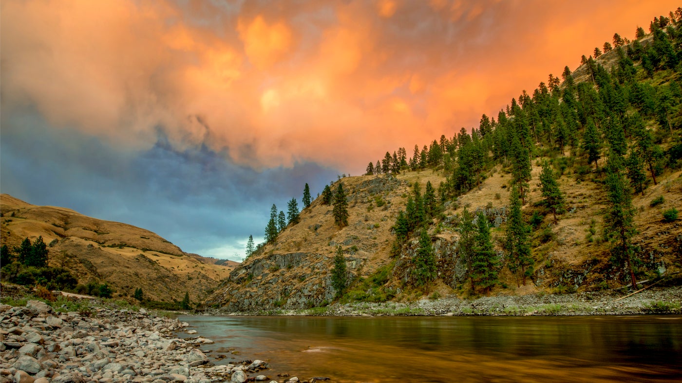
The Middle Fork of the Salmon River Trail is a 100-mile-long backpacker's dream that comes complete with muscle-soothing waters and the occasional glass of wine with your four-course dinner.
(Photo: alacatr via Getty Images)
It was my last night on the Middle Fork of the Salmon River Trail, a 100-miler along Idaho’s Salmon River. I was enjoying the solitude on an exquisite jewel of a white-sand beach. My heart was aching that I didn’t schedule a few more days to sit by the river’s edge and listen to what it had to say.
Suddenly, I heard a splash. I swiveled my head in its direction and spied a tiny, blue catamaran angling toward my beach. The oarsman noticed me just as he touched shore. “Oh. Sorry. I didn’t see you.”
“No problem,” I told him, half meaning it.
“Say, I wonder if you’d mind company tonight?”
“Uhhh, well, I guess…”
“Great! My hunting buddies are a mile up the river. I told them that if anyone was on this stretch of beach I’d just hike back up and we’d make camp at their raft. Are you sure you don’t mind? It’s no problem if you do.”
ADVERTISEMENT
I hesitated long enough to let my disappointment show, then assured him, faintly, it would be fine. He reached into his raft, pulled out a 12-gauge shotgun, and aimed it skyward. Blam, blam. I nearly jumped out of my skin as his prearranged signal reverberated among the canyon walls and echoed between my ears. This evening was taking on a life of its own. Ten minutes later, when the night had grown so dark that I could barely see halfway across the river, a great homemade spectacle of a raft right out of the movie Waterworld swept around the bend and glided to shore. Two men jumped off carrying cases of beer.
Oh well, if you can’t beat ’em, join ’em. I cracked open a cold one.
The Middle Fork of the Salmon River Trail

I didn’t really know what to expect hiking this 100-mile trail, but I found it all—and more. The Middle Fork of the Salmon River in the Frank Church River of No Return Wilderness (MFSRFCRNRW, for short, sort of) is a collection of paradoxes. It is superbly wild yet smattered with small ranches. It’s as fine a trail as I’ve traveled but utterly devoid of hikers. I enjoyed days of undisturbed privacy but nights of unanticipated-and not entirely unwelcome-socializing. The Salmon River Trail itself lies at the heart of the largest designated wilderness area in the Lower 48, but it’s easily accessed by air service, which I took advantage of at the hike’s end.
A Brief History
Airplanes and ranches in a wilderness? Well, sometimes to preserve a canyon you have to bend like a river, a lesson well known to legendary Idaho Senator Frank Church. Besides his renown in foreign policy, Church was revered and reviled as the floor manager for the original 1964 Wilderness Act and author of the Wild and Scenic Rivers Act of 1968. He was also the point man in later efforts to designate four Idaho wilderness areas, including the granddaddy of them all, the one that now bears his name, the Frank Church River of No Return Wilderness.
To push this gigantic 2.4-million-acre wilderness through Congress, Church and his allies had to incorporate a few things you wouldn’t expect in a primitive area. These included 24 gravel airstrips used by hunters, fishermen, ranchers, and forest-service workers since the 1920s. They also grandfathered in a few historic ranches that continue to operate on private land within the reserve.
ADVERTISEMENT
The River of No Return Wilderness Bill was finally passed in 1979, one year after President Jimmy Carter rafted the Salmon River Trail’s Middle Fork with Interior Secretary Cecil Andrus. In 1984, as cancer laid Church on his deathbed, Congress renamed the wilderness in his honor. About the victory he’d wrangled against stiff opposition, Church said, “The winners are the people of Idaho, who will enjoy the finest wilderness in the West, the crown jewel of the National Wilderness System.”
Hot Springs Along the Salmon River Trail
High among the spoils of this triumph is a collection of the finest hot springs this side of Hades. This fact didn’t mean much to me when I initially planned my hike, but that was before I met Leo Hennessy. Leo is an avowed hot-springs fanatic. As the non-motorized trails administrator for the Idaho Department of Parks and Recreation, he felt the professional need, nay, the duty, to christen my journey properly by accompanying me to one of his favorite soaks.
Unnamed Favorite Hot Springs
Three miles of trail and two thigh-deep crossings of Bear Valley Creek brought us to a rivulet that steamed as it dropped from pool to pool. There, just before the tiny stream’s warmth was lost to the frigid creek, we lay naked in its soothing waters, watching a brilliant Milky Way burn through the blackening sky.
ADVERTISEMENT
“You know,” said Leo, while steeping in Earth’s exquisite brew, “if you walk just right you can probably repeat this experience most every night down the canyon.”
Cooling off between dips, we searched the map for tiny blue circles indicating hot springs. There it was. Tomorrow night I’d rest in the blue circle labeled Sheepeater. Never mind the roughly 28 trail miles separating here and there.
In the morning, we soaked again, then Leo accompanied me to where Bear Valley Creek and Marsh Creek converge to form the Middle Fork of the Salmon River Trail. Leo had to leave to return to “the office”—in his case, to construct yurts for winter campers high in the mountains above Boise. “Poor me,” he sighed at the thought of heading back to the daily grind.
ADVERTISEMENT
“Build ’em snug,” I teased, “because I’ll be back with a pair of skis.” Then I spun around and strode the splendid trail. At 6,500 feet the hillsides were thick with Douglas and alpine fir, the air sweet with duff and moisture. Soon the woods opened to reveal autumn-tinged aspen groves dotting the rocky hillsides like gold flecks in a miner’s pan.
Sheepeater Hot Springs
I fairly floated down the trail that day, past four horseback riders with handlebar mustaches and cowboy chaps, past two footsore hunters humping bloody sacks of elk meat out of their deep-hills camp, past abandoned log cabins hinting of mining dreams gone sour, and down, down, down the otherwise empty Salmon River Trail. Wearily, I reached Sheepeater Hot Springs and its riverside campsites.
There I stood barefoot in the river, letting its numbing waters cool my flaming knees. A search through warm mudflats led me to a 103°F pool into which I slowly eased with a reclining “ahhh”—the ideal closing to a high-paced day. I love motion but my body wasn’t in tune with the kind of pace I’d kept that day, and I was glad for the soothing heat.

The morning sun was still well below the skyline when I struck off the next day. Gentle valley walls rose some 5,000 forested feet to ridgelines, and the cool air of the shadowy canyon made for perfect hiking weather. A few miles downstream an armada paddled by. Three kayaks and a support raft looked uncannily like PT boats surrounding an aircraft carrier.
ADVERTISEMENT
A few miles farther still, I met the paddlers at the Indian Creek Forest Service guard station, where boaters must check in. Backpackers, being a relatively rare breed hereabouts, are exempt from most such regulations. As it turned out, we’d shared camp the night before. Because Sheepeater is such a sprawling site, we’d seen nothing of each other but our distant tents.
Sunflower Hot Springs
In another couple of miles one of the kayakers paddled toward me as I cruised down the riverside trailway.
“Hey!” he yelled up, “Care to join us at camp tonight?”
I replied that I wasn’t sure how far I wanted to hike that day. When I’m in motion I sometimes just like to let the end of the day tell me when to stop rather than fixing on a particular destination.
“It’s called Sunflower Hot Springs, on the other side of the river. I’ll give you a ride across if you want.”
ADVERTISEMENT
“Thanks,” I said, “I’ll signal if I feel like stopping.” I really wasn’t in the mood for the company of strangers. Observing a few boaters as I hiked didn’t bother me—after all, the total count of humans I’d seen each day had been lower than I could expect on almost any trail within striking distance of a major city. Better yet, I’d seen no signs at all of fellow backpackers.
That afternoon, as I rounded a bend, I saw the rafters’ tents beside a steaming waterfall. I was standing in the trail under the grip of temptation when the kayaker spotted me and waved. I waved back, and moments later I found myself sitting in a cliff-top pool of hot water with a cup of wine in my hand.
My new friends were two couples in their 30s from Salt Lake City and another in their 60s from Cody, Wyoming. We were sharing wine when our chef exclaimed, “We’ve forgotten the beans for the burritos!”
How often can a backpacker come to the culinary rescue of a rafting party? My meal happened to be freeze-dried beans, Santa Fe style.
“Let’s see,” I ruminated out loud. “I’ll share my beans if you share your fried tortillas, veggies, tomatoes, chips, guacamole, and wine. Deal?”
ADVERTISEMENT
Hospital Flat Hot Springs
The next morning, refreshed and espresso-filled, I struck off with a new bounce in my step. The changing landscape played no small role in my sky-high spirits. Fir gave way to ponderosa pine, and pine in turn opened up to no trees at all except around springs and tributaries. Sages of various sorts bloomed bright yellow. To a forest-flush Oregonian like me, the metamorphosis into high-country desert was fascinating. My spirit felt free and unconfined as it roamed across the landscape faster and farther than even my rejuvenated legs could travel.
When I reached Hospital Flats Hot Springs, a rafter’s camp where my paddling friends and I had talked about sharing another evening, nobody was in sight. I waited, then waited some more, pacing restlessly. After an hour I realized that I just couldn’t wait any longer. I was falling in love with movement, with flowing down the trail like a piece of driftwood caught in the river’s current. Miles, and the more the better, were what I craved. Finally, I could take it no more and struck off until dusk caught up with me at a sandy beach.
ADVERTISEMENT
But what? No hot springs? How terribly uncivilized.
A Sandy Beach (no hot springs) Camp
At least I had the place to myself, or so I thought until I noticed a light in the trees just downriver. Curious, I wandered over and found a couple of tent cabins and a small log building with smoke trailing from the chimney. Two elk skins covered in salt lay stretched on the ground. Antlers clung to skulls balanced on a hitching post. I retreated to my sandy beach.
And so it happens that on my final night in the largest wilderness area in the Lower 48, I at last have camp entirely to myself. My mind replays the day’s events-the mountain sheep I witnessed prancing across stupefyingly sheer cliffs, the golden eagle that perched above me as I rested on the trail, the bear scat so full of seeds that I located the bush and ate the berries he’d left behind.
ADVERTISEMENT
Most of all, I reflect on the red petroglyphs I spotted on the walls of a riverside cave. Sheepeater Indians had once lived here, renowned for the bows and snowshoes they made from the horns of bighorn sheep. I guess this canyon always has been settled, if not by log-home builders, then by families in tepees. Still, whatever my century, I marvel at the emptiness of my beach.
What a glorious day of solitude. A perfect ending to a too-short trip. Even without hot springs, contentment seeps into my trail-weary muscles.
Then I hear a splash upstream.
“Oh. Sorry. I didn’t see you.”
No problem. I guess I’ve been expecting you.
ADVERTISEMENT
Expedition Planner: Middle Fork of the Salmon River Trail

Getting to the Salmon River Trail by Plane
Car shuttles make a one-way hike possible or you can add an exotic twist reminiscent of the Far North by flying in or out, as I did. Some pilots charge strictly by the hour while others have a fixed price for each landing strip. Beware that fatalities have occurred at every strip along the Middle Fork. Two of the most established flying services in the region are McCall Aviation and Arnold Aviation. I used McCall and lived to tell this tale.
Best Time to Go
September is postcard-perfect in the Middle Fork canyon. Early spring can be equally benign because the valley melts free of snow long before the surrounding high country. If access roads are blocked by snow, consider flying to Indian Creek and hiking downstream.
ADVERTISEMENT
Avoid riverside and creek-crossing travel from mid-May to the end of June. Hot weather triggers rapid snowmelt in the high country and swollen streams down low. Some sections of the Middle Fork trail can become submerged.
Mid-July through September provides good high-country hiking. July and early August at canyon bottom can be unbearably hot, unless you’re in a boat. By late August, low water and a new school year combine to drastically reduce boat traffic.
As September progresses into October you run an increasing chance of being trapped by snow anywhere in the wilderness.
Leave No Trace
There are specific rules when adventuring within the river corridor, a zone described as a quarter-mile on each side of the river’s center,
- Human feces must be carried out.
- Fire pans are required and charcoal must be carried out.
- No soap is allowed in the hot springs.
ADVERTISEMENT
Trails
The Frank Church River of No Return Wilderness is crisscrossed by an extensive trail network. The trail along the Middle Fork is in excellent condition the entire distance, but some remote trails in the wilderness are in disrepair from fallen trees. Unless you stick to the river’s edge, expect significant elevation gains and losses. Some high ridgelines allow superb off-trail hiking.
The Middle Fork of the Salmon River Trail is a great hike, but it’s just one of many. Why not try one of the following?
- Bighorn Crags: Spectacular granite pinnacles set among exquisite alpine lakes, by far the most famous and visited section of the Frank Church River of No Return Wilderness. It’s about 22 miles round-trip to Ship Island Lake, plus all the wandering you leave time for.
- Stoddard Lake/Twin Peak: This remote region offers plenty of challenging exploration. Cross the Salmon River at Stoddard Park Bridge, then climb steeply 5,400 feet out of America’s second-deepest canyon. Make a rugged week-long loop by combining the Stoddard Trail with cross-country hiking over Twin Peak.
- Sleeping Deer Mountain/Lower Loon Hot Springs: The gravel access road follows a spectacular ridgeline for 24 miles. The scenery includes little-visited alpine lakes, granite canyons, and subalpine meadows.
- Big Creek: This 70-mile down-and-back follows the historically rich Big Creek all the way to the bridge on the Middle Fork. Add a few miles to investigate the “monument,” a skinny 68-foot-high natural tower with a giant boulder on top. For a grand traverse of the wilderness with an epic car shuttle (or use a plane to return), continue up Waterfall Creek on the east side of the Middle Fork and hike out through the Bighorn Crags.