Published June 30, 2011 04:45PM
National Parks: Glacier
Rule #1 when planning a hike through this iconic park: Let your ambition match the scenery.
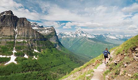
'The Highline Trail (Josh Miller)'

The Highline Trail (Josh Miller)

Mountain Goats Above Treeline (Pat & Chuck Blackley)

Along The Highline Trail (Bret Edge)

Dawn Mist Falls (Michael Wegryn)

Cosley Ridge (Michael Wegryn)

Descent From Swifcurrent Pass (Michael Wegryn)

Mt. Morgan And Oldman Lake (WildWestPhotos.com)

Pitamakan Pass (Michael Wegryn)
TRIP PLANNER | ASK A RANGER | WILD WONDERS | BEST WEEKEND
We hear soft, almost pained grunting, and it sounds close. But we can’t tell how close, because rain had driven us inside our floorless tent. The throaty whine grows nearer as we watch water slide down yellow walls. When you’re tentbound in Glacier National Park, every unexplained noise sounds like a grizzly, so my first instinct is to withdraw to the precise center of the shelter. Not my buddy Mike. He bursts out of his sleeping bag, grabs his camera, and rockets out the tent’s backside.
ADVERTISEMENT
He takes the four steps to our front-porch view of Kootenai Lake, a reedy, fir-fringed pond just a few miles from Canada. Then he takes four more, almost running toward the source of the sound: a very large moose, in rut. “As you can see,” he says aloud, narrating the video he’s taking, “I’m very close.” But still not close enough. He takes another few steps toward the bull, its school-bus-yellow, hammer-hard rack now only 20 yards away from Mike, who’s in the open at the water’s edge.
Then the moose pivots, sweeping one mammoth antler low enough to skim the grass, and heads directly for us. This is bad. Mike throws himself into reverse, pointing the camera backward as he runs. I see what the video chaotically records: the moose sauntering into the freezing lake. Bluff charge.
“That was awesome, bro!” Mike says, and laughs his crazy Woody Woodpecker laugh. “Did you see how close I got?”
ADVERTISEMENT
I did. Of course, moose are one of the animals I’d hoped to see on this epic, 56-mile northern loop in the Lower 48’s premier backpacking park, but seeing a bull’s individual chin hairs and sex-crazed eyes was not on my wish list. I’d been watching Mike go after close-ups like this for days, but this is the first time he brought one of his subjects back toward us. As much as I wanted to lecture Mike for flouting good sense and every rule in the humans-meet-wildlife playbook, I couldn’t help but appreciate the moment. It perfectly represented why I was here—with Mike—in the first place.
I’d long dreamed of hiking through Glacier’s storied terrain. For hikers like me, who cherish mega mountains and megafauna in equal proportions, the park is sacred ground. And I didn’t come here to keep the wild heart of the place at arm’s length. When I got a chance to spend a week backpacking in Glacier, I wanted a journey to match the legendary park: big, challenging, alive with the hourly possibility of coming face-to-fur with an animal that outweighed me by a quarter ton. I wanted long days filled with endless views of stegosaurus-spine ridges. And I wanted to do it in late September, long after the summer crowds were gone and (hopefully) shortly before the early-winter weather arrived.
And to make it all work, I needed a partner who would take the trip to the next level. I needed Mike. He’d proven himself on many such trips over the last decade. And where other companions have gotten doughy, Mike’s legs have toned to angular. Where others are thoughtful and cautious, Mike’s a walking, talking tornado of confidence, bad ideas, and that scary-silly laugh. I don’t always love his impulsiveness, but I’ll tolerate it for never-fail fitness and never-down morale.
ADVERTISEMENT
Our plan: Hike deep into the Waterton Valley backcountry from Many Glacier, camp alongside turquoise lakes that pool at the feet of steep-sided mountains, and return on the Highline Trail, a contour line below the Continental Divide.
When I picked up Mike in Missoula, he immediately filled the car with his 100-words-a-minute chatter. And that’s when I learned that ha-ha-what-a-character-crazy Mike had become clinically diagnosed Mike. On the two-hour drive to Glacier, he told me that he’d been diagnosed with bipolar II and a condition called hypomania. Doctors describe the latter as a persistent and pervasive euphoric, or “elevated,” state characterized by infinite energy, fierce competitiveness, and a gluttony for risk. Mike described it as “a 24-7 cocaine high!” and laughed his crazy laugh. Then he disclosed that he had gone on a self-regulated lithium wean a week earlier so he could hike faster.
In the moments after the Mike-moose encounter, a few thoughts race through my head: Rather than this hike’s key to safety and success, could Mike be a liability? Or, like many of us who seek out deep wilderness and the challenges it brings, could he find a unique kind of remedy here? And could bear spray deter a charging bull moose?
ADVERTISEMENT
A few hours after starting from Many Glacier, we pass through valleys draped with low, wispy-bottom clouds that hang down like the tentacles of a jellyfish. The morning sun paints the distant horizon orange as it climbs over the silhouetted Wynn and Allen Mountains to the southeast, but we’re still too low for the rays to reach us. The cloud curtain and dim light create an oddly complete quiet. Even the sound of 40-foot-tall, wrist-thick waterfalls plunging down all around us seems hushed.
Mike and I stop briefly along a small creek. He’s schooling me on the difference between the bipolar disorder most people know—the one characterized by listless lows and paint-your-whole-house-red highs—and his condition. He gets the highs more than the lows, and he doesn’t slip into psychosis, hallucinations, or paranoia.
“And there’s no God complex. You don’t think you’re Jesus,” he tells me. “But you do think you’re God’s gift to hiking or biking or running—or sex!” And he blasts forth that laugh again. The echo fills the space between Ptarmigan Wall and Crowfeet Mountain like a cackle of hyenas. Mike looks pleased. “When my mood’s elevated, I feel like I’m right about everything, like I can go and go and go and never need to stop!”
ADVERTISEMENT
And then, intentionally or not, he illustrates the symptom perfectly. We’re approaching 7,300-foot Ptarmigan Wall, where the misty clouds are thin enough to see through but thick enough to obscure distances. It’s like viewing the world through a veil, so it takes a few minutes to realize that the small brown dots in the distance are a half-dozen bighorn ewes. I realize that, anyway. Mike sees their stubby little horns and won’t be persuaded they’re not goats. I point out the “white pajamas” the sheep appear to wear when you see them from behind. I point out that mountain goats are white and shapeless with black horns. I point out that I work at a magazine that deals in this type of thing all the time. Mike will have none of it. He zooms off in pursuit of the “goats” while I continue up the trail. After snapping photos of ewes that he’ll inevitably tell friends are goats, Mike rejoins me and we stand at the southern mouth of Ptarmigan Tunnel, looking north through its gun-barrel corridor to an area beyond the reach of dayhikers. Interior Glacier. Wild Glacier.
Walking through that tunnel is like passing through the door to Oz and realizing, for the first time, that the world you’ve been living in pales in comparison to the dazzling realm you’re about to enter. We see the tips of 100 mountains we couldn’t see before. This type of discovery is one of the tremendous pleasures of Glacier National Park: Every pass offers a slow reveal of endless mountains, each group seemingly taller, more jagged, and more delicately snow-dusted than the last.
We stop for lunch on the shoreline of Elizabeth Lake. The shoreline beneath our feet is made of smooth, round rocks in shades of gray and red. “This one’s beautiful!” Mike says, palming a purple one and holding it up to eye level. “This one’s even more beautiful! This one’s even better! Whoa! This one’s the best.” His pile is getting large. I point this out. “They’re all great,” he says, stuffing 50 or so into a plastic bag. “I’m gonna pack them all. Besides, I could use the weight.” Is he serious? I can’t tell, but his rock hoarding puts me on edge. I know he won’t really pack them out, so I skip the LNT lecture, but diagnosis be damned, I don’t want to play the role of Mike’s minder out here.
ADVERTISEMENT
Fortunately, the grace and violence of waterfalls have a way of soothing jangled nerves, and as we pass thundering 50-foot Dawn Mist Falls, I can feel my frustration melt. We’ll be in camp at Cosley Lake soon. But first we have to cross its 70-foot-wide outlet. It’s a potentially dangerous ford, but there’s a fixed line strung bank to bank for safety. Mike spies it in the dusk and curses. “There’s a wire?!”
“You don’t have to use it,” I shoot back. “Here, I’ll film you.” He unclips his hipbelt, hikes up his shorts, and wades in. The water reaches midway up his thighs and his balance looks precarious. Wait a minute, I think, I’m the one who’s supposed to be exercising common sense. Egging on a person who believes he can’t fail? Not smart. Fortunately, the water level recedes before Mike topples, and he triumphantly scales the far bank.
When I wake up at dawn the next morning, Mike’s already out. I take a path to the edge of Cosley Lake. A blanket of mist hangs over the lake, and columns of white curl into the air. The water, sky, and shadowy mountains are shades of orange or gray, and silent. The lake surface is so still, I imagine the water holding its breath, as if to keep from disturbing the reflected mountains.
ADVERTISEMENT
It rained hard during the night, and the air feels fresh, like fall has arrived. We’ll need the cool weather. We’ve got 15 miles to cover before evening, including the trip’s biggest climb—1,700 feet to the top of Stoney Indian Pass.
We blast out of Cosley Lake as the last of the mist burns off the water, and hike easy lakeside miles, the sun-dappled understory ablaze with yellow and red. Trees grow old up here, and thick, primeval-looking moss makes the forest feel ancient. We’re hitting our stride, and it’s not a moment too soon. After one night of late-September chill, we sense the season might close on us if we don’t hurry. We curve around the southern flank of Stoney Indian Peak, where the Molokwanis River slides down tier after tier of scoured rock. Mike insists I take a few pictures of him where it looks like he’s clawing the ground, trying to avoid tumbling 40 feet into the river below. I oblige, but I’m starting to get skeptical. Can he be deliberately displaying all of hypomania’s symptoms that he told me about: the narcissism, the impulsive risk-taking? Is he behaving like this because he can’t help it—or because the medical literature says he can? When we’re tempted off-trail into a meadow with views of three distant waterfalls spilling off Shepard Glacier, I decide to ask him point-blank: Was it better before you got this diagnosis?
“No way,” he says. “This changed my life. Before, I didn’t know what was going on with me. But now I know I have a real, treatable disorder. It’s a mild case, as far as the bipolar spectrum goes, and I’m working with my doctor on a treatment. But for now it’s like being free from myself.”
ADVERTISEMENT
I ask him if he worries about having a psychotic break—being carried by his hypomania past the point of being able to tell what’s what. He considers this, or seems to. “That reminds me,” he says, rummaging through his bag. He produces a little white pill: benzodiazepine. “If that happens, shove one of these down my throat.”
We climb quickly to the 6,900-foot top of Stoney Indian Pass. I reach it first, legs surging with lactic acid, eyes filled with more glacier-covered rock than we’ve seen so far. Here, it seems like every north-facing peak cradles a snow-white shadow below its summit, often with a waterfall dangling like a tail. Mike crests a minute later, camera in hand, drops his pack, and toes the edge of the 600-foot drop to Stoney Indian Lake on the far side of the pass. In the video he captures, his toes extend out over the void. It’s not a camera trick. I don’t say anything. But I can’t help wondering how I’ll know when to reach for the little white pill. What looks like a psychotic break to me might just be a moment of joy for Mike.
Two inches of wet snow blanket the grass around the lake the morning after the bull moose’s bluff charge, and the spires of the Citadel Peaks are obscured by low, baggy clouds. Trailside leaves hang heavy with snow, and everything underneath is ankle deep in mud. We went for solitude at the risk of early-winter weather, had packed light in order to make miles, and now we’re paying the price. We stay warm, barely, by wearing every layer we’ve packed.
ADVERTISEMENT
We make first tracks out of the forest and climb away from the Waterton River on the western wall of Cathedral Peak, stepping deliberately when the trail winds around snow-slicked rock. We cross onto tundra and crest Fifty Mountain Pass, so named for the mountainous view, but we can’t see a single peak in the low-hanging cloud ceiling. It’s an eerie feeling, being up here with nothing but clouds and quiet, but this is one of my favorite things in the outdoors: Since I can’t see anything, anything could be on the other side of the clouds. I’m freed from my own expectations. It’s beautiful.
We reach Fifty Mountain Campground by 4 p.m. and I start to shiver after cooling down. I know Mike’s cold, too, but it’d be hard to glean that from talking to him. Like with the wire-assisted crossing of Cosley Lake’s outlet, he thinks hard and risky is more authentic, and up here in the wilderness, many snow-covered miles from the nearest ranger station, this is as authentic as it gets. It’s enough to make him giddy.
We wake up the next morning to ice. The tent’s yellow eaves are frozen solid, and frost covers our sleeping bags. We dress quickly and set out to finish the Highline Trail, descend from Swiftcurrent Pass, and close our loop at Many Glacier—a 20-mile day, all told.
ADVERTISEMENT
On the Highline Trail—a famously gorgeous path that in summer is busy with dayhikers who start at Logan Pass—we encounter only grizzly tracks. We follow prints left by a mother with cubs, and much bigger tracks from an animal that seemed to travel alone. The tracks are so fresh we can see creases in the footpads. Then the big prints climb upslope to a deep overhang about 50 yards away. They don’t return. Snow clings to the northern aspects like late-afternoon shadows as we drop gradually into Mineral Creek Valley. With 6.5 miles of level hiking a few hundred feet below the Continental Divide, we slingshot past the frozen waterfall at Cattle Queen Creek and head toward Swiftcurrent Pass.
We eat on the move—no breaks—and what had been a manageable ache in my left knee becomes excruciatingly painful. Soon, every step feels like a razor-clawed mole is trying to burrow out of my kneecap. By the time we reach the Granite Park Chalet, a hike-in, historic log-and-stone lodge perched on the west side of the Continental Divide, I can barely bend my leg.
The place is deserted—the season ended days earlier—and we set up at a picnic table under the back porch as the rain starts again. I swallow the last of the ibuprofen and try to stretch my leg. For me, one of backpacking’s main thrills is self-reliance, that feeling of mastery and confidence that comes from navigating an indifferent wilderness. That’s why it hurts more than my knee to ask Mike for help.
ADVERTISEMENT
I convince myself he’ll make a big deal of this. It doesn’t matter whether he can control his outbursts—I’m not in the mood. But he doesn’t make a sound. He takes my food, the stove, my sleeping bag, and the water filter and puts it all in his pack. Then he hands mine back to me, nearly empty. He showed me compassion when I could barely muster any for him. So who’s the sick one here, after all?
As we crest Swiftcurrent Pass and make our final crossing back to the Atlantic side of the Continental Divide, we see yet another new set of mountains. We descend along trail cut into the shoulder of a rocky slope. Glacier-fed lakes pool in the drainage in the valley between Mt. Grinnell and Mt. Wilbur.
Mike pulls out his camera. He starts taking pictures and doesn’t stop. His camera is so new he has no idea how to use it, so he takes a picture, adjusts the ISO dial one click, and snaps another. Over and over again he repeats the process, using boundless energy to compensate for what others might see as a deficiency. After hiking with Mike for a week, I better understand why he embraces his “condition.” His behavior may not always conform to accepted norms, but how many normal people can maximize every single step of a 56-mile hike the way he has? Sore as I am, I can’t help but share his enthusiasm as we cover the last few flat miles past Redrock Lake to the trailhead.
ADVERTISEMENT
It’s a lesson that stays with me long after my knee heals. As I reflect on our mad dash through raw wilderness ruled by moose and bears and ice, I’m glad we bit off almost more than we could chew. When planning a trek through Glacier, I recommend using the same strategy: Be realistic about your experience, pick an able partner, and err on the side of epic. You’d be crazy not to.
TRIP PLANNER | ASK A RANGER | WILD WONDERS | BEST WEEKEND

TRIP PLANNER
Start from Many Glacier’s Ptarmigan Tunnel trailhead (1). Ascend past waterfalls to the tunnel (2) at 7,248-feet. Descend to Elizabeth Lake (3) and pass 50-foot Dawn Mist Falls (4) at mile 11.2. Continue to the wire-assisted crossing of Cosley Lake’s outlet and camp at the lake (5). The next day’s 14.5-mile section passes Glenns Lake and enters a glacial run-out en route to 6,908-foot Stoney Indian Pass (6) at mile 23.1. Descend 600 feet in .8 mile to Stoney Indian Lake (with camping), then reach a T-junction (7) at mile 26.3. Turn right toward Kootenai Lake (8), and camp along this grouping of reedy ponds with resident moose. Head south to pick up the Highline Trail (9). Snake across mountainsides and under pine canopy to Fifty Mountain Pass (10) at mile 35.7. Camp 1.3 miles later at the Fifty Mountain site (11). The next day starts with .3 mile across tundra and climbs to 7,422 feet, just below the Continental Divide. Stay high, enjoying big views of the Livingston Range as you contour past Cattle Queen Creek (12) and over Ahern Pass. Take a break at the historic Granite Park Chalet at mile 48.6 (13). Continue up to 7,161-foot Swiftcurrent Pass (14). Descend through bighorn habitat, and bottom out at Swiftcurrent Creek (15). Then it’s 3.9 lakeside miles back to Many Glacier.
ADVERTISEMENT
The way The Apgar West Entrance is off US 2, 160 miles from Missoula.
Map Trails Illustrated Glacier/Waterton Lakes ($12, natgeomaps.com)
Permit $5/person per night; $30/trip for reservations
Season Ptarmigan Tunnel is typically open from mid-July through September. Late August is ideal.
Contact (406) 888-7857; nps.gov/glac
Trip data backpacker.com/hikes/manyglacier
TRIP PLANNER | ASK A RANGER | WILD WONDERS | BEST WEEKEND
ASK A RANGER
Q: How do I get primo Glacier permits at the last minute?
A: The park holds half of its permits for walk-ins (apply as early as the day before your trip). With schedule flexibility and good fitness, it’s possible to throw together a life-list-caliber trip on the spot, says Brian McKeon, backcountry permit program supervisor. First: Plan your preferred itinerary the night before and note the three-letter codes of your intended campsites. Each day at 4:30 p.m., the permit offices post the list of sites available for the next day. Second: The permit system opens at 7 a.m. sharp. Get to the Backcountry Permit Office at the Apgar West Entrance early. “In the height of the season,” McKeon says, “5:30 a.m. is not unreasonable.” (Tip: It’s officially against policy, but we’ve found rangers will sometimes fill out the permit form before 7 a.m., so they can click send as soon as the system unlocks—giving your request a slight edge.) Third: Be amenable to variable distances on the first three days. On trips with long itineraries, site availability increases after that initial period. Alternative for next year: Plan ahead. Mail or fax advance reservation requests ($30/permit) between January 1 and April 15, when the lottery is held.
ADVERTISEMENT
TRIP PLANNER | ASK A RANGER | WILD WONDERS | BEST WEEKEND

TRIP PLANNER | ASK A RANGER | WILD WONDERS | BEST WEEKEND
BEST WEEKEND: St. Mary Lake to Two Medicine Lake
Pack maximum Glacier highlights—densely stacked peaks, jewel-like turquoise pools, and blinding-white waterfalls—into three days with this 36.1-mile point-to-point from St. Mary to Two Medicine. Park at Two Medicine ranger station and grab the East Side Shuttle ($20/person, June 3 to September 25 ) to Saint Mary. Ask the driver to stop at the Red Eagle trailhead. Ascend gradually and cross bridged streams as you enter the wide valley between Red Eagle Creek and Curly Bear Mountain. Camp in a clearing among the pines at the inlet of Red Eagle Lake (mile nine).
ADVERTISEMENT
Next day, head south, crossing a suspension bridge (removed seasonally by late September) over the roaring falls at Red Eagle Gorge. In fall, the high whine of bugling elk fills the meadow between Hudson Creek and Split Top Mountain. Lunch facing Medicine Owl Peak, Amphitheater Mountain, and Mt. James, each taller than 8,000 feet. By late September, Amphitheater’s horizontal striations fill with lines of snow so thin they look pen drawn.
Begin the waterfall-laced climb to Triple Divide Pass, and emerge above treeline at mile 16.1. Look west to Triple Divide Peak’s cleft ridge. This is one of just two peaks in North America (the other is Snow Dome, in Canada’s Jasper National Park) that route water to three different watersheds—the Atlantic, Pacific, and Arctic (via Hudson Bay).
Descend east for one of the weekend’s finest views: a thin waterfall plunging 1,600 feet to the turquoise surface of Medicine Grizzly Lake. Spend night two along the bank of Morning Star Lake. Next day, pass a string of sapphire lakes to 7,731-foot Pitamakan Pass, then traverse a series of ledges to Dawson Pass. Descend to No Name Lake (another good camp), then continue 5.7 miles to end at Two Medicine. Trip ID1061479