Published June 25, 2013 02:38PM
Mountain Map: Glacier National Park, MT
With 1,584 square miles of soaring peaks, alpine tundra, and yes, glaciers, this mountain mecca belongs on every hiker's life list. We rounded up five of our scouts' top treks in the Many Glacier region—so when you get there, you'll shoot straight to the park's best terrain.
'Ptarmigan Wall (Photo by Chuck Haney)'
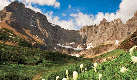
Ptarmigan Pass

Get bird’s-eye views with a twist: On this 11-mile out-and-back, you’ll go through a pass via a backcountry tunnel built in the early 1930s. Follow the Iceberg-Ptarmigan Trail 2.4 miles to overlook Ptarmigan Falls cascading into the forest. Continue 1.7 miles, past a thick patch of huckleberries (ripe in August), to tiny Ptarmigan Lake below the imposing, 7,800-foot Ptarmigan Wall. Climb to Ptarmigan Tunnel and proceed through this 250-foot-long, cool stone corridor to the arched doorway framing the soft colors of the northern Ptarmigan Wall. Option: Continue 2 miles to camp at Elizabeth Lake (permit required). Trip ID 34935
Many Glacier Loop
Get a full park immersion on this 53.4-mile loop that offers big days, big peaks, big wildlife, and big payoffs. This five-day trek will take you to four campsites (Granite Park, Fifty Mountain, Stoney Indian, and Cosley Lake) with days up to 14.5 miles. Start with 7.6 miles up and over 7,185-foot Swiftcurrent Pass, overlooking the green and pastel slopes of the Continental Divide (which you’ll traverse on day two). Cross the Stoney Indian Pass headwall, where waterfalls pour through seemingly every crevice of crinkled rock, then catch the cliffs reflected on the still surface of Cosley Lake, your fourth night’s camp. Skirt lakes in a deep valley, then pass 50-foot Dawn Mist Falls crashing over moss-covered rock before traveling through Ptarmigan Tunnel and back to Many Glacier. Trip ID2187397
Redgap Pass Trail
Sample the park’s diverse wildlife as you go from a high, talus-covered pass to gentle riverside meadows on this 24.9-mile, three-day shuttle hike. Bonus: big rewards, but relatively little effort. Start from the Ptarmigan trailhead and climb 1,223 feet in 4 miles up forested Swiftcurrent Ridge. Descend to your first night’s camp at Poia Lake (mile 6), nestled in a deep valley surrounded by cliffy peaks. Day two, climb switchbacks up rust-hued rubble to 7,527-foot Redgap Pass, a popular hangout for mountain goats (pack a long lens). Make camp at Elizabeth Lake, prime moose and loon terrain, with views of the toothy Ptarmigan Wall. Day three, hike along the Belly River Valley’s brown-trout-loaded crystal waters (ideal bear habitat) 9.4 miles to Chief Mountain Customs Station. Trip ID6929
Cracker Lake
Hike out and back to one of the park’s most eye-catching lakes on this 11.2-miler. Follow Cracker Lake Trail as it descends gradually past the marshy shore of Lake Sherburne, famous for reflecting the sprawling northern Rockies. Ascend a forested ridge to the overlook of 50-acre Cracker Lake, the aforementioned stunner, nestled between cliffs rising 3,000 feet; its turquoise color derives from light refracting off suspended glacial silt. Descend 100 feet to the shore (camping available). Option: Continue up the cirque, past the end of the trail, to the remains of the fast-melting Siyeh Glacier. Trip ID613869
Piegan Pass
Sparkling Grinnell Lake is a park must-do, but don’t stop there with the crowds; continue on this 14-mile shuttle route to cross a high pass and nab an off-trail peak. Start on the Grinnell Glacier Trail, traveling 6 miles over rocky slopes overlooking a string of glacial blue ponds. Take Piegan Pass Trail 5.7 miles, then detour off-trail for a .5-mile, class 2 scramble up the south slope of 8,180-foot Cataract Peak. Continue another 4.2 miles on the trail (look west for Piegan Glacier) and finish at Siyeh Bend. Shuttle and bus back to Many Glacier. Trip ID2182493
Shuttle Service
Connect the park’s free shuttle with the Red Bus ($10; glacierparkinc.com) to facilitate point-to-point hikes.