Updated December 4, 2024 12:11AM
Long Trail Hikes
Traverse the first long trail in Vermont.
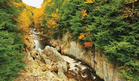
'Clarendon Gorge, along Vermont's Long Trail. (Pat & Chuck Blackley)'
| BEST HIKES EVER HOME |
Completed in 1930, the Long Trail was the country’s first long-distance path, offering a chance for thru-hikers to trace the Green Mountains’ spine from the Massachusetts border to Canada. But we declared it an “endangered trail” in 1991, when private development threatened hiker access (back then, only handshake agreements let hikers cross private tracts). Thankfully, easements were obtained and parcels protected so that today, the Long Trail remains compelling—and curse-worthy. In “America’s Worst Trail: A Love Story” (January 2010), reader David Hiscoe recounts the injury and inspiration he took away from his LT hiking experiences, and declares the trail the essence “of what the whole backpacking enterprise entails.” Many hikers hope to “walk with autumn” by starting amidst fall colors at the northern terminus and hiking south as the season progressively ignites the lower-latitude trees (writer Charlie Wood did just this for “A Creature With Many Faces,” October 2000). Views are equally thrilling when the maples part: The LT crosses many of Vermont’s bald peaks, such as 4,083-foot Camel’s Hump and the state’s highpoint, 4,393-foot Mt. Mansfield.
Do it From the Pine Cobble trailhead (which is actually in Massachusetts, near Williamstown), it’s a five-mile climb over Pine Cobble and East Mountain to the Vermont border, where the Long Trail officially begins. The remaining 272 miles yo-yo over rough terrain, turning even “short” climbs and descents into tortuous battles with mossy roots and rocks (sturdy boots are advised). Shelters allow ultralighters to dispense with a tent, but in buggy June, you’ll want protection from insects. Summits don’t provide the only photo ops: Near the border with Canada, the LT passes through the midway point between the equator and the North Pole.
Resources Driving Trailhead parking is at the end of Pine Cobble Road, 3.2 miles northeast from Main Street in Williamstown, MA.
Map/book Long Trail Map and Long Trail Guide ($19 and $10; greenmountainclub.org)
Contact (802) 244-7037; greenmountainclub.org
Beta Start planning now at backpacker.com/longtrail.