Published May 13, 2011 11:58AM
Local Hikes: Mountain West
Hike these long trails in Montana, Idaho, Arizona, and Colorado, and raft an eight-mile section of the Arkansas River.
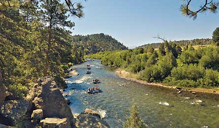
'Arkansas River in Colorado (Glenn Oakley)'
MONTANA
Continental Divide Trail (Print & Go)
Belly River
With low altitude yet big relief, this route in Glacier National Park’s little-visited northeast corner makes a great hike in late May, when much of the 3,100-mile CDT is still choked with snow. A 22.9-mile lollipop loop in the Belly River Valley cuts through beargrass-filled meadows and passes misty waterfalls to a campsite overlooking Elizabeth Lake. Trip ID 506599
IDAHO
Idaho Centennial Trail
Stanley Lake to Redfish Lake
Take this 22.5-mile scenic detour near the 900-mile ICT to access multiple scrambles up Sawtooth spires. Got spine? A scoured bedrock saddle between Williams and Thompson Peaks offers scenic but exposed camping. Trip ID 617278
WYOMING
Continental Divide Trail
Shoshone Lake to Lewis Lake
Link two expansive lakes on an 11.1-mile loop through Yellowstone’s lush meadows and lodgepole forests. At mile 4.5, descend to a narrow beach on 80,000-acre Shoshone Lake—the biggest backcountry lake in the Lower 48. A mile later, watch for bald eagles, elk, and moose along the Lewis Channel. Skirt the northern shores of Lewis Lake to close the loop.Trip ID333321
COLORADO
Colorado Trail
Stony Pass to Celebration Lake
The very best section of the 483-mile Colorado Trail lies along this 40-mile San Juans stunner. The sky-high trailhead starts at 12,500 feet and crosses crag-topped tundra before dropping past hidden waterfalls into the Animas River Valley, where the conical, 13,000-foot Grenadier peaks tower overhead. Catch the perfect postcard shot (pictured) near mile 15.4. Trip ID536991
ARIZONA
Tucson
San Pedro River
Look out, birdwatchers: The riparian zones nourished by the San Pedro River host critical habitat for more than 350 species of local and migrant fowl—including 36 raptors. After closing this 2.2-mile loop, hike three more miles to tent at Miller Backcountry Camp, says map contributor Melissa Gaskill, and wake up to a morning chorus. Trip ID680780
SEE THIS NOW
RAFT THE ARKANSAS
Arkansas Headwaters Recreation Area, CO
Payoff Call it Splash Mountain for grown-ups: In the eight-mile section through Browns Canyon, the Arkansas River’s class IV whitewater tumbles between 200-foot walls of sculpted granite topped by ponderosa and piñon pines, and visited by mountain lions and bighorns.
Time Though river flow is snowpack- and weather-dependent, runoff from the high country’s 25 feet of average annual snowfall begins fueling the Arkansas in May. The river usually peaks at 4,500 cubic feet per second in early- to mid-June, following a few consecutive nights of above-freezing temps in the higher elevations.
Place Put in at Ruby Mountain launch near Buena Vista for an 11-mile run through famed rapids like Zoom Flume and Seidel’s Suckhole (get DIY tips on page 49 or hitch a commercial ride, $50-$90). Hydrophobic? Hike 2.5 miles upstream from Hecla Junction Campground along the water’s edge to watch rafters on Raft Ripper and Widowmaker. brownscanyon.org