Published September 24, 2015 04:52PM
Hiking Wyoming’s Island in the Sky
The underappreciated Bighorn Mountains hide some of the Lower 48’s best alpine scenery.
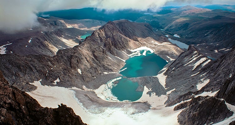
'On a clear day, you can see more than 20 alpine tarns from the Cloud Peak summit, including Glacier Lake. photo: David Muench'
From up close, Cloud Peak is one of the Cowboy State’s most impressive mountains. In the photos I’ve seen, it’s surrounded by sheer rock walls that rise more than 1,000 feet above tarns and remnant glaciers. Those huge cliffs are why a climbing friend and I came to the Bighorns during August in the first place—to scout possible first ascents.
At 13,167 feet, Cloud Peak is the tallest point in the Bighorns. But for the entire day that we approach the mountain, it hides in blowing mist, playing hard to get. It’s actually rather fitting for a mountain many hikers have never heard of, as if the clouds are literally shrouding the whole range in obscurity.
There are advantages to obscurity, of course. The Bighorns see far fewer visitors than the nearby Teton and Wind River Ranges. In Wilderness Basin, near where we are today, my friend once nearly bumped into a deer so unaccustomed to humans that he walked within spitting distance as the animal grazed.
ADVERTISEMENT
Before tackling the big cliffs, we plan to hike Cloud Peak’s single nontechnical route: the 5-mile-long southwest ridge, which we’ll approach after a night at crater-like Mistymoon Lake. Rain begins falling soon after we start up the Mistymoon Trail (#63) and enter the Cloud Peak Wilderness.
With the peaks socked in, we focus on close-at-hand vistas: the golden-brown meadows of mid-August; swaying fields of delicate harebell and royal blue larkspur; a moose splashing in a shallow pond below Lake Helen, the first in a chain of alpine lakes. The highest in the chain, Mistymoon, sits in a bowl above treeline, cliffs rising from the shore into fog. We join the Solitude Trail (#38), cross a turfy saddle, and find a campsite on a shelf lined with subalpine firs, about 6 miles from the trailhead.
Early the next morning, wet bushes soak our legs as we cross Paint Rock Creek, at around 10,125 feet, but the rising sun is already burning away the clouds and any misgivings I may have had. Hiking up steep, treeless slopes past a waterfall, we soon reach the narrowing ridge. At 12,400 feet, the hourglass ridge is less than 50 feet wide, with a 1,000-foot drop to Wilderness Basin on the left and a slightly shorter plunge on the right. In a snowfield just before the narrows, we’re amazed to see bobcat tracks marching toward the summit. Higher, I spy a young pine marten darting in and out of the talus. Cairns mark the general route up the southwest ridge, but there is no real trail. Instead, endless boulder-hopping tests my balance and the stickiness of the rubber on my boots.
ADVERTISEMENT
Given the cliffs on either side of the ridge, it’s startling to discover the summit is a broad plateau, like an island in the sky. To the north, jagged spires pop into view. Steps away from the summit cairn, completely hidden until now, the east face dives almost vertically for more than 1,000 feet to a half-moon-shaped icefield that calves bergs into Glacier Lake. Beside the lake is an imposing granite peak called the Merlon, named for the battlements of a medieval fortress. Twenty-four hours after our rain-soaked approach to the mountain, blue skies now sweep the horizon, and we’re in no hurry to leave.
Cloud Peak’s flat top offers vivid proof that you don’t hike up a mountain to see the actual summit—it’s those views you couldn’t have imagined from below that etch a mountain into memory.
Do It
Plan two or three days for the 23-mile round-trip ascent of Cloud Peak. Or, spend another night near Mistymoon and hike up 12,841-foot Bomber Mountain, just south of Cloud Peak, by its southwest ridge.
Trailhead West Tensleep (44.262402, -107.212826) Season Mid-July to early September for a mostly snow-free trail; fresh snow may fall anytime. Permits Free permit required; self-register at the trailhead. Contact fs.usda.gov/bighorn