Published July 9, 2009 04:39PM
Hike It, Save It: Upper Desolation Canyon, Utah
Oil and gas development threaten these 65,000 acres. Float the Green River to see what's at stake.
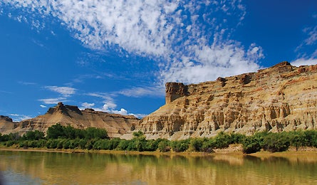
'Upper Desolation Canyon (Ray Bloxham/Suma)'
The Details With a clutch of four national parks and world-class hiking, mountain biking, rock climbing, and whitewater rafting, southern Utah is the epicenter of America’s canyon-
country treasures. But only a fraction of the region has meaningful protection, leaving millions of acres of the redrock wonderland vulnerable to development. One gem on the chopping block: Upper Desolation Canyon, a proposed wilderness where gas drillers like the Bill Barrett Corporation have already set up shop, threatening one of the largest contiguous roadless areas in the Lower 48. According to the Southern Utah Wilderness Alliance, Upper Desolation Canyon’s 65,000 acres are a top candidate for protection because the Green River along this stretch is still utterly wild. The 1999 Utah Wilderness Inventory concurred, noting that “the significant or noticeable intrusions are located outside [Upper Desolation Canyon’s] boundaries.” According to Ray Bloxham, a SUWA field inventory specialist, “The gas companies figure that if no one goes there, they can make a case that it’s not worth saving.”
The Float This tranquil portion of the Green River contrasts with the rest of Utah’s white-knuckle attractions. The lower Green, known for its whitewater, receives upwards of 500 permitted rafts annually. Upper Desolation Canyon, on the other hand, fully lives up to its name: You won’t have to share this riparian meander with anyone but your companions (and no permit needed). Put in at Pariette Draw and float south, by banks shaded by stands of sycamore trees, below broken brown cliffs and azure skies, taking three days to complete the 24-mile tour. Note the gas development in progress right on the canyon rim, at mile nine, before you enter the proposed wilderness. At mile 17, set up a basecamp for a layover day on the sandy shores of Ray’s Bottom, on river right. On day two, hike up the main drainage, heading due west. After about half a mile, turn south up the steep redrock of another drainage for about another half mile, then west where it tables off. Now atop the mesa, lope south for just under a mile to the obvious highpoint, at 5,481 feet, for a canyon panorama: red gorges rippling away in all directions and the Uinta Range piercing the sky 60 miles to the north. And complete silence–a precious commodity undoubtedly at stake. “Polluting the water and marring the landscape’s visual quality is bad enough, but people also need to know that energy development means a loss of the quiet, too. The silence is an integral part of this place’s beauty,” says Bloxham. On day three, sleep in and savor the remaining eight-mile float to the take-out at Sand Wash. You can make this trip year-round, but fall is best: Lower water means better beaches; the bugs are gone; and the temperature stays in the 60s and 70s. Design a custom trip, from car shuttles to equipment rental to menu-planning, with Desolation Outfitters in Roosevelt (desolationoutfitters.com, 800-854-4364). blm.gov/ut
The Champion The Southern Utah Wilderness Alliance (suwa.org) is pressing Congress to pass America’s Red Rock Wilderness Act, which would grant wilderness status to 9 million Utah acres, including Upper Desolation Canyon.
The Way To Pariette Draw: From Duchesne, go east on UT 40 for 13 miles to the Sand Wash Boat Launch sign. Turn right and drive south 13 miles to a dirt road on the left. Follow signs for Pariette Draw, heading east for roughly 15 miles. To Sand Wash: Same as above, but follow BLM signs for Sand Wash, 25 miles past the pavement’s end.