Updated July 2, 2025 11:56AM
Hike It, Save It: Seneca Creek, West Virginia
A two-day, 17-mile zigzag along blueberry-lined mountain ridges will give you a dose of the 24,000-acre "Crown Jewel of the Monongahela," threatened by oil and gas drilling.
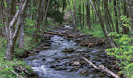
'Seneca Creek (Catherine Brooks)'
The Details Thirty years ago, this 24,000-acre “Crown Jewel of the Monongahela” scored the highest in the Mountain State’s Roadless Area Review and Evaluation. Nothing has changed since the report noted Seneca Creek’s exceptional solitude, natural integrity, and endangered species (like Cheat Mountain salamanders) as key factors that make it a prime candidate for wilderness designation. Another endorsement comes from Trout Unlimited, which ranks Seneca as one of its “top 100 trout streams” for the creek’s healthy native fish population. Seems a lock, but protection remains elusive due to political pressure from hunting groups, developers, and even a contingent of mountain bikers. The area has been part of the Spruce Knob-Seneca Rocks National Recreation Area in Monongahela National Forest since 1965, but it’s legal to drill here, and natural-gas developers are circling. In March, the Wilderness Society, together with local activist groups, successfully petitioned the BLM to deny lease auctions within the proposed wilderness area. Mary Krueger, who worked on the case for the Wilderness Society, says, “Vigilance has been our key to keeping the area pristine, but who knows when our luck will run out?”
The Hike Get a Seneca Creek highlight tour on a two-day, 17-mile zigzag along blueberry-lined mountain ridges. Descend to the eponymous creek, then climb up to 4,863-foot Spruce Knob, the state’s wind-whipped high point. From the Swallow Rock trailhead, hike southeast 2.5 miles to Allegheny Mountain, on the Eastern Continental Divide. Turn right onto the Allegheny Mountain Trail and continue 1.5 miles before taking a left onto Tom Lick Run and dropping 1.2 miles to Seneca Creek. Hike northeast three miles, along a string of inviting pools and waterfalls, until you reach stellar camping at emerald Judy Springs. As you follow the creek, notice the karst topography, a limestone formation that allows pools and underground streams to form. (The relatively porous rock would also allow groundwater contamination from gas drilling.) The next day, finish up the Seneca Creek Trail’s two remaining miles, turn briefly onto the Huckleberry Trail, then hike northwest onto the seldom-trod High Meadows Trail. From here it’s 2.1 miles of trekking through spruce and mountain laurel-lined meadows to the Lumberjack Trail. Hike 6.5 miles, linking back up with Huckleberry to reach Spruce Knob. Summer and autumn are gorgeous. fs.fed.us/r9/mnf
The Champion The West Virginia Wilderness Coalition (wvwild.org) protected 47,000 acres of Monongahela National Forest as designated wilderness via the Wild Monongahela Act.
The Way From Elkins: Go south on WV 55 for 17.7 miles; turn right onto Rich Mountain Rd. Go 8.8 miles to Swallow Rock trailhead. From Swallow Rock to Spruce Knob: Head west on Whitmer for 6.4 miles; turn left on Public Rd. 1; go three miles, turn left on Public Rd. 112 and go 5.6 miles to Public Rd. 104, which leads to parking atop the knob.