Published July 9, 2009 04:34PM
Hike It, Save It: Scotchman Peaks, Montana/Idaho
Development, bureaucracy, and apathy threaten this Glacier-like mecca, home to grizzlies, fields of beargrass, and superlative alpine hiking.
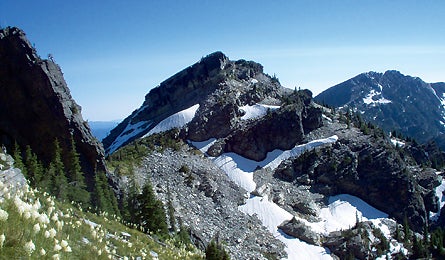
'Billiard Table Mtn (Danielle Puccinelli)'
The Details The Scotchman Peaks proposed Wilderness Area, an 88,000-acre roadless jumble of alpine peaks and grizzlies, can’t catch a break. Despite having no oil beneath it, a topography too rugged for off-highway vehicles and vacation homes, and escalating public support for wilderness designation, there’s little momentum at the legislative level to grant it full wilderness status. “We’ve beat plans for cell-phone towers, public land sales, a scenic gondola up Scotchman Peak itself, and a bureaucratic dispute between the Idaho Panhandle and Kootenai National Forests [in 2005, Kootenai NF issued a forest plan to manage the area as a ‘wildlands’ instead of a proposed wilderness],” says Phil Hough, chairman of Friends of the Scotchman Peaks Wilderness. “But without bulldozers idling at the trailhead, it’s hard to rally political support.” Ironically, the lack of an imminent destructive threat is this area’s biggest threat. Which is where the go-getters at Friends of the Scotchman Peaks come in. They issue maps to promote hiking, gather support from local hunters, fishermen, and businesses, and even lead trips into this range, which tops out at 7,000 feet and draws far less attention than the Bitterroots to the south. Hough observes, “If we generate traffic to this range–and show the four senators and two congressman how important its designation could be to the local communities–we can make this happen. All that’s missing are hikers to help us pick this low-hanging fruit.”
The Hike With grizzlies, fields of beargrass, and superlative alpine hiking, this hidden gem feels like an unexplored annex to Glacier National Park. A 17-mile loop up the west fork of Ross Creek, atop a serrated ridge, and back down another fork delivers the ideal three-day sampling of the Scotchmans’ rare beauty. Begin at the Ross Creek Cedars Scenic Area trailhead (2,800 feet), and hike west along the waterway, through old-growth cedars and hemlock trees. After four miles of steady climbing, the trail peters out, but continue due west up the drainage for another mile or so to ideal camping just below treeline, at 5,400 feet. Continue in the same direction the next day, ascending about half a mile to the ridge (just over 6,200 feet), switchbacking up a scree slope as you approach the crest. Trek six miles southbound on the ridge; expect slow going as you pick a route around blocky boulders. Sandy Compton, who pioneered this loop, says, “Think like an elk.” The ungulates regularly utilize the route. Pause at stunning views of jagged gray peaks, Blacktop Mountain immediately to the west, and the Cabinets Range 15 miles to the east. In about two miles, turn east down the obvious track on “the best-trod elk path you’ve ever seen.” It’s just below Middle Mountain, so bag 6,442-foot Middle or 6,763-foot Sawtooth if time and weather conditions permit. Drop back to the headwaters of Ross Creek’s South Fork, where you can camp in a thick bed of grass in thin spruce cover. On day three, descend six miles down the drainage into a dense forest to complete the loop (you’ll pick up the trail again after about a mile). Best season: late summer and early fall. fs.fed.us/r1/kootenai
The Champion Friends of the Scotchman Peaks Wilderness (scotchmanpeaks.org) lobbies local businesses and national politicians, and leads hikes to the area.
The Way From Coeur d’Alene, take US 95 north 43.6 miles to US 200. Go 34.2 miles to MT 56, then 16.7 miles north to NFD 398. Turn left, and go 3.8 miles to the trailhead.