Published July 9, 2009 04:54PM
Hike It, Save It: Handies Peak, Colorado
The biggest threat to his critical gap between the Weminuche and Uncompahgre Wilderness Areas? Off-highway vehicles.
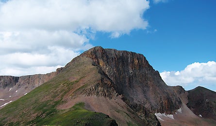
'Half Peak (John D. Kirk)'
The Details Handies is a missing link in Colorado wilderness. “This would fill a critical gap between Uncompahgre and Weminuche Wilderness Areas,” says Mark Peason, author of the Complete Guide to Colorado’s Wilderness Areas. At 71,800 acres, Handies is one of the state’s largest unprotected roadless areas, and it delivers quintessential Rockies terrain: 12 miles of the Colorado and Continental Divide Trails, the eponymous peak at 14,048 feet, a handful of Thirteeners, fields of columbine, herds of bighorn sheep, and–with a low point of 9,000 feet–plenty of alpine hiking. The northern 16,000 acres already have some safeguards as a BLM Wilderness Study Area, but OHVs threaten the remaining 55,000 acres (part of the Rio Grande National Forest). There, four-wheelers and motorcycles are permitted on trails, where they chew up the two-mile-high tundra and replace elk bugles with the roar of engines. Kurt Kunkle, of the Colorado Environmental Coalition, says keeping the machines at bay won’t be easy. “Even though this is part of a vital wildlife corridor and an obvious spot for Wilderness,” he says, “the off-highway vehicle lobby is well-entrenched, well-heeled, and doesn’t like to lose ground, despite plenty of other options in the national forest.”
The Hike Get a taste of the high country on a three-day, 21-mile loop that starts in the ghost town of Sherman. En route, you’ll tag the Continental Divide, Cataract Lake, and 13,841-foot Half Peak. The trip begins in the Wilderness Study Area (where motor vehicles are not permitted, yet still appear from time to time). Starting at 9,600 feet, hike west, gradually ascending along Cottonwood Creek for three miles, then turn south to go up the Cuba Gulch drainage. Camp near Cuba’s headwaters, four miles farther, at 11,500 feet. The next day, follow Cuba Gulch four more miles to the Continental Divide/Colorado Trail. Hike five miles, past dizzying views and through marmot and pika habitat, to 12,100-foot Cataract Lake. Set up basecamp on its north side, and climb Half Peak (the triangle on the map a mile and change northwest) early on day three. Go up a gentle ramp, then a narrow knife-edge, and finally pick your way past small, crumbling spires another half-mile to the summit. Gaze at three Fourteeners: Handies, Redcloud, and Sunshine Peaks. End the trip with a five-mile walk down the waterfall-rich Cataract Gulch to Sherman. Hike in high summer for the best wildflowers, but be aware of afternoon thunderstorms. fs.fed.us/r2/riogrande
The Champions The Colorado Environmental Coalition (ourcolorado.org) supports wilderness protection, plus water quality, energy, and global-warming issues throughout the state. The San Juan Citizens Alliance (sanjuancitizens.org) does similar work, but specifically in the San Juan Mountains of southwestern Colorado.
The Way From Lake City, head south on CO 149 for 2.6 miles to a right on CR 3. Go 12.5 miles to CR 18X; turn left and drive 2.1 miles to the trailhead.