Published October 22, 2008 06:33PM
High Point Montana
Get vertical on a tricky class 4 route to the top of Granite Peak.
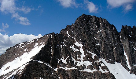
'Safe descents on weather-beaten Granite Peak take 5 hours (Vince Poore).'
The Hike
Granite Peak, at 12,799 feet, was the last of the 50 state highpoints to be
climbed (in 1923). The combination of exertion (you’ll gain 6,300 feet over
11.6 miles), unpredictable weather, and technical scrambling makes this one
of the most exciting two- to four-day backpacking trips in the Rockies. From
West Rosebud trailhead, hike to Mystic Lake’s ponderosa-lined shores. Here,
the approach vaults up 2,000 feet onto Froze-to-Death Plateau’s exposed, ankle-busting
talus and intermittent snowfields. Set up camp on the shoulder of 12,469-foot
Tempest Mountain and prepare for summit day. You’ll dip down to a saddle before
crossing The Snowbridge, a knife-edge ridge that remains covered with drifts
well into August. Then, in less than a mile, climb more than 1,000 feet of blocky
don’t-fall-here terrain to Montana’s roof. The area’s ubiquitous mountain goats
may follow you to the summit.
The Crux
Mind-spinning exposure. From The Snowbridge, you’ll navigate up class III and
IV granite. Getting down is even scarier.
The Key
Keen routefinding and proper gear. Montana’s Highest Point: A Climbing Guide
by Joe Josephson ($20, firstascentpress .com) is the definitive guide and map
for the mountain. Study up before you go, and make color copies of the guidebook’s
photo-based route descriptions to help you pick your way. Also, look for route
maps stashed in a weatherproof container just past The Snowbridge. Pack a 60-meter
rope, helmet, harness, and a belay device. Rappelling down the steepest pitch
(the last 200 feet to the summit, which some rate as class V) will ease vertigo.
Plus, if weather moves in–the mountain hides the western view of oncoming
storms–you’ll want to rap down quickly.
The Way
From Absarokee, Montana, take MT 78 2.9 miles south to a right on MT 419. Drive
7.9 miles to West Rosebud Rd. Turn right and head 6.3 miles to a left onto FR
72 and 14.2 miles of gravel to the trailhead next to the Mystic Lake Hydroelectric
Plant.
Plan It
Check weather and trail conditions at the Beartooth Ranger Station (406-446-2103;
fs.fed.us/r1/custer/recreation).