Published October 12, 2010 05:20PM
High Sierra Trail, Ca: 50-Mile Thru-Hikes
Go straight to the top in the Range of Light.
'october 2010 50 mile high sierra 200x170'
(72 miles, 5-7 days)
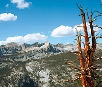
This trail has no prologue. The John Muir Trail may hold the high country in a loving embrace for weeks, but the High Sierra Trail gets right down to business. That’s because it cuts against the grain of the Sierra Nevada, from Crescent Meadow in Sequoia National Park to just shy of 14,505-foot Mt. Whitney.
Thru-hikers usually go west to east, leaving the Whitney side-trip for the final day. Most of the first two days are devoted to climbing to Kaweah Gap, a notch in the impressively vertical Great Western Divide, a range of 13,000-footers. You’ll shed that hard-won elevation in a gradual drop to Kern Canyon, a long, forested trench that looks like it was scraped out of Sierra bedrock by a giant ice cream scoop. The 49-mile HST officially ends where it intersects the JMT, but that would leave you a long way from civilization. It’s another 23 miles up the back side of Mt. Whitney and down to Whitney Portal. (559) 565-3708; nps.gov/seki
The way West trailhead: From Visalia, go 52.8 miles east on CA 198 to Moro Rock-Crescent Meadow Rd. Turn right and go 2.5 miles. East trailhead: at the end of Whitney Portal Rd., 11.4 miles west of Lone Pine.
Shuttle DIY or High Sierra Shuttle ($600/pair, highsierrashuttle.com)
Season Mid-August through September, for reliably pleasant, bug-free camping.
Guidebook and map Download the full GPS track and view geo-tagged photos in the online trip trip report at backpacker.com/hikes. Other resources in print: Sierra South, by Kathy Morey ($19, wildernesspress.com); Whitney High Country ($10, tomharrisonmaps.com).