Published June 21, 2013 12:21PM
Grand Traverses: Pfiffner Traverse
Choose your own adventure on this rocky mountain routefinding test piece.
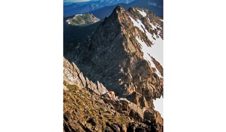
'Mark Oveson scrambles up Mt. Neva - mile 49 (Bill Wright)'
Table of Contents | Pfiffner Traverse, CO | Roan Highlands, NC/TN | Sawtooth Ridge, WA | Ruby Crest, NV | Great Northern Traverse, MT | Sierra High Route, CA | Monroe Skyline, VT | Superstition Ridge, AZ | Guadalupe Ridge, NM/TX | Teton Crest Trail, WY | Greenstone Ridge, MI | Franconia Ridge, NH | Great Range, NY
Distance 76.7 miles
Gain 21,500 feet
Difficulty 10
Why it’s grand Just west of the Front Range, the knife-edge ridges, skyscraping peaks, and icy lakes of the Indian Peaks beckon. Lucky for hikers, roads only parallel the good stuff. Pick your way (often off-trail) along the Continental Divide, and you’ll earn a full dose of off-the-grid splendor, crowds never included.
Do it Half the challenge of this adventure is figuring out where to go. The other half: a Denali’s worth of elevation change, 18 summits, volatile mountain weather, and permit red tape. The trek owes its name to Carl Pfiffner, who in the 1950s dreamed up a route connecting the Indian Peaks Wilderness and Rocky Mountain National Park (he died before attempting it). A true Divide-based traverse requires technical climbing, but fit scramblers can string together a version that skips the exposure. From Milner Pass, navigate off-trail to tag six 12,000-foot summits en route to Ptarmigan Pass. Descend on trails to Lake Nanita, then routefind cross-country to Spirit Lake. Thread your way around the cliffs on Isolation Peak’s west side, then stay high until just above Gourd Lake. Follow trails past Monarch Lake (mile 38) and up Arapaho Pass, then hug the Divide around Mt. Neva (class 4 in spots) to Devil’s Thumb. Cruise on the CDT 18.5 miles to Berthoud Pass.
In July 2011, Mark Oveson, 45, of Louisville, CO, pioneered our route in 37 hours and 44 minutes.
Contacts Rocky Mountain NP (970-586-1242; nps.gov/romo); Arapaho NF (970-295-6600; bit.ly/InPeWild)
GuidebookColorado’s Indian Peaks: Classic Hikes and Climbs by Gerry Roach (available used online)
Season July to September
Permits Required for Indian Peaks Wilderness (June 1 to September 15) and RMNP