Published August 29, 2008 05:49PM
Go Long In Pennsylvania's Laurel Highlands
On this 70-miler, see rhododendrons by day and hike light by staying in shelters at night.
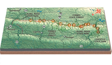
'Map by International Mapping Associates'
Shaded by a dense hardwood canopy, cut by clear, wildflower lined creeks, and pocked with postcard-worthy ridgetop views, the 70-mile Laurel Highlands Hiking Trail (LHHT) is one of the Keystone state’s marquee paths. An hour south of Pittsburgh, the Laurel Highlands hover around 2,500 feet, and stay 10 to 20 degrees cooler than the humid valley floor. Pack light: There are eight shelter sites along the five- to six-day trek. Each site is equipped with a water pump, outhouses, refuse bins, tent-camping areas, and five Adirondack-style lean-to’s, replete with stone fireplaces and built-in cooking racks.
Do it From the LHHT’s southwest terminus (1), just north of Ohiopyle, head northeast to a 2,200-foot unnamed knob (2). Stop for a jpeg of the the rushing Youghiogheny (sounds like: Yawkagainy) River below. Camp comes early at the Ohiopyle Shelters at mile 6.3 (3). Next morning, prepare for a 1.2-mile lung-buster that climbs 1,100 feet on stone staircases. Along the way, mushrooms and mosses yield to wildflowers, then towering hardwoods and fern-carpeted groves. At mile 11 (4), soak your head under a six-foot cascade streaming over 360-million-year-old rock. Watch for redback salamanders and wood ducks as you cross a small dam a mile later (5). By mile 16, large swaths mountain laurel, the state flower, line the trail (blooming through June). You’ll pass massive rock outcroppings before arriving at the Rt. 653 Shelters at mile 18 (6).
Rise early for the next day’s 14-mile trek, and you’ll have plenty of time for a mid-morning break to watch hawks at an overlook at mile 21.3 (7). Pass the Grindle Ridge Shelters in two more miles (8). Pack some cash for lunch (fresh pizza and cookies!) at the 7 Springs Mountain Resort (800-452-2223; 7springs.com) at mile 26.2 (9), the highest point on the trail. From here, hike down ski slopes, past the snowmaking ponds, and finally up switchbacks to the Rt. 31 Shelters (10).
ADVERTISEMENT
On day three, trek 12 miles through cherry, maple, beech, and hemlock, crossing a hikers’ bridge over the turnpike at mile 36. Pass the Turnpike Shelters and take a break at Beam Rock (11), an outcrop of 90-foot-high pinnacles. It’s five more wooded miles to the Rt. 30 Shelters (12) at mile 46.5.
Start day four with a quick splash in Machine Run (13), a spring 1.5 miles from camp. From here, head 9.5 miles through giant cinnamon ferns sprinkled with patches of blueberry and blackberry bushes to the Rt. 271 Shelters at mile 56.9 (14). The final day is a relatively gentle 13 miles. Be sure to stop at the lookout tower at mile 66 for a view of Conemaugh Gap and shimmering Big Spring Reservoir. From the tower, it’s four downhill miles to the trailhead.
Bring Rover In 2008, for the first time ever, dogs are allowed at overnight shelters.
Season October is prime time, with colorful foliage and great weather. It’s also when most of the 70,000 annual visitors go (less than one percent are thru-hikers). Alternatively, try spring through midsummer for roaring creeks and lighter traffic.
Look both ways Timber rattlesnakes, black bears, and poison ivy are concerns, but the biggest dangers to Zen-ed out hikers are the numerous road crossings. Be especially aware at US 30 and PA 271.
Plan It
Book
Grab the Hiker’s Guide to the Laurel Highlands Trail ($7, alleghenysc.org).
Shuttle Wilderness Voyageurs (800-272-4141, wilderness-voyageurs.com).
Permits
Required for the shelters ($4.50/night; dcnr.state.us.pa/stateparks, 724-455-3744).
The Way From Pittsburgh, drive 65 miles southeast on I-76 to PA 31/711/381. Head south 22 miles to Ohiopyle.