Full Circle: The Rocky Mountain Grand Loop

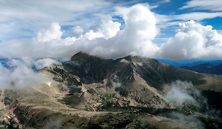
'Terrain south of Longs Peak (Airphotona - Jim Wark)'

Terrain south of Longs Peak (Airphotona – Jim Wark)

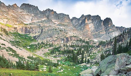
East Inlet Creek (IMAGESOFRMNP.COM

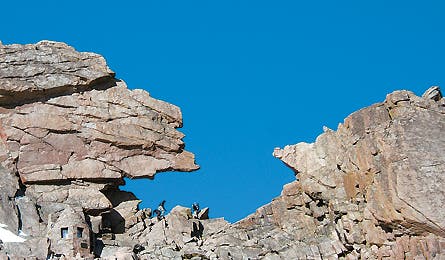
The Keyhole (Jonathan Dorn)
Avocado or peanut butter? I linger over the choice of bagel toppings, feeling no rush to smear, pack, and sprint for the summit of Longs Peak. On the opposite (northeast) side of the mountain, hundreds of storm-wary climbers undoubtedly left the standard trailhead before dawn, hoping to beat the inevitable midday lightning strikes. Not so for this lazy climber. I’m propped on a boulder by my tent, relishing the solitude. From my camp in the lonely southern side of the park, it’s just 1.5 miles to the summit, and I know I can top out by noon, even with a late start. Might as well slather another bagel with avocado and refill my French press. I’ve climbed a dozen-plus routes up Longs, but never from the south. Few people do–they’re scared off by the bushwhack approach and a 1,600-foot crawl up a scree-filled gully. But while researching a book about the 14,259-foot peak, I’d lucked into an infinitely more interesting way to reach the south face, one pioneered by two speed-hiking, Depression-era guides.
Hull Cook and Clerin Zumwalt worked at the old Boulderfield Shelter Cabin, a two-story stone hut at 12,750 feet, in the early 1930s. Every summer morning, they’d wake at 4 a.m., lead two summit climbs, and pocket $1 each. The routine was fun but grueling; it left the two little time to explore the rest of the 265,770-acre park. Until, that is, they schemed the ultimate mountain fix: a 43-mile loop across the Continental Divide and back, ending with a rare ascent of Longs from the south. The caveat? They only had one day. Like Cook and Zumwalt, I’d spent most of my 25 “Rocky” years climbing Longs and other peaks. Now ready to see the park’s remoter edges, I decided to retrace Cook and “Zumie’s” route–but not like those fast-and-lighters. Shouldering a 35-pound pack, I would savor every step of the journey, averaging a leisurely seven miles per day. The grand finale: an ascent of Longs via Keplingers Couloir.
Cook and Zumie wound down from the Boulderfield, the high camp on Longs’s mega-popular Keyhole Route. They crested 12,324-foot Flattop Mountain and the Continental Divide, and followed the 13-mile Tonahutu Creek drainage to the village of Grand Lake. After a quick lunch, they headed home along East Inlet Creek, recrossing the Divide via 12,061-foot Boulder-Grand Pass, scrambling up Longs, and descending back to the Boulderfield 24 hours after they started. I’ll take seven days to complete their loop, camping at four designated trailside sites and in one off-trail zone, resupplying in Grand Lake, and climbing Keplingers Couloir before descending Longs via the Keyhole Route. Starting at the Bear Lake trailhead last September, I grunt up 4.4 miles of switchbacks to Flattop’s summit and make my first Continental Divide crossing by noon. The Divide winds 40 miles through the heart of the park, crossing 18 named 12,000- and 13,000-foot peaks (but avoiding Longs, which lies two miles to the east). It parts watersheds–sending snowmelt to the Gulf of California via the Colorado River, and to the Gulf of Mexico via the Big Thompson. It also shapes most people’s park experience. Rocky’s 2.8 million annual visitors crowd onto trails and campgrounds in the valleys east of the Divide and north of Longs Peak, but hiker traffic drops exponentially to the west of that mountainous line.
I head northwest down the gentle tundra slopes of Bighorn Flats on the Tonahutu Creek Trail, likely following the same paths once used by the Utes and Arapahos to migrate and hunt. Two huge elk graze among wind-stunted willows. After four miles above treeline, I descend along Tonahutu Creek into the wetter, wilder west side of the park. While the landscape east of the Divide resembles the High Plains (dry, with short-grass meadows, powerful winds, and ponderosa pines), here it suggests Montana: dense spruce-fir forests, white-flowered kinnikinnick, pine marten, and moose. Only a single maintained trail–the one I’ve just followed over Flattop–crosses the Divide anywhere inside the park.
My first day is one of the hardest on this loop–I won’t reach a higher elevation until Longs Peak–and in late afternoon I’m happy to soak my feet in the icy creek at Renegade campsite. At this point, 15 miles into their hike, Cook and Zumwalt had barely gotten started, and chances are the superfit youths were still feeling peppy. Zumwalt summited Longs 53 times in 1932, still a single-year record. And Cook once draped an injured mountaineer over his back and carried him more than 500 vertical feet up Longs’s east face to the summit.
I wake up ready for a six-mile stroll along rushing Tonahutu Creek. The trail descends through spruce and fir that give way to lodgepole pines ravaged by mountain pine beetles. Pausing frequently for photos in two-mile-long Big Meadows, I set up camp just past the final meadow, where friends had told me I might spot moose feeding along the creek. At dusk, an enormous bull strides into the grass and stands almost motionless for 10 minutes. From Big Meadows, I cruise three downhill miles to the boardwalk-lined storefronts of Grand Lake. Cook and Zumie had already put in more than 25 miles by the time they arrived here. “We were getting a little bit gaunt,” Cook recalled in an interview 60 years later. The two men beelined to a café, where they made an awful discovery. “Zum thought I had money, and I thought Zum had money,” Cook said. “Between the two of us, we scraped together 37 cents–enough for one piece of pie.” They had 15 miles and 8,000 vertical feet to go.
I have a haul ahead of me, too, but carve out time for a late breakfast, plus a ceremonial slice of cherry pie at the Fat Cat Café. After stocking up on fresh spinach and tomatoes at Mountain Foods Market, I cool off in the clear water of Colorado’s largest natural lake and walk around the north shore to pick up the East Inlet Trail. This is my first time in East Inlet Valley, and it quickly joins my favorite spots in the park. The trail leads past a succession of sparkling lakes–Lone Pine, Verna, Spirit, Fourth–that pull me upward with a continuous promise of new vistas. Over seven miles, my rock climber’s eye roams the steep walls of Aiguille de Fleur and the Cleaver, tracing imaginary routes up the granite faces. Although I’ve passed other hikers today, the trails are virtually empty.
By the time I get to the Lake Verna campsite, I’m ready for my planned rest day. In the morning, I hike a couple of miles to Fifth Lake at the head of the valley, a sapphire tarn below a curving, two-mile-wide rampart of 1,000-foot cliffs and airy needles. Back at camp, I loll on the boulders by Lake Verna; at sunset, a cow elk surprises me when she splashes through the shallows.
Though no trail exists, the next day’s route over 12,061-foot Boulder-Grand Pass is the easiest way across the Divide. From Fourth Lake on, the path is only a rumor, but the pass looms directly east-northeast. I shoot a compass bearing and bushwhack uphill. Before long, the trees thin and the way becomes obvious. From the pass, I can see Longs hulking at the north side of broad Wild Basin. By the time I reach Thunder Lake, nearly 1,500 feet below the pass, a cold wind rips spray from whitecaps. I head to bed before dark.
If they were feeling gaunt in Grand Lake, Cook and Zumwalt must have been wasted by the time they traversed 11,600-foot North Ridge to reach the south face of Longs. A single slice of pie delivers 500 calories, about enough to power one hiker for an hour in this terrain. That may explain why they opted to bivouac–despite not having sleeping bags–before climbing the peak the following morning.
With a permit for Hunters Creek, I follow the same approach, albeit with a 32°F mummy and fat sleeping pad. On the Lion Lakes Trail, I spend an hour photographing columbine in the wet hollows around Lion Lakes 1 and 2, both perched on benches below 13,310-foot Mt. Alice. Following Cook and Zumie’s route over North Ridge to a campsite, I pitch my tent in a place few people camp, below a route few ever climb.
According to oral history, Arapaho tribes trapped eagles on Longs Peak’s summit. But Grand Canyon explorer John Wesley Powell led the first documented climb of the south face, in 1868. With a pack, it will be a grunt: 2,750 vertical feet from my camp, up Keplingers Couloir to the summit. With each foot placement, the views grow more spectacular–the spine of the Divide winding through the Indian Peaks Wilderness; Pikes Peak and Mt. Evans shimmering in the distance. At about 13,600 feet, I bump into the vertical Palisades cliffs and veer left over rock-strewn slabs to join the Keyhole Route just below the Homestretch–the granite ramp that leads 300 vertical feet to the summit. Already, thunderheads are building, so I snapshot the view and join the first people I’ve seen in more than 24 hours for the descent. After popping through the Keyhole to Longs’s north side, I wind down to the Boulderfield. It’s eight miles of downhill hiking to my car, and I pause to refill bottles and fuel up on gorp. Three generations before me, Hull Cook and Clerin Zumwalt ended their loop here in time for breakfast. After a week on the same route, I’m amazed at their feat, but can’t help indulging in a little one-upsmanship: Yes, the whippets made history, but they didn’t savor the best-kept secrets on the most-secret side of the Rockies’ iconic park.
Colorado-based outdoor writer Dougald MacDonald has summited Longs Peak a dozen times since 1982. The Rocky Mountain Grand Loop
Explore the quieter side of “Colorado’s park” on the author’s historically inspired route.
Hike It
This trip starts with a bang: a 4.4-mile, 2,874-foot climb from Bear Lake trailhead (1) to 12,324-foot Flattop Mountain (2). Head northwest on Tonahutu Creek Trail 3.5 miles across Bighorn Flats; end just below treeline at Renegade campsite (3). The next day, stroll downhill 4.5 miles to Big Meadows and camp in .75 to 1.5 miles at South Meadows or Paintbrush campsites. From here, it’s less than two hours to the village of Grand Lake. Follow Summerland Park and West Portal Roads for 1.5 miles to East Inlet trailhead (4).
Walk up the East Inlet drainage 6.6 miles to Lake Verna (5) for the best campsite in the valley. Take a rest day and explore the emerald-grass shores of Fifth Lake, below aptly named Isolation Peak (13,118 feet). To reach Boulder-Grand Pass (6), follow an unmaintained trail east, past Spirit Lake, to the north side of Fourth Lake. Bushwhack steeply to the east-northeast to the 12,061-foot pass. Descend the east side, skirting a permanent snowfield alongside a steep gully on the left (north). Continue to the designated campsite just east of the patrol cabin (7) beside Thunder Lake. On day six, climb northeast through open forest to the Lion Lake Trail. After a .5-mile side trip to explore the wildflowers around the Lion Lakes and Trio Falls, follow game trails east from Lion Lake No. 1 (8), climbing about 500 vertical feet to North Ridge, just west of Mt. Orton. Contour down the far side to the north and camp at the upper end of the Hunters Creek (9) cross-country zone.
Next morning, climb to the cirque below Longs Peak’s south face. Keplingers Couloir (10) rises steeply for 1,600 feet to the Notch, between Longs and Mt. Meeker. A few simple hand-and-foot moves are required to pass obstacles; keep right when in doubt until you reach the base of the Palisades cliffs (11). Expect snow in this chute until late June.
Traverse left across exposed slabs to the Keyhole Route; follow red-and-yellow blazes to the cleaved summit of Longs Peak (14,259 ft.) (12). Finish an exhausting day with a 10-mile, 4,800-foot descent of the Keyhole Route, North Longs Peak Trail, and Glacier Gorge Trail (13) to close this 43-mile loop.
The Way
Go 9 miles on Bear Lake Road from the Beaver Meadows entrance to a large lot.
When to go Wildflowers explode in mid-July; elk bugle in September. Check conditions on Longs’s upper faces before starting–snow and ice may require technical skills (plus an ice axe and crampons) in shoulder seasons.
Map and GuidebookTrails Illustrated #200 ($12; trailsillustrated.com); Rocky Mountain National Park: The Complete Hiking Guide, by Lisa Foster ($28, westcliffepublishers.com)
Go Guided Kaiyote Tours leads multiday backpacking and wildlife trips ($270 per day for two people; kaiyotetours.com).
Permits Reserve permits ($20 per trip) by phone starting March 1; after May 15, mail in requests or apply in person at the backcountry office beside the Beaver Meadows visitor center: nps.gov/romo, (970) 586-1242; Backcountry Office, Estes Park, CO 80517. Permitted backcountry camping is limited to seven consecutive nights per party.
Vacation Planner Get hotel, restaurant, and great travel beta at nationalparktrips.com/rockymountainpark.aspx.
